TopoQuest Logo
Do you find TopoQuest useful?
Help keep TopoQuest running and adding new maps/features by donating!
Bitcoin:  19c7KJd3qBynnjoSw5npx9KScwjBe4ifkT
Litecoin:  LXs6TkuXGGXo1vDsWCkWVdjQX94eUKd6ui
Home View Maps Find Maps Find Places Resources & Links


C Bar Ranch, New Mexico Topographic Map

USGS Map Title: C Bar Ranch, NM
USGS Map MRC: 32108D4
DRG (GeoTIFF) Download: o32108d4.tif


Neighboring USGS Topographic Map Quads:


  Eagle Eye Peak, NM  
32108E5
 

  Burro Peak, NM  
32108E4
 

  White Signal, NM  
32108E3
 

  Gold Hill, NM  
32108D5
 

  C Bar Ranch, NM  
32108D4
 

  Werney Hill, NM  
32108D3
 

  Lisbon, NM  
32108C5
 

  Ninetysix Ranch, NM  
32108C4
 

  Soldiers Farewell Hill, NM  
32108C3


Map MRC Location:

N33°
W109°
N33°
W108°
H8 H7 H6 H5 H4 H3 H2 H1
G8 G7 G6 G5 G4 G3 G2 G1
F8 F7 F6 F5 F4 F3 F2 F1
E8 E7 E6 E5 E4 E3 E2 E1
D8 D7 D6 D5 D4 D3 D2 D1
C8 C7 C6 C5 C4 C3 C2 C1
B8 B7 B6 B5 B4 B3 B2 B1
A8 A7 A6 A5 A4 A3 A2 A1
N32°
W109°
N32°
W108°

C Bar Ranch, NM USGS 1:24K Topographic Map Preview:
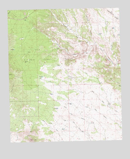
C Bar Ranch, NM USGS Topographic Map
Click on map above to begin viewing in our Map Viewer.

This topographic map contains these locations and features:
Feature Name Type Latitude Longitude GNIS ID View Map
American DepositMineN32.3895°W108.3798°914862View Map
Barrow WindmillLocaleN32.4887°W108.4109°903590View Map
Big Laddie TankReservoirN32.4064°W108.4470°903795View Map
Big TankReservoirN32.4809°W108.3822°903814View Map
Blacktail TankReservoirN32.4365°W108.4631°2038373View Map
Bounds RanchLocaleN32.3840°W108.4187°904030View Map
Burro Cienga TankReservoirN32.4566°W108.3917°936632View Map
C Bar CanyonValleyN32.4654°W108.4056°904262View Map
C Bar RanchLocaleN32.4631°W108.4428°904263View Map
C Bar Water WellWellN32.4609°W108.4431°919502View Map
Double Strike DepositMineN32.4251°W108.3895°914874View Map
Glaze RanchLocaleN32.4681°W108.4112°906561View Map
Glaze ReservoirReservoirN32.4691°W108.4192°906562View Map
Glaze WellWellN32.3923°W108.4556°906563View Map
Gold Hill TankReservoirN32.4629°W108.4943°906616View Map
Gunn TankReservoirN32.4263°W108.3760°906779View Map
Hall DrawValleyN32.4662°W108.3848°906813View Map
Hookedy TankReservoirN32.4756°W108.3988°907071View Map
Jones RanchLocaleN32.3920°W108.4089°907432View Map
Jones WindmillLocaleN32.3854°W108.4784°907436View Map
Juniper Spring TankReservoirN32.4904°W108.4806°2038525View Map
Kramer WindmillLocaleN32.4806°W108.4309°907589View Map
Little Laddie TankReservoirN32.4103°W108.4314°908031View Map
Little TankReservoirN32.4748°W108.3764°2038541View Map
Little WindmillLocaleN32.4092°W108.3889°908072View Map
Lonesome TankReservoirN32.4217°W108.4726°936631View Map
Mine TankReservoirN32.3868°W108.4407°908780View Map
Myers CanyonValleyN32.4070°W108.3898°908996View Map
Picnic CanyonValleyN32.4559°W108.4256°909613View Map
Prevost WindmillLocaleN32.4515°W108.3884°909849View Map
Seep TankReservoirN32.4905°W108.4799°910929View Map
Silver City DrawValleyN32.4462°W108.3781°911062View Map
Smith WindmillLocaleN32.4295°W108.3987°911159View Map
Taylor CanyonValleyN32.4295°W108.4006°911556View Map
Taylor WindmillsLocaleN32.4348°W108.4298°911566View Map
Walker TankReservoirN32.4201°W108.4524°912141View Map
Walking X CanyonValleyN32.4654°W108.4056°912144View Map
Werney FlatFlatN32.4729°W108.4853°912216View Map
Whitetail CanyonValleyN32.4659°W108.4039°912335View Map
Whitetop HillSummitN32.4512°W108.4825°912342View Map
Whitetop WellWellN32.4604°W108.4789°2038757View Map
Whitetop WindmillLocaleN32.4601°W108.4787°912343View Map
Willis WindmillLocaleN32.4579°W108.4120°912397View Map

Note: Coordinates in the location and feature list above are referenced to NAD83 datum.


Copyright (C) 2008-2025 Ryan Niemi / Sunset Dynamics ... All Rights Reserved