TopoQuest Logo
Do you find TopoQuest useful?
Help keep TopoQuest running and adding new maps/features by donating!
Bitcoin:  19c7KJd3qBynnjoSw5npx9KScwjBe4ifkT
Litecoin:  LXs6TkuXGGXo1vDsWCkWVdjQX94eUKd6ui
Home View Maps Find Maps Find Places Resources & Links


California North, Missouri Topographic Map

USGS Map Title: California North, MO
USGS Map MRC: 38092F5
DRG (GeoTIFF) Download: o38092f5.tif


Neighboring USGS Topographic Map Quads:


  Lone Elm, MO  
38092G6
 

  Prairie Home, MO  
38092G5
 

  Jamestown, MO  
38092G4
 

  Clarksburg, MO  
38092F6
 

  California North, MO  
38092F5
 

  Centertown NW, MO  
38092F4
 

  Latham, MO  
38092E6
 

  California South, MO  
38092E5
 

  Russellville, MO  
38092E4


Map MRC Location:

N39°
W93°
N39°
W92°
H8 H7 H6 H5 H4 H3 H2 H1
G8 G7 G6 G5 G4 G3 G2 G1
F8 F7 F6 F5 F4 F3 F2 F1
E8 E7 E6 E5 E4 E3 E2 E1
D8 D7 D6 D5 D4 D3 D2 D1
C8 C7 C6 C5 C4 C3 C2 C1
B8 B7 B6 B5 B4 B3 B2 B1
A8 A7 A6 A5 A4 A3 A2 A1
N38°
W93°
N38°
W92°

California North, MO USGS 1:24K Topographic Map Preview:
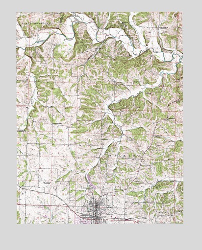
California North, MO USGS Topographic Map
Click on map above to begin viewing in our Map Viewer.

This topographic map contains these locations and features:
Feature Name Type Latitude Longitude GNIS ID View Map
Aurora High School (historical)SchoolN38.6317°W92.5680°713487View Map
Block CemeteryCemeteryN38.6822°W92.5855°735520View Map
Bowlin CemeteryCemeteryN38.6500°W92.5369°714582View Map
CaliforniaPopulated PlaceN38.6275°W92.5666°766152View Map
California City CemeteryCemeteryN38.6275°W92.5519°2702474View Map
California City Fire DepartmentBuildingN38.6278°W92.5577°2621656View Map
California Elementary SchoolSchoolN38.6325°W92.5681°2571118View Map
California High SchoolSchoolN38.6347°W92.5932°2571121View Map
California Middle SchoolSchoolN38.6313°W92.5681°2571120View Map
California Police DepartmentBuildingN38.6286°W92.5659°2752531View Map
California Post OfficePost OfficeN38.6342°W92.5651°2779499View Map
California Rural Fire Protection District Kliever Fire StationBuildingN38.6994°W92.5022°2620806View Map
California Rural Fire Protection District Main StationBuildingN38.6287°W92.5661°2621655View Map
City of CaliforniaCivilN38.6304°W92.5667°2393495View Map
Department of Conservation California Central Field Fire OfficeBuildingN38.6279°W92.5713°2620705View Map
East Brush CreekStreamN38.7239°W92.5005°717261View Map
Gooseberry HollowValleyN38.7325°W92.5599°718606View Map
High Prairie School (historical)SchoolN38.6503°W92.6038°719558View Map
Highland School (historical)SchoolN38.6745°W92.5613°719578View Map
Howard CemeteryCemeteryN38.6864°W92.6013°719911View Map
Howard CreekStreamN38.7278°W92.5263°719917View Map
KlieverPopulated PlaceN38.6973°W92.5035°729328View Map
Kraemer School (historical)SchoolN38.6486°W92.5310°720692View Map
KZMO-AM (California)TowerN38.6367°W92.5835°754297View Map
KZMO-FM (California)TowerN38.6367°W92.5849°759062View Map
Martin School (historical)SchoolN38.7189°W92.5885°721936View Map
Moniteau ChurchChurchN38.7434°W92.5449°722526View Map
Moniteau CountyCivilN38.6328°W92.5831°758522View Map
Moniteau County Sheriff's OfficeBuildingN38.6371°W92.5660°2752315View Map
New Salem ChurchChurchN38.6864°W92.5119°723309View Map
North Carolina SchoolLocaleN38.7409°W92.5185°723437View Map
Number 576 DamDamN38.6417°W92.5769°762972View Map
Oak Grove School (historical)SchoolN38.7089°W92.5374°723602View Map
Old Salem CemeteryCemeteryN38.6748°W92.5424°2702476View Map
Old Salem ChurchChurchN38.6748°W92.5413°723785View Map
Phillips FieldAirportN38.6395°W92.5285°758615View Map
Pisgah CreekStreamN38.7314°W92.6121°724440View Map
Pleasant Ridge School (historical)SchoolN38.6773°W92.5232°724605View Map
Rohrback CemeteryCemeteryN38.6750°W92.5621°725539View Map
Schaaf CreekStreamN38.7442°W92.5774°726090View Map
Schmutz CemeteryCemeteryN38.6322°W92.5021°726108View Map
South Carolina School (historical)SchoolN38.7353°W92.5182°743642View Map
Steelhouse BridgeBridgeN38.7322°W92.6094°755415View Map
Strickfaden CemeteryCemeteryN38.7425°W92.6032°727179View Map
Township of WalkerCivilN38.6506°W92.5188°767035View Map
Walnut Grove School (historical)SchoolN38.6845°W92.5982°728313View Map
West Brush CreekStreamN38.7275°W92.6185°728538View Map

Note: Coordinates in the location and feature list above are referenced to NAD83 datum.


Copyright (C) 2008-2025 Ryan Niemi / Sunset Dynamics ... All Rights Reserved