TopoQuest Logo
Do you find TopoQuest useful?
Help keep TopoQuest running and adding new maps/features by donating!
Bitcoin:  19c7KJd3qBynnjoSw5npx9KScwjBe4ifkT
Litecoin:  LXs6TkuXGGXo1vDsWCkWVdjQX94eUKd6ui
Home View Maps Find Maps Find Places Resources & Links


Curwensville, Pennsylvania Topographic Map

USGS Map Title: Curwensville, PA
USGS Map MRC: 40078H5
DRG (GeoTIFF) Download: o40078h5.tif


Neighboring USGS Topographic Map Quads:


  Luthersburg, PA  
41078A6
 

  Elliott Park, PA  
41078A5
 

  Clearfield, PA  
41078A4
 

  Mahaffey, PA  
40078H6
 

  Curwensville, PA  
40078H5
 

  Glen Richey, PA  
40078H4
 

  Westover, PA  
40078G6
 

  Irvona, PA  
40078G5
 

  Ramey, PA  
40078G4


Map MRC Location:

N41°
W79°
N41°
W78°
H8 H7 H6 H5 H4 H3 H2 H1
G8 G7 G6 G5 G4 G3 G2 G1
F8 F7 F6 F5 F4 F3 F2 F1
E8 E7 E6 E5 E4 E3 E2 E1
D8 D7 D6 D5 D4 D3 D2 D1
C8 C7 C6 C5 C4 C3 C2 C1
B8 B7 B6 B5 B4 B3 B2 B1
A8 A7 A6 A5 A4 A3 A2 A1
N40°
W79°
N40°
W78°

Curwensville, PA USGS 1:24K Topographic Map Preview:
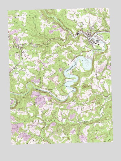
Curwensville, PA USGS Topographic Map
Click on map above to begin viewing in our Map Viewer.

This topographic map contains these locations and features:
Feature Name Type Latitude Longitude GNIS ID View Map
Anderson CreekStreamN40.9720°W78.5203°1168285View Map
B and W Junction StationLocaleN40.9776°W78.5492°1213010View Map
Belfast Number 2 Mine StationLocaleN40.9667°W78.6047°1213013View Map
Benjamin Number 7 Mine StationLocaleN40.9673°W78.5797°1213014View Map
Big RunLocaleN40.9181°W78.5156°1201275View Map
Bilger RocksPillarN40.9937°W78.5931°1209246View Map
Bilger RocksPopulated PlaceN40.9939°W78.5922°1203093View Map
Bilger RunStreamN40.9723°W78.5697°1169617View Map
BloomingtonPopulated PlaceN40.9389°W78.5172°1169855View Map
Borough of CurwensvilleCivilN40.9735°W78.5189°1215098View Map
Borough of GrampianCivilN40.9647°W78.6114°1215101View Map
Borough of Lumber City (historical)CivilN40.9289°W78.5724°1215104View Map
BridgeportPopulated PlaceN40.9753°W78.5511°1203150View Map
Caldwell School (historical)SchoolN40.8876°W78.5059°1201276View Map
Campbell RunStreamN40.8823°W78.5867°1171132View Map
Carson RunStreamN40.8939°W78.5395°1171274View Map
CB Junction StationLocaleN40.9784°W78.5114°1213011View Map
Curry School (historical)SchoolN40.9126°W78.5356°1201273View Map
CurwensvillePopulated PlaceN40.9756°W78.5250°1172861View Map
Curwensville DamDamN40.9540°W78.5263°1213616View Map
Curwensville LakeReservoirN40.9145°W78.5603°1172862View Map
Curwensville Post OfficePost OfficeN40.9763°W78.5273°2773109View Map
Curwensville Rescue Hose and Ladder Ambulance ServiceBuildingN40.9751°W78.5268°2719584View Map
Curwensville Rescue Hose and Ladder Fire CompanyBuildingN40.9751°W78.5258°2645062View Map
Curwensville State ParkParkN40.9409°W78.5450°1209244View Map
Fenton RunStreamN40.9773°W78.5867°1174685View Map
Ferguson CemeteryCemeteryN40.9233°W78.5492°1174687View Map
Friends CemeteryCemeteryN40.9569°W78.6046°1175253View Map
Friendship TunnelTunnelN40.9131°W78.5950°1175270View Map
Gazzam RunStreamN40.8945°W78.5770°1175494View Map
GoodLocaleN40.9195°W78.5592°1175791View Map
GrampianPopulated PlaceN40.9659°W78.6131°1175928View Map
Grampian - Penn - Bloom Volunteer Fire Company Station 9BuildingN40.9652°W78.6127°2645360View Map
Grampian Post OfficePost OfficeN40.9654°W78.6130°2772724View Map
Grandview Golf CourseLocaleN40.9098°W78.5714°1205599View Map
HepburniaPopulated PlaceN40.9464°W78.6153°1176860View Map
Hiles RunStreamN40.9262°W78.5872°1177066View Map
Hoyt TunnelTunnelN40.9148°W78.6139°1177528View Map
Hughey RunStreamN40.9998°W78.6025°1177570View Map
Irvin ParkParkN40.9637°W78.5142°1177864View Map
KerrmoorPopulated PlaceN40.8926°W78.5820°1178408View Map
Kratzer RunStreamN40.9764°W78.5467°1178666View Map
Locust Ridge School (historical)SchoolN40.9876°W78.5742°1201278View Map
Lumber CityPopulated PlaceN40.9242°W78.5750°1180076View Map
McClure CemeteryCemeteryN40.9558°W78.5434°1180638View Map
Millikens StationLocaleN40.9953°W78.5778°1213015View Map
New MillportPopulated PlaceN40.8937°W78.5386°1182351View Map
New Millport Post OfficePost OfficeN40.8935°W78.5390°2772873View Map
Oak Hill CemeteryCemeteryN40.9796°W78.5266°1182772View Map
Oakland School (historical)SchoolN40.9478°W78.5411°1201274View Map
OlantaPopulated PlaceN40.9167°W78.5064°1182894View Map
Olanta Post OfficePost OfficeN40.9174°W78.5046°2772890View Map
Passmore RunStreamN40.9439°W78.5561°1183354View Map
Porter RunStreamN40.9470°W78.5506°1184297View Map
RowlesLocaleN40.9581°W78.5159°1201277View Map
Rowles StationLocaleN40.9276°W78.6047°1213012View Map
Salem ChurchChurchN40.8964°W78.5428°1186849View Map
Shannon Smokeless Mine StationLocaleN40.9595°W78.5322°1213009View Map
Snyder CemeteryCemeteryN40.9061°W78.5248°1187951View Map
StronachPopulated PlaceN40.9656°W78.5889°1188885View Map
Summit Ridge School (historical)SchoolN40.9653°W78.5564°1201279View Map
Township of FergusonCivilN40.8817°W78.6068°1216233View Map
Township of PikeCivilN40.9869°W78.5379°1216245View Map
Watts CemeteryCemeteryN40.9084°W78.6140°1190700View Map
Watts CreekStreamN40.8945°W78.5770°1190701View Map
Williams CemeteryCemeteryN40.9063°W78.5470°1191458View Map
Zion ChurchChurchN40.8956°W78.5828°1192006View Map

Note: Coordinates in the location and feature list above are referenced to NAD83 datum.


Copyright (C) 2008-2024 Ryan Niemi / Sunset Dynamics ... All Rights Reserved