TopoQuest Logo
Do you find TopoQuest useful?
Help keep TopoQuest running and adding new maps/features by donating!
Bitcoin:  19c7KJd3qBynnjoSw5npx9KScwjBe4ifkT
Litecoin:  LXs6TkuXGGXo1vDsWCkWVdjQX94eUKd6ui
Home View Maps Find Maps Find Places Resources & Links


Collins, Mississippi Topographic Map

USGS Map Title: Collins, MS
USGS Map MRC: 31089F5
DRG (GeoTIFF) Download: o31089f5.tif


Neighboring USGS Topographic Map Quads:


  Magee South, MS  
31089G6
 

  Mize, MS  
31089G5
 

  Taylorsville, MS  
31089G4
 

  Lone Star, MS  
31089F6
 

  Collins, MS  
31089F5
 

  Hot Coffee, MS  
31089F4
 

  Lake Mike Connor, MS  
31089E6
 

  Williamsburg, MS  
31089E5
 

  Seminary, MS  
31089E4


Map MRC Location:

N32°
W90°
N32°
W89°
H8 H7 H6 H5 H4 H3 H2 H1
G8 G7 G6 G5 G4 G3 G2 G1
F8 F7 F6 F5 F4 F3 F2 F1
E8 E7 E6 E5 E4 E3 E2 E1
D8 D7 D6 D5 D4 D3 D2 D1
C8 C7 C6 C5 C4 C3 C2 C1
B8 B7 B6 B5 B4 B3 B2 B1
A8 A7 A6 A5 A4 A3 A2 A1
N31°
W90°
N31°
W89°

Collins, MS USGS 1:24K Topographic Map Preview:
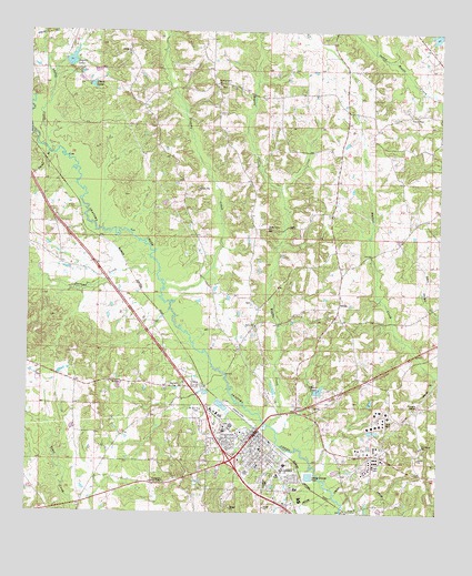
Collins, MS USGS Topographic Map
Click on map above to begin viewing in our Map Viewer.

This topographic map contains these locations and features:
Feature Name Type Latitude Longitude GNIS ID View Map
Blakely CreekStreamN31.6829°W89.5837°690906View Map
Blakely Creek Baptist ChurchChurchN31.7363°W89.5673°667263View Map
Blakley CemeteryCemeteryN31.7357°W89.5673°710617View Map
Blakley CreekPopulated PlaceN31.7363°W89.5695°710618View Map
Blakley Creek School (historical)SchoolN31.7363°W89.5670°710619View Map
Burtons CreekStreamN31.6877°W89.5851°667847View Map
Carver High School (historical)SchoolN31.6466°W89.5651°710622View Map
Chain LakeReservoirN31.7360°W89.6060°668294View Map
City of CollinsCivilN31.6470°W89.5669°2404101View Map
City of Collins Fire DepartmentBuildingN31.6447°W89.5546°2667684View Map
CollinsPopulated PlaceN31.6454°W89.5553°668700View Map
Collins CemeteryCemeteryN31.6360°W89.5576°710627View Map
Collins City HallBuildingN31.6446°W89.5565°710626View Map
Collins City Police DepartmentBuildingN31.6451°W89.5541°2754177View Map
Collins Elementary SchoolSchoolN31.6418°W89.5540°710628View Map
Collins High SchoolSchoolN31.6363°W89.5470°710629View Map
Collins Jaycee Airport (historical)AirportN31.6513°W89.5601°680323View Map
Collins Junior High SchoolSchoolN31.6466°W89.5651°710630View Map
Collins Post OfficePost OfficeN31.6439°W89.5554°2768714View Map
Collins Sewage Lagoon DamDamN31.6352°W89.5401°680796View Map
Coulters Pond DamDamN31.6585°W89.5734°680810View Map
Covington CountyCivilN31.6332°W89.5526°695740View Map
Covington County CourthouseBuildingN31.6441°W89.5567°710633View Map
Covington County HospitalHospitalN31.6373°W89.5546°710634View Map
Covington County Sheriff's OfficeBuildingN31.6448°W89.5553°2754209View Map
Covington County Vocational Technical CenterSchoolN31.6377°W89.5465°710635View Map
Covington Lookout TowerTowerN31.6332°W89.5826°711221View Map
Gibson LakeReservoirN31.6569°W89.5363°670382View Map
Gibson Lake DamDamN31.6568°W89.5367°680809View Map
Jones ChapelChurchN31.7279°W89.5092°671976View Map
Jones Chapel School (historical)SchoolN31.7279°W89.5092°710650View Map
KolaPopulated PlaceN31.6252°W89.5273°691991View Map
Kola CemeteryCemeteryN31.6324°W89.5240°710652View Map
Kola Church (historical)ChurchN31.6324°W89.5237°710653View Map
Kola School (historical)SchoolN31.6324°W89.5237°710654View Map
Legion LakeReservoirN31.7425°W89.6126°672396View Map
Legion Lake DamDamN31.7435°W89.6151°680874View Map
MishPopulated PlaceN31.6841°W89.5973°710674View Map
Mount Sinai ChurchChurchN31.6588°W89.5992°674269View Map
Mount Zion ChurchChurchN31.6518°W89.5720°674339View Map
OraPopulated PlaceN31.6577°W89.5745°675300View Map
Ora Baptist ChurchChurchN31.6588°W89.5776°710703View Map
Ora CemeteryCemeteryN31.6582°W89.5817°675301View Map
Ora School (historical)SchoolN31.6585°W89.5745°711721View Map
Ora SwampSwampN31.6627°W89.5626°710704View Map
ProvidencePopulated PlaceN31.6404°W89.5056°710706View Map
Providence Baptist ChurchChurchN31.6424°W89.5053°710707View Map
Providence SchoolSchoolN31.6424°W89.5048°676400View Map
Robertson ParkParkN31.6327°W89.5509°676715View Map
Rocky Valley ChurchChurchN31.6991°W89.5523°676808View Map
Rocky Valley School (historical)SchoolN31.6838°W89.5520°710711View Map
Rogers CemeteryCemeteryN31.6799°W89.5576°710712View Map
Rogers CreekStreamN31.6477°W89.5509°694600View Map
Rogers School (historical)SchoolN31.6810°W89.5298°710713View Map
SalemPopulated PlaceN31.6804°W89.5303°692202View Map
Salem Baptist ChurchChurchN31.6738°W89.5556°677272View Map
Salem CemeteryCemeteryN31.6738°W89.5548°710715View Map
Shelby CreekStreamN31.7193°W89.6165°677636View Map
Spring Hill ChurchChurchN31.7441°W89.5951°678112View Map
Supervisor District 3CivilN31.6642°W89.5711°711835View Map
Tanner BranchStreamN31.7182°W89.6195°678559View Map
Vennie ParkPopulated PlaceN31.6321°W89.5459°710740View Map
WKNZ-FM (Collins)TowerN31.6571°W89.5209°680198View Map

Note: Coordinates in the location and feature list above are referenced to NAD83 datum.


Copyright (C) 2008-2025 Ryan Niemi / Sunset Dynamics ... All Rights Reserved