TopoQuest Logo
Do you find TopoQuest useful?
Help keep TopoQuest running and adding new maps/features by donating!
Bitcoin:  19c7KJd3qBynnjoSw5npx9KScwjBe4ifkT
Litecoin:  LXs6TkuXGGXo1vDsWCkWVdjQX94eUKd6ui
Home View Maps Find Maps Find Places Resources & Links


Ethelsville, Alabama Topographic Map

USGS Map Title: Ethelsville, AL
USGS Map MRC: 33088D2
DRG (GeoTIFF) Download: o33088d2.tif


Neighboring USGS Topographic Map Quads:


  Steens, MS  
33088E3
 

  Fernbank, AL  
33088E2
 

  Millport, AL  
33088E1
 

  New Hope, MS  
33088D3
 

  Ethelsville, AL  
33088D2
 

  Reform, AL  
33088D1
 

  Forreston, MS  
33088C3
 

  Reform SW, AL  
33088C2
 

  Carrollton, AL  
33088C1


Map MRC Location:

N34°
W89°
N34°
W88°
H8 H7 H6 H5 H4 H3 H2 H1
G8 G7 G6 G5 G4 G3 G2 G1
F8 F7 F6 F5 F4 F3 F2 F1
E8 E7 E6 E5 E4 E3 E2 E1
D8 D7 D6 D5 D4 D3 D2 D1
C8 C7 C6 C5 C4 C3 C2 C1
B8 B7 B6 B5 B4 B3 B2 B1
A8 A7 A6 A5 A4 A3 A2 A1
N33°
W89°
N33°
W88°

Ethelsville, AL USGS 1:24K Topographic Map Preview:
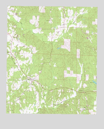
Ethelsville, AL USGS Topographic Map
Click on map above to begin viewing in our Map Viewer.

This topographic map contains these locations and features:
Feature Name Type Latitude Longitude GNIS ID View Map
Brown Hill CemeteryCemeteryN33.4393°W88.1884°158797View Map
Brown Hill Church (historical)ChurchN33.4423°W88.1892°158982View Map
Burdine CreekStreamN33.3879°W88.1978°115218View Map
Church of GodChurchN33.4279°W88.2025°135490View Map
DelmaPopulated PlaceN33.3862°W88.1845°156263View Map
Elbethel ChurchChurchN33.3937°W88.2317°158822View Map
EthelsvillePopulated PlaceN33.4157°W88.2167°118045View Map
Ethelsville Baptist ChurchChurchN33.4121°W88.2148°138738View Map
Ethelsville CemeteryCemeteryN33.4126°W88.2147°138739View Map
Ethelsville DivisionCivilN33.4393°W88.1947°165924View Map
Ethelsville Post OfficePost OfficeN33.4160°W88.2178°167750View Map
Ethelsville United Methodist ChurchChurchN33.4148°W88.2150°143018View Map
First Free Will Baptist ChurchChurchN33.4168°W88.2178°138740View Map
Forest Church CemeteryCemeteryN33.4629°W88.2403°135521View Map
Forest Methodist ChurchChurchN33.4637°W88.2417°118488View Map
Gore CemeteryCemeteryN33.3865°W88.1639°119176View Map
Hickory Grove ChurchChurchN33.4762°W88.1714°120032View Map
John McShan Number 3 DamDamN33.4085°W88.1250°131521View Map
LibertyPopulated PlaceN33.4760°W88.1700°135559View Map
Liberty High SchoolSchoolN33.4787°W88.1717°121566View Map
Liberty SchoolSchoolN33.4798°W88.1709°121577View Map
Liberty Volunteer Fire DepartmentBuildingN33.4798°W88.1708°2683128View Map
MacedoniaPopulated PlaceN33.3915°W88.2334°1669448View Map
Macedonia - Ethelsville Volunteer Fire DepartmentBuildingN33.3913°W88.2324°2683129View Map
Macedonia Census Designated PlaceCensusN33.4031°W88.2392°2633142View Map
Macedonia ChurchChurchN33.3918°W88.2325°122162View Map
Martin CemeteryCemeteryN33.3790°W88.2403°122322View Map
McShanPopulated PlaceN33.3810°W88.1417°122601View Map
McShan Lake Number ThreeReservoirN33.4085°W88.1250°131520View Map
McShan Post OfficePost OfficeN33.3812°W88.1417°167749View Map
McShan Volunteer Fire DepartmentBuildingN33.3813°W88.1420°2683183View Map
Mineral Springs CemeteryCemeteryN33.4012°W88.1434°158608View Map
Mineral Springs ChurchChurchN33.4023°W88.1436°122866View Map
Mount Moriah CemeteryCemeteryN33.3834°W88.1697°138751View Map
Mount Moriah Freewill Baptist ChurchChurchN33.3835°W88.1700°152447View Map
Old El Bethel CemeteryCemeteryN33.3943°W88.2317°158614View Map
Old Mount Moriah CemeteryCemeteryN33.4209°W88.1300°135594View Map
Phoenix CemeteryCemeteryN33.3843°W88.1384°158615View Map
Phoenix ChurchChurchN33.3846°W88.1384°135599View Map
Providence CemeteryCemeteryN33.4846°W88.1917°158617View Map
Providence ChurchChurchN33.4837°W88.1917°125334View Map
Shelter of Love ChurchChurchN33.4143°W88.2450°158375View Map
Shelton DamDamN33.4518°W88.1784°131548View Map
Shelton LakeReservoirN33.4516°W88.1778°131547View Map
StaffordPopulated PlaceN33.4468°W88.2450°157099View Map
Strawbridge CemeteryCemeteryN33.4012°W88.2228°127457View Map
Town of EthelsvilleCivilN33.4141°W88.2161°2406465View Map
Town of Macedonia (historical)CivilN33.4027°W88.2393°2406071View Map

Note: Coordinates in the location and feature list above are referenced to NAD83 datum.


Copyright (C) 2008-2025 Ryan Niemi / Sunset Dynamics ... All Rights Reserved