TopoQuest Logo
Do you find TopoQuest useful?
Help keep TopoQuest running and adding new maps/features by donating!
Bitcoin:  19c7KJd3qBynnjoSw5npx9KScwjBe4ifkT
Litecoin:  LXs6TkuXGGXo1vDsWCkWVdjQX94eUKd6ui
Home View Maps Find Maps Find Places Resources & Links


Miller City, Ohio Topographic Map

USGS Map Title: Miller City, OH
USGS Map MRC: 41084A2
DRG (GeoTIFF) Download: o41084a2.tif


Neighboring USGS Topographic Map Quads:


  Ayersville, OH  
41084B3
 

  New Bavaria, OH  
41084B2
 

  Hamler, OH  
41084B1
 

  Continental, OH  
41084A3
 

  Miller City, OH  
41084A2
 

  Ottawa, OH  
41084A1
 

  Ottoville, OH  
40084H3
 

  Kalida, OH  
40084H2
 

  Columbus Grove, OH  
40084H1


Map MRC Location:

N42°
W85°
N42°
W84°
H8 H7 H6 H5 H4 H3 H2 H1
G8 G7 G6 G5 G4 G3 G2 G1
F8 F7 F6 F5 F4 F3 F2 F1
E8 E7 E6 E5 E4 E3 E2 E1
D8 D7 D6 D5 D4 D3 D2 D1
C8 C7 C6 C5 C4 C3 C2 C1
B8 B7 B6 B5 B4 B3 B2 B1
A8 A7 A6 A5 A4 A3 A2 A1
N41°
W85°
N41°
W84°

Miller City, OH USGS 1:24K Topographic Map Preview:
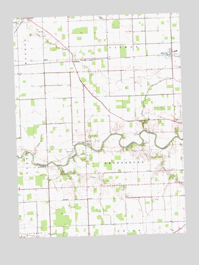
Miller City, OH USGS Topographic Map
Click on map above to begin viewing in our Map Viewer.

This topographic map contains these locations and features:
Feature Name Type Latitude Longitude GNIS ID View Map
AvisPopulated PlaceN41.0209°W84.1691°1064363View Map
Bear CreekStreamN41.0517°W84.1549°1037719View Map
Center School (historical)SchoolN41.1228°W84.1694°1050089View Map
Country Acres Golf CourseLocaleN41.0295°W84.1933°1050088View Map
CroswellPopulated PlaceN41.0209°W84.1977°1061010View Map
CubaPopulated PlaceN41.0534°W84.1983°1070727View Map
Deer CreekStreamN41.0406°W84.2188°1039651View Map
Dornington Post Office (historical)Post OfficeN41.0209°W84.2166°2044284View Map
DornintonPopulated PlaceN41.0206°W84.2172°1064549View Map
Duck RunStreamN41.0470°W84.2386°1039849View Map
Forest Grove ChurchChurchN41.0642°W84.1672°1040558View Map
HectorPopulated PlaceN41.1003°W84.2277°1041455View Map
Hector Post Office (historical)Post OfficeN41.1000°W84.2277°2056189View Map
KiefervillePopulated PlaceN41.1003°W84.2066°1064932View Map
Kieferville CemeteryCemeteryN41.1028°W84.2049°1071349View Map
Kieferville Post Office (historical)Post OfficeN41.1000°W84.2069°2056193View Map
Miller CityPopulated PlaceN41.1028°W84.1313°1065027View Map
Miller City CutoffCanalN41.0809°W84.1502°1057848View Map
Miller City Volunteer Fire DepartmentBuildingN41.1031°W84.1319°2549654View Map
Miller Elementary SchoolSchoolN41.1034°W84.1283°1050091View Map
Miller High SchoolSchoolN41.1037°W84.1277°1050092View Map
Mount Pleasant ChurchChurchN41.0398°W84.2286°1043618View Map
Myers CemeteryCemeteryN41.0518°W84.1542°1043756View Map
Myers CornersLocaleN41.0645°W84.1599°1050090View Map
Putnam CountyCivilN41.0221°W84.1317°1074081View Map
Saint Isadores Catholic ChurchChurchN41.0537°W84.1986°1071355View Map
Saint Isadores CemeteryCemeteryN41.0537°W84.2002°1084384View Map
Saint Nicholas Catholic ChurchChurchN41.1034°W84.1294°1071363View Map
Saint Nicholas CemeteryCemeteryN41.1023°W84.1283°1071364View Map
Township of GreensburgCivilN41.0426°W84.1693°1086858View Map
Township of PalmerCivilN41.1225°W84.1699°1086865View Map
Varner CemeteryCemeteryN41.0478°W84.2080°1047429View Map
Varner CemeteryCemeteryN41.0570°W84.1577°1070974View Map
Verhoff Airport (historical)AirportN41.0736°W84.2083°1082625View Map
Village of Miller CityCivilN41.1035°W84.1309°2399356View Map
Wing CemeteryCemeteryN41.1166°W84.2275°1048002View Map
WistermanPopulated PlaceN41.1237°W84.2377°1056577View Map
Wisterman Post Office (historical)Post OfficeN41.1237°W84.2374°2056212View Map

Note: Coordinates in the location and feature list above are referenced to NAD83 datum.


Copyright (C) 2008-2025 Ryan Niemi / Sunset Dynamics ... All Rights Reserved