TopoQuest Logo
Do you find TopoQuest useful?
Help keep TopoQuest running and adding new maps/features by donating!
Bitcoin:  19c7KJd3qBynnjoSw5npx9KScwjBe4ifkT
Litecoin:  LXs6TkuXGGXo1vDsWCkWVdjQX94eUKd6ui
Home View Maps Find Maps Find Places Resources & Links


Continental, Ohio Topographic Map

USGS Map Title: Continental, OH
USGS Map MRC: 41084A3
DRG (GeoTIFF) Download: o41084a3.tif


Neighboring USGS Topographic Map Quads:


  Junction, OH  
41084B4
 

  Ayersville, OH  
41084B3
 

  New Bavaria, OH  
41084B2
 

  Oakwood, OH  
41084A4
 

  Continental, OH  
41084A3
 

  Miller City, OH  
41084A2
 

  Wetsel, OH  
40084H4
 

  Ottoville, OH  
40084H3
 

  Kalida, OH  
40084H2


Map MRC Location:

N42°
W85°
N42°
W84°
H8 H7 H6 H5 H4 H3 H2 H1
G8 G7 G6 G5 G4 G3 G2 G1
F8 F7 F6 F5 F4 F3 F2 F1
E8 E7 E6 E5 E4 E3 E2 E1
D8 D7 D6 D5 D4 D3 D2 D1
C8 C7 C6 C5 C4 C3 C2 C1
B8 B7 B6 B5 B4 B3 B2 B1
A8 A7 A6 A5 A4 A3 A2 A1
N41°
W85°
N41°
W84°

Continental, OH USGS 1:24K Topographic Map Preview:
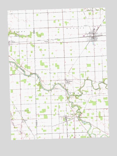
Continental, OH USGS Topographic Map
Click on map above to begin viewing in our Map Viewer.

This topographic map contains these locations and features:
Feature Name Type Latitude Longitude GNIS ID View Map
Blanchard RiverStreamN41.0414°W84.2994°1065925View Map
CascadePopulated PlaceN41.0209°W84.2888°1075188View Map
Cascade CemeteryCemeteryN41.0170°W84.2872°1038853View Map
Cascade Post Office (historical)Post OfficeN41.0209°W84.2897°2044279View Map
Casoade ParkParkN41.0195°W84.2866°1038861View Map
CloverdalePopulated PlaceN41.0209°W84.3044°1079575View Map
Cloverdale Post OfficePost OfficeN41.0209°W84.3041°2043378View Map
Comer CemeteryCemeteryN41.0031°W84.2649°1039284View Map
ContinentalPopulated PlaceN41.1003°W84.2663°1056835View Map
Continental Fire DepartmentBuildingN41.0980°W84.2656°2550395View Map
Continental High SchoolSchoolN41.1045°W84.2649°1050087View Map
Continental Police DepartmentBuildingN41.0978°W84.2656°2732447View Map
Continental Post OfficePost OfficeN41.1000°W84.2666°2043366View Map
Dickey CemeteryCemeteryN41.0476°W84.2605°1039703View Map
DupontPopulated PlaceN41.0564°W84.3044°1048670View Map
Dupont Post OfficePost OfficeN41.0570°W84.3041°2044287View Map
East MandalePopulated PlaceN41.0237°W84.3424°1062462View Map
Etties-Burg (historical)Populated PlaceN41.0931°W84.3608°1961007View Map
Fairview CemeteryCemeteryN41.0523°W84.3183°1040336View Map
Franconia (historical)Populated PlaceN41.0423°W84.3022°1063577View Map
Franconia CemeteryCemeteryN41.0395°W84.2935°1040644View Map
Franconia Post Office (historical)Post OfficeN41.0431°W84.3027°2043341View Map
HamerLocaleN41.0020°W84.3455°1065494View Map
HartsburgPopulated PlaceN41.0925°W84.3244°1056316View Map
Hartsburg Post Office (historical)Post OfficeN41.0931°W84.3249°2043343View Map
Hartsburg United Methodist ChurchChurchN41.0928°W84.3236°1071346View Map
Holden CemeteryCemeteryN41.0006°W84.2736°1041663View Map
Huntstown (historical)Populated PlaceN41.0053°W84.3036°1050086View Map
Huntstown Post Office (historical)Post OfficeN41.0056°W84.3041°2056190View Map
Lapp DitchCanalN41.0226°W84.3008°1042419View Map
MandalePopulated PlaceN41.0181°W84.3599°1062503View Map
Mandale Church of Christ in Christian UnionChurchN41.0170°W84.3588°1062504View Map
Mandale Post Office (historical)Post OfficeN41.0181°W84.3597°2042136View Map
Mobile ManorPopulated PlaceN41.1031°W84.2633°2648361View Map
Monroe CemeteryCemeteryN41.1231°W84.2658°1043443View Map
Myers CemeteryCemeteryN41.0170°W84.2874°1071351View Map
New Bethany CemeteryCemeteryN41.0484°W84.3138°1043823View Map
Oak Grove CemeteryCemeteryN41.0638°W84.3465°1961039View Map
Oakwood Volunteer Fire and Rescue DepartmentBuildingN41.0946°W84.3733°2550436View Map
Pear Meadows FarmLocaleN41.0875°W84.3536°2564648View Map
Prairie ChapelChurchN41.0998°W84.3616°1044742View Map
Prairie Chapel CemeteryCemeteryN41.1000°W84.3624°1961054View Map
South Mount Zion ChurchChurchN41.0531°W84.2561°1046485View Map
Township of MonroeCivilN41.1219°W84.2848°1086862View Map
Township of PerryCivilN41.0418°W84.2845°1086866View Map
Van Ham DairyLocaleN41.0761°W84.2822°2564647View Map
Village of CloverdaleCivilN41.0192°W84.3037°2398584View Map
Village of ContinentalCivilN41.0997°W84.2692°2398619View Map
Village of DupontCivilN41.0547°W84.3010°2398760View Map

Note: Coordinates in the location and feature list above are referenced to NAD83 datum.


Copyright (C) 2008-2025 Ryan Niemi / Sunset Dynamics ... All Rights Reserved