TopoQuest Logo
Do you find TopoQuest useful?
Help keep TopoQuest running and adding new maps/features by donating!
Bitcoin:  19c7KJd3qBynnjoSw5npx9KScwjBe4ifkT
Litecoin:  LXs6TkuXGGXo1vDsWCkWVdjQX94eUKd6ui
Home View Maps Find Maps Find Places Resources & Links


Rowe Creek, Oregon Topographic Map

USGS Map Title: Rowe Creek, OR
USGS Map MRC: 44120G2
DRG (GeoTIFF) Download: o44120g2.tif


Neighboring USGS Topographic Map Quads:


  Porcupine Butte, OR  
44120H3
 

  Fossil South, OR  
44120H2
 

  Kinzua, OR  
44120H1
 

  Jennies Peak, OR  
44120G3
 

  Rowe Creek, OR  
44120G2
 

  Service Creek, OR  
44120G1
 

  Painted Hills, OR  
44120F3
 

  Sutton Mountain, OR  
44120F2
 

  Toney Butte, OR  
44120F1


Map MRC Location:

N45°
W121°
N45°
W120°
H8 H7 H6 H5 H4 H3 H2 H1
G8 G7 G6 G5 G4 G3 G2 G1
F8 F7 F6 F5 F4 F3 F2 F1
E8 E7 E6 E5 E4 E3 E2 E1
D8 D7 D6 D5 D4 D3 D2 D1
C8 C7 C6 C5 C4 C3 C2 C1
B8 B7 B6 B5 B4 B3 B2 B1
A8 A7 A6 A5 A4 A3 A2 A1
N44°
W121°
N44°
W120°

Rowe Creek, OR USGS 1:24K Topographic Map Preview:
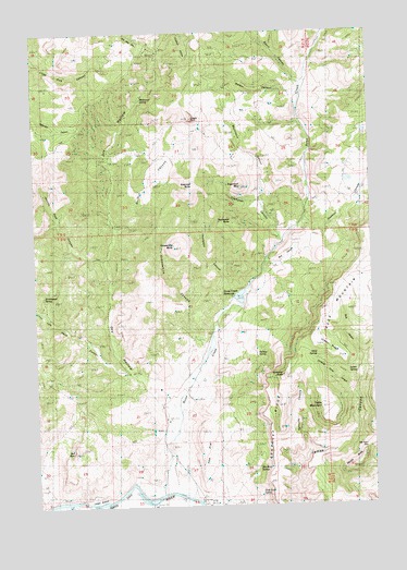
Rowe Creek, OR USGS Topographic Map
Click on map above to begin viewing in our Map Viewer.

This topographic map contains these locations and features:
Feature Name Type Latitude Longitude GNIS ID View Map
Alkali SpringsSpringN44.7885°W120.1474°1116871View Map
Beard CanyonValleyN44.8624°W120.1536°1117403View Map
Beckley SpringSpringN44.7891°W120.1691°1117471View Map
Bull CanyonValleyN44.8143°W120.1656°1118270View Map
Craggy RockPillarN44.8521°W120.1922°1119498View Map
Crosswhite ButteSummitN44.8187°W120.2000°1119578View Map
Crosswhite CanyonValleyN44.7901°W120.1903°1119579View Map
Dedman CanyonValleyN44.8235°W120.1528°1119779View Map
Dry HollowValleyN44.7787°W120.2031°1120165View Map
Griffin CanyonValleyN44.8226°W120.2209°1121430View Map
Homestead SpringSpringN44.8056°W120.2480°1121950View Map
Jennies Peak CanyonValleyN44.8143°W120.2272°1122405View Map
Jumbo RidgeRidgeN44.7910°W120.1431°1122552View Map
Jumbo SpringsSpringN44.7858°W120.1358°1122553View Map
Kentucky ButteSummitN44.7841°W120.1596°1122698View Map
Kentucky CanyonValleyN44.7646°W120.1514°1122699View Map
Kentucky RidgeRidgeN44.7707°W120.1614°1122701View Map
Kotzman ButteSummitN44.8340°W120.1922°1122838View Map
Lambing Camp CanyonValleyN44.7793°W120.1345°1122927View Map
Left Hand CanyonValleyN44.7843°W120.2178°1123034View Map
Liberty BottomFlatN44.7518°W120.2297°1161416View Map
Mathieson SpringSpringN44.8574°W120.2111°1123836View Map
Mortimore CanyonValleyN44.8315°W120.1675°1124376View Map
Red RockSummitN44.7649°W120.2381°1125898View Map
Rim Rock SpringsSpringN44.7590°W120.1702°1133254View Map
Rock CanyonValleyN44.7890°W120.1308°1126138View Map
Rock MountainRidgeN44.8074°W120.1400°1126193View Map
Rowe CreekStreamN44.7535°W120.2050°1126341View Map
Rowe Creek DamDamN44.8041°W120.1764°1133667View Map
Rowe Creek ReservoirReservoirN44.8051°W120.1751°1126342View Map
Shell Rock SpringSpringN44.7528°W120.1686°1159086View Map
Squaw ButteSummitN44.7596°W120.1342°1127475View Map
Sugarloaf CanyonValleyN44.8190°W120.1600°1127698View Map
Sugarloaf MountainSummitN44.8340°W120.1747°1127702View Map
Sutton RanchLocaleN44.7729°W120.2025°1127778View Map
Table MountainSummitN44.7760°W120.1464°1127863View Map
Tap Horn GapGapN44.7649°W120.1292°1127893View Map
The FlatFlatN44.7610°W120.1892°1127966View Map
Thompson ButteSummitN44.8256°W120.1787°1136825View Map
Thompson CanyonValleyN44.8046°W120.1797°1128025View Map
Walker CanyonValleyN44.8576°W120.1550°1128584View Map

Note: Coordinates in the location and feature list above are referenced to NAD83 datum.


Copyright (C) 2008-2025 Ryan Niemi / Sunset Dynamics ... All Rights Reserved