TopoQuest Logo
Do you find TopoQuest useful?
Help keep TopoQuest running and adding new maps/features by donating!
Bitcoin:  19c7KJd3qBynnjoSw5npx9KScwjBe4ifkT
Litecoin:  LXs6TkuXGGXo1vDsWCkWVdjQX94eUKd6ui
Home View Maps Find Maps Find Places Resources & Links


Smithdale, Mississippi Topographic Map

USGS Map Title: Smithdale, MS
USGS Map MRC: 31090C6
DRG (GeoTIFF) Download: o31090c6.tif


Neighboring USGS Topographic Map Quads:


  Bude, MS  
31090D7
 

  Little Springs, MS  
31090D6
 

  West Lincoln, MS  
31090D5
 

  Busy Corner, MS  
31090C7
 

  Smithdale, MS  
31090C6
 

  Auburn, MS  
31090C5
 

  Liberty, MS  
31090B7
 

  Peoria, MS  
31090B6
 

  Lake Tangipahoa, MS  
31090B5


Map MRC Location:

N32°
W91°
N32°
W90°
H8 H7 H6 H5 H4 H3 H2 H1
G8 G7 G6 G5 G4 G3 G2 G1
F8 F7 F6 F5 F4 F3 F2 F1
E8 E7 E6 E5 E4 E3 E2 E1
D8 D7 D6 D5 D4 D3 D2 D1
C8 C7 C6 C5 C4 C3 C2 C1
B8 B7 B6 B5 B4 B3 B2 B1
A8 A7 A6 A5 A4 A3 A2 A1
N31°
W91°
N31°
W90°

Smithdale, MS USGS 1:24K Topographic Map Preview:
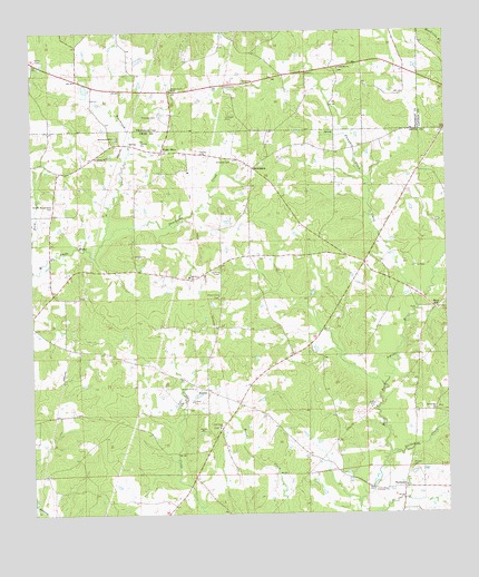
Smithdale, MS USGS Topographic Map
Click on map above to begin viewing in our Map Viewer.

This topographic map contains these locations and features:
Feature Name Type Latitude Longitude GNIS ID View Map
Butler CemeteryCemeteryN31.2504°W90.6323°685221View Map
Butler School (historical)SchoolN31.3210°W90.6634°685222View Map
Calvary CemeteryCemeteryN31.3393°W90.7298°685223View Map
Calvary ChurchChurchN31.3424°W90.7307°667928View Map
Church of GodChurchN31.3066°W90.6937°668453View Map
Church of God CemeteryCemeteryN31.3060°W90.6937°685235View Map
Cruise CemeteryCemeteryN31.3371°W90.7465°685242View Map
Cupit CemeteryCemeteryN31.3018°W90.6815°685243View Map
Fenn CemeteryCemeteryN31.3063°W90.6362°685263View Map
Ferd CreekStreamN31.3130°W90.7495°693207View Map
Flowers CemeteryCemeteryN31.3174°W90.6420°685264View Map
Freeman CemeteryCemeteryN31.3063°W90.6645°685267View Map
Gerald CemeteryCemeteryN31.3132°W90.6384°686106View Map
Good Hope CemeteryCemeteryN31.2724°W90.6943°685278View Map
Good Hope ChurchChurchN31.2724°W90.6940°670468View Map
Gordon CemeteryCemeteryN31.2624°W90.6362°670533View Map
Gordon CreekStreamN31.2652°W90.6423°670536View Map
Hampton Burris CemeteryCemeteryN31.2796°W90.6357°685286View Map
Harrell-Kirkland CemeteryCemeteryN31.3160°W90.6798°685289View Map
HustlerPopulated PlaceN31.2821°W90.6976°691954View Map
Jackson School (historical)SchoolN31.3330°W90.6362°685303View Map
Lumpkin CemeteryCemeteryN31.3535°W90.6901°672957View Map
Mars HillPopulated PlaceN31.3032°W90.6282°673145View Map
Mars Hill CemeteryCemeteryN31.3052°W90.6257°685322View Map
Mars Hill Volunteer Fire DepartmentBuildingN31.3027°W90.6288°2668044View Map
Marsalis CemeteryCemeteryN31.2596°W90.6568°685323View Map
Martin Lake DamDamN31.3602°W90.7351°680684View Map
McDowell CemeteryCemeteryN31.2618°W90.6993°685325View Map
Moore CemeteryCemeteryN31.2710°W90.7184°685337View Map
Mount OlivePopulated PlaceN31.3438°W90.7101°692088View Map
Mount Olive Baptist ChurchChurchN31.3441°W90.7095°685342View Map
Mount Olive CemeteryCemeteryN31.3435°W90.7101°685343View Map
Oak Grove Baptist ChurchChurchN31.3113°W90.7026°675022View Map
Oak Grove CemeteryCemeteryN31.3599°W90.7062°707596View Map
Oak Grove CemeteryCemeteryN31.3118°W90.7023°685358View Map
Oak Grove Primitive Baptist ChurchChurchN31.3602°W90.7068°675023View Map
Old Good Hope CemeteryCemeteryN31.2810°W90.6909°685362View Map
Old SmithdaleLocaleN31.3093°W90.6395°692351View Map
Pate-Gardner CemeteryCemeteryN31.2954°W90.6334°685367View Map
Pumpkin Patch CreekStreamN31.3074°W90.6337°676416View Map
Reeves CemeteryCemeteryN31.2582°W90.7473°685374View Map
Salem CemeteryCemeteryN31.2524°W90.7076°685386View Map
Salem Church (historical)ChurchN31.2521°W90.7076°685387View Map
Shackaloa CreekStreamN31.3216°W90.7276°677534View Map
SmithdalePopulated PlaceN31.3396°W90.6829°677939View Map
Smithdale Post OfficePost OfficeN31.3397°W90.6826°2768824View Map
Smithdale Volunteer Fire DepartmentBuildingN31.3093°W90.7410°2667925View Map
Smiths Store (historical)LocaleN31.3335°W90.6445°685393View Map
Spring Hill Baptist ChurchChurchN31.2768°W90.6287°678108View Map
Spring Hill CemeteryCemeteryN31.2771°W90.6284°685397View Map
Temble Hill ChurchChurchN31.3655°W90.6568°678616View Map
Temple Hill CemeteryCemeteryN31.3652°W90.6568°707608View Map
Terry CemeteryCemeteryN31.3627°W90.6848°678646View Map
ThompsonPopulated PlaceN31.2568°W90.6382°692264View Map
Thompson Baptist ChurchChurchN31.2571°W90.6379°685410View Map
Thompson CemeteryCemeteryN31.2579°W90.6376°685411View Map
Thompson CemeteryCemeteryN31.2593°W90.6562°685412View Map
Thornton CemeteryCemeteryN31.3532°W90.7115°678725View Map
Wactor CemeteryCemeteryN31.3321°W90.7176°685422View Map
Weathersby CemeteryCemeteryN31.3010°W90.6590°685427View Map
Westbrook CreekStreamN31.3218°W90.7279°679535View Map
Westbrook Memorial CemeteryCemeteryN31.3468°W90.7243°679536View Map
Williams CemeteryCemeteryN31.3413°W90.6895°679704View Map
Williams Mill (historical)LocaleN31.3421°W90.6904°685436View Map
Wroten and Carraway CemeteryCemeteryN31.3296°W90.7445°679897View Map
Young CemeteryCemeteryN31.3435°W90.6987°679963View Map

Note: Coordinates in the location and feature list above are referenced to NAD83 datum.


Copyright (C) 2008-2025 Ryan Niemi / Sunset Dynamics ... All Rights Reserved