TopoQuest Logo
Do you find TopoQuest useful?
Help keep TopoQuest running and adding new maps/features by donating!
Bitcoin:  19c7KJd3qBynnjoSw5npx9KScwjBe4ifkT
Litecoin:  LXs6TkuXGGXo1vDsWCkWVdjQX94eUKd6ui
Home View Maps Find Maps Find Places Resources & Links


Sparta, Georgia Topographic Map

USGS Map Title: Sparta, GA
USGS Map MRC: 33082C8
DRG (GeoTIFF) Download: o33082c8.tif


Neighboring USGS Topographic Map Quads:


  White Plains, GA  
33083D1
 

  Sparta NW, GA  
33082D8
 

  Sparta NE, GA  
33082D7
 

  Shoulderbone, GA  
33083C1
 

  Sparta, GA  
33082C8
 

  Jewell, GA  
33082C7
 

  Devereux, GA  
33083B1
 

  Warthen NW, GA  
33082B8
 

  Warthen NE, GA  
33082B7


Map MRC Location:

N34°
W83°
N34°
W82°
H8 H7 H6 H5 H4 H3 H2 H1
G8 G7 G6 G5 G4 G3 G2 G1
F8 F7 F6 F5 F4 F3 F2 F1
E8 E7 E6 E5 E4 E3 E2 E1
D8 D7 D6 D5 D4 D3 D2 D1
C8 C7 C6 C5 C4 C3 C2 C1
B8 B7 B6 B5 B4 B3 B2 B1
A8 A7 A6 A5 A4 A3 A2 A1
N33°
W83°
N33°
W82°

Sparta, GA USGS 1:24K Topographic Map Preview:
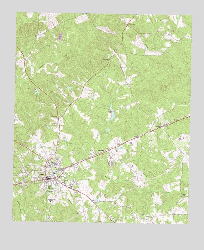
Sparta, GA USGS Topographic Map
Click on map above to begin viewing in our Map Viewer.

This topographic map contains these locations and features:
Feature Name Type Latitude Longitude GNIS ID View Map
Amos Brantley Family CemeteryCemeteryN33.3107°W82.9110°1985779View Map
Armstrong Cork Lake DamDamN33.3585°W82.9682°336420View Map
Armstrong LakeReservoirN33.3610°W82.9681°336421View Map
Beaver Lookout TowerTowerN33.3707°W82.9201°344189View Map
Bethel CemeteryCemeteryN33.2665°W82.8776°348191View Map
Bethel ChurchChurchN33.2668°W82.8785°354608View Map
Bethel School (historical)SchoolN33.2976°W82.8863°348192View Map
Britt CemeteryCemeteryN33.3089°W82.9693°348195View Map
Brooking Family CemeteryCemeteryN33.2821°W82.9001°1985780View Map
Brown LakeReservoirN33.3302°W82.9611°340647View Map
Brown Lake DamDamN33.3301°W82.9615°340646View Map
Browns LakeReservoirN33.3118°W82.9299°336429View Map
Browns Lake DamDamN33.3118°W82.9299°336428View Map
Browns LakesLakeN33.3153°W82.9301°311899View Map
Christ Healing TempleChurchN33.2929°W82.9890°348198View Map
City of SpartaCivilN33.2767°W82.9706°2405504View Map
Coleman LakeReservoirN33.2944°W82.9252°341618View Map
Coleman Lake DamDamN33.2951°W82.9249°341617View Map
Covey Rise Farm CemeteryCemeteryN33.3641°W82.8891°1985791View Map
CulvertonPopulated PlaceN33.3085°W82.8951°355405View Map
Culverton CemeteryCemeteryN33.3096°W82.9007°348199View Map
Culverton ChurchChurchN33.3093°W82.9010°348200View Map
Dixon Family CemeteryCemeteryN33.2824°W82.9721°1985798View Map
Granite HillSummitN33.2924°W82.9354°331847View Map
Guill CemeteryCemeteryN33.2640°W82.9554°348207View Map
Hancock Central High SchoolSchoolN33.3009°W82.9699°315080View Map
Hancock Central Middle SchoolSchoolN33.3004°W82.9700°2545812View Map
Hancock County Crossroads Alternative SchoolSchoolN33.3007°W82.9704°2545813View Map
Hancock County JailBuildingN33.2795°W82.9755°2734083View Map
Hancock County Sheriff's DepartmentBuildingN33.2795°W82.9753°2733533View Map
Hancock Gospel CenterChurchN33.2618°W82.9424°348210View Map
Hancock Memorial HospitalHospitalN33.2690°W82.9714°348211View Map
Hancock Memorial Hospital HeliportAirportN33.2682°W82.9718°351908View Map
Holsey Memorial Cemetery Number 1CemeteryN33.2849°W82.9651°1985881View Map
Holsey Memorial Cemetery Number 2CemeteryN33.2786°W82.9633°1985815View Map
Holsey Memorial Cemetery Number 3CemeteryN33.2779°W82.9640°1985816View Map
Holseys Memorial ChurchChurchN33.2788°W82.9640°315585View Map
House of God ChurchChurchN33.2901°W82.9929°348216View Map
Ingraham Family CemeteryCemeteryN33.2726°W82.9927°1985819View Map
Ingrams College (historical)SchoolN33.2715°W82.9904°348218View Map
John Hancock AcademySchoolN33.2625°W82.9725°316131View Map
M E Lewis Elementary SchoolSchoolN33.2982°W82.9700°348224View Map
Mount Zion Baptist CemeteryCemeteryN33.3607°W82.9979°1985883View Map
New Beulah ChurchChurchN33.3463°W82.9338°319291View Map
Northside ChurchChurchN33.2832°W82.9857°348237View Map
Old Indian CemeteryCemeteryN33.2812°W82.9010°348239View Map
Pleasant Grove ChurchChurchN33.3124°W82.9699°320831View Map
Power of God ChurchChurchN33.2954°W82.9938°348248View Map
Saint Lewis CemeteryCemeteryN33.3021°W82.9110°348255View Map
Saint Louis ChurchChurchN33.3021°W82.9115°322146View Map
Saint Louis School (historical)SchoolN33.3021°W82.9113°348256View Map
Saint Mark African Methodist Episcopal Church CemeteryCemeteryN33.2799°W82.9932°1985860View Map
Saint Marks ChurchChurchN33.2796°W82.9926°322183View Map
Smyrna ChurchChurchN33.3538°W82.9290°323179View Map
Smyrna Methodist Church CemeteryCemeteryN33.3526°W82.9295°1985853View Map
SpartaPopulated PlaceN33.2757°W82.9763°323330View Map
Sparta Catholic CemeteryCemeteryN33.2715°W82.9760°1985854View Map
Sparta CemeteryCemeteryN33.2787°W82.9735°348261View Map
Sparta ChurchChurchN33.3188°W82.9610°348262View Map
Sparta DivisionCivilN33.2991°W82.9853°1936552View Map
Sparta Hancock Fire Department Station 1BuildingN33.2774°W82.9748°2603762View Map
Sparta High SchoolSchoolN33.2768°W82.9674°348264View Map
Sparta Historic DistrictParkN33.2754°W82.9763°348265View Map
Sparta Police DepartmentBuildingN33.2754°W82.9752°2733683View Map
Sticks School (historical)SchoolN33.3121°W82.9696°348269View Map
Sunshine (historical)Populated PlaceN33.2988°W82.9196°348270View Map
Tabernacle ChurchChurchN33.2738°W82.9638°323877View Map
Turner ChurchChurchN33.3093°W82.8960°324409View Map
Twomile CreekStreamN33.2699°W82.9007°324462View Map
Wallers Store (historical)LocaleN33.3507°W82.9296°348275View Map
WHAN-FM (Sparta)TowerN33.2818°W82.9938°352783View Map

Note: Coordinates in the location and feature list above are referenced to NAD83 datum.


Copyright (C) 2008-2025 Ryan Niemi / Sunset Dynamics ... All Rights Reserved