TopoQuest Logo
Do you find TopoQuest useful?
Help keep TopoQuest running and adding new maps/features by donating!
Bitcoin:  19c7KJd3qBynnjoSw5npx9KScwjBe4ifkT
Litecoin:  LXs6TkuXGGXo1vDsWCkWVdjQX94eUKd6ui
Home View Maps Find Maps Find Places Resources & Links


Phillips Lake, Oregon Topographic Map

USGS Map Title: Phillips Lake, OR
USGS Map MRC: 44118F1
DRG (GeoTIFF) Download: o44118f1.tif


Neighboring USGS Topographic Map Quads:


  Bourne, OR  
44118G2
 

  Elkhorn Peak, OR  
44118G1
 

  Wingville, OR  
44117G8
 

  Sumpter, OR  
44118F2
 

  Phillips Lake, OR  
44118F1
 

  Blue Canyon, OR  
44117F8
 

  Unity Reservoir, OR  
44118E2
 

  Beaverdam Creek, OR  
44118E1
 

  Brannan Gulch, OR  
44117E8


Map MRC Location:

N45°
W119°
N45°
W118°
H8 H7 H6 H5 H4 H3 H2 H1
G8 G7 G6 G5 G4 G3 G2 G1
F8 F7 F6 F5 F4 F3 F2 F1
E8 E7 E6 E5 E4 E3 E2 E1
D8 D7 D6 D5 D4 D3 D2 D1
C8 C7 C6 C5 C4 C3 C2 C1
B8 B7 B6 B5 B4 B3 B2 B1
A8 A7 A6 A5 A4 A3 A2 A1
N44°
W119°
N44°
W118°

Phillips Lake, OR USGS 1:24K Topographic Map Preview:
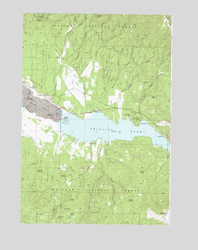
Phillips Lake, OR USGS Topographic Map
Click on map above to begin viewing in our Map Viewer.

This topographic map contains these locations and features:
Feature Name Type Latitude Longitude GNIS ID View Map
Adams SpringSpringN44.6535°W118.0912°1116772View Map
Alder CreekStreamN44.7227°W118.0924°1116827View Map
Alder Loop SpringSpringN44.7487°W118.0635°1116836View Map
Baboon CreekStreamN44.7463°W118.1052°1117119View Map
Birch CreekStreamN44.7035°W118.0561°1117718View Map
Black MountainSummitN44.6310°W118.0033°1117762View Map
Bridge CreekStreamN44.6885°W118.0416°1118067View Map
Britten Post Office (historical)Post OfficeN44.6929°W118.0627°1164960View Map
Camp SpringSpringN44.6339°W118.0888°1118533View Map
Clear CreekStreamN44.6785°W118.0911°1118997View Map
Cook GulchValleyN44.6807°W118.0999°1140056View Map
Curry (historical)LocaleN44.6804°W118.0472°1699687View Map
Dean CreekStreamN44.6729°W118.0591°1119771View Map
Deer CreekStreamN44.6921°W118.0649°1119825View Map
Deer Creek Recreation SiteLocaleN44.7477°W118.1072°1119829View Map
East Fork Alder CreekStreamN44.7410°W118.0836°1120294View Map
East Fork Birch CreekStreamN44.7068°W118.0561°1120298View Map
East Fork Miners CreekStreamN44.7296°W118.0613°1120316View Map
Farmers DitchCanalN44.6846°W118.1052°1120635View Map
Hershal Post Office (historical)Post OfficeN44.6835°W118.0233°1164408View Map
Hudspeth Guard StationLocaleN44.6792°W118.0922°2082330View Map
Jack Wilson SpringSpringN44.6289°W118.0941°1122336View Map
Jeep Ride SpringSpringN44.6564°W118.0222°1122391View Map
Lake CreekStreamN44.7493°W118.1083°1122897View Map
Little Dean CreekStreamN44.6549°W118.0561°1123178View Map
Log Cabin SpringSpringN44.6394°W118.0797°1123346View Map
Mason Boat RampLocaleN44.6774°W118.0064°2700182View Map
McEwenPopulated PlaceN44.7007°W118.1047°1136524View Map
McEwen CemeteryCemeteryN44.7010°W118.1005°1867983View Map
McEwen Post Office (historical)Post OfficeN44.7007°W118.1047°1165605View Map
McHenry FlatFlatN44.6291°W118.0847°1123970View Map
McHenry SpringSpringN44.6308°W118.0838°1123971View Map
Miller Lane Recreation SiteLocaleN44.6757°W118.0816°1952986View Map
Miners CreekStreamN44.6921°W118.0647°1124236View Map
Minersville (historical)LocaleN44.7346°W118.0538°1131463View Map
Moody SpringSpringN44.6569°W118.1101°1124314View Map
Mowich Recreation SiteLocaleN44.6915°W118.0691°1167270View Map
Phillips LakeReservoirN44.6812°W118.0521°1132099View Map
Picnic SpringSpringN44.6306°W118.1120°1125360View Map
Pothole SpringSpringN44.6395°W118.0313°1125609View Map
Rockne GulchValleyN44.7474°W118.1080°1126224View Map
Smith CreekStreamN44.6913°W118.0613°1127118View Map
Southeast Shore Recreation SiteLocaleN44.6693°W118.0036°1952994View Map
Southwest Shore Phillips Reservoir Boat LaunchLocaleN44.6760°W118.0781°2700183View Map
Southwest Shore Recreation SiteLocaleN44.6757°W118.0816°1167269View Map
Stovepipe GulchValleyN44.7171°W118.0861°1127643View Map
Sumpter ValleyValleyN44.6904°W118.0919°1150649View Map
Sumpter Valley Railway - McEwen StationBuildingN44.7010°W118.1221°2699850View Map
Tibbs CreekStreamN44.7171°W118.0861°1759741View Map
Tope SpringSpringN44.7010°W118.0165°1128168View Map
Union CreekStreamN44.6877°W118.0233°1128411View Map
Union Creek Boat RampLocaleN44.6853°W118.0248°2700181View Map
Union Creek Recreation SiteLocaleN44.6882°W118.0263°1128413View Map
West Fork Birch CreekStreamN44.7068°W118.0555°1128836View Map

Note: Coordinates in the location and feature list above are referenced to NAD83 datum.


Copyright (C) 2008-2024 Ryan Niemi / Sunset Dynamics ... All Rights Reserved