TopoQuest Logo
Do you find TopoQuest useful?
Help keep TopoQuest running and adding new maps/features by donating!
Bitcoin:  19c7KJd3qBynnjoSw5npx9KScwjBe4ifkT
Litecoin:  LXs6TkuXGGXo1vDsWCkWVdjQX94eUKd6ui
Home View Maps Find Maps Find Places Resources & Links


Thomaston East, Alabama Topographic Map

USGS Map Title: Thomaston East, AL
USGS Map MRC: 32087C5
DRG (GeoTIFF) Download: o32087c5.tif


Neighboring USGS Topographic Map Quads:


  Gallion, AL  
32087D6
 

  Uniontown West, AL  
32087D5
 

  Uniontown East, AL  
32087D4
 

  Thomaston West, AL  
32087C6
 

  Thomaston East, AL  
32087C5
 

  Central Mills, AL  
32087C4
 

  Magnolia, AL  
32087B6
 

  Flatwood, AL  
32087B5
 

  Catherine, AL  
32087B4


Map MRC Location:

N33°
W88°
N33°
W87°
H8 H7 H6 H5 H4 H3 H2 H1
G8 G7 G6 G5 G4 G3 G2 G1
F8 F7 F6 F5 F4 F3 F2 F1
E8 E7 E6 E5 E4 E3 E2 E1
D8 D7 D6 D5 D4 D3 D2 D1
C8 C7 C6 C5 C4 C3 C2 C1
B8 B7 B6 B5 B4 B3 B2 B1
A8 A7 A6 A5 A4 A3 A2 A1
N32°
W88°
N32°
W87°

Thomaston East, AL USGS 1:24K Topographic Map Preview:
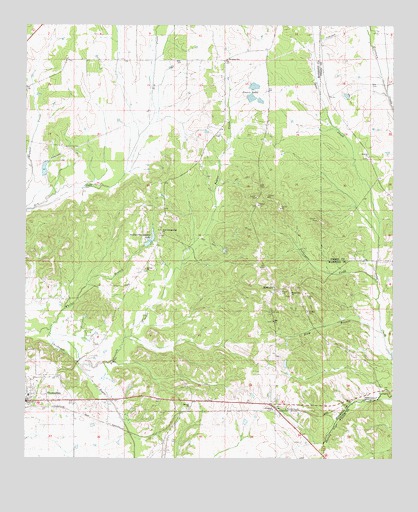
Thomaston East, AL USGS Topographic Map
Click on map above to begin viewing in our Map Viewer.

This topographic map contains these locations and features:
Feature Name Type Latitude Longitude GNIS ID View Map
Bethel Hill CemeteryCemeteryN32.2965°W87.5347°1867900View Map
Bethel Hill ChurchChurchN32.2971°W87.5347°114090View Map
Bush Store (historical)LocaleN32.3651°W87.5333°1730244View Map
Camp GroundLocaleN32.3132°W87.5797°137581View Map
ConsulPopulated PlaceN32.2643°W87.5400°156208View Map
Crenshaw (historical)Populated PlaceN32.2999°W87.6158°1730245View Map
Crocker DamDamN32.3318°W87.6217°130445View Map
Crocker LakeReservoirN32.3318°W87.6217°130444View Map
East Marengo Division (historical)CensusN32.2999°W87.6011°1934997View Map
Elam BranchStreamN32.2865°W87.5039°117897View Map
First Baptist ChurchChurchN32.2685°W87.6247°163200View Map
Flowers FieldAirportN32.2847°W87.5212°2676327View Map
Glovers CemeteryCemeteryN32.2646°W87.5694°1867914View Map
Glovers Primitive Baptist ChurchChurchN32.2646°W87.5692°119060View Map
Hebron Baptist ChurchChurchN32.3371°W87.5086°119925View Map
Jericho CemeteryCemeteryN32.3046°W87.5844°1867932View Map
Jericho ChurchChurchN32.3046°W87.5844°120860View Map
Kings (historical)Populated PlaceN32.2638°W87.5569°1730254View Map
Lyon (historical)Populated PlaceN32.3651°W87.5436°1730255View Map
McCorkle (historical)Populated PlaceN32.3649°W87.5747°1730256View Map
McKinleyPopulated PlaceN32.2985°W87.5403°122573View Map
Old White Hall (historical)Populated PlaceN32.2635°W87.6083°1730261View Map
Poplar CreekStreamN32.2768°W87.6056°155212View Map
Prairie Dam Number OneDamN32.3585°W87.5467°130485View Map
Prairie Lake Dam Number TwoDamN32.3551°W87.5483°130480View Map
Prairie Lake Number OneReservoirN32.3575°W87.5474°130486View Map
Prairie Lake Number TwoReservoirN32.3542°W87.5484°130479View Map
Prairie LakesReservoirN32.3542°W87.5484°125241View Map
Saint John ChurchChurchN32.3649°W87.5575°137667View Map
Saint John Elementary SchoolSchoolN32.3654°W87.5569°165524View Map
Stallworth DamDamN32.3085°W87.5833°130402View Map
Stallworths Shadow LakeReservoirN32.3132°W87.5821°153553View Map
Sugar Hill Plantation (historical)LocaleN32.3557°W87.5003°149864View Map
Thomaston Post OfficePost OfficeN32.2675°W87.6243°168668View Map
Thomaston Volunteer Fire Department Station 1BuildingN32.2681°W87.6235°2691139View Map
Town of ThomastonCivilN32.2683°W87.6237°2406729View Map
Turkeypen CreekStreamN32.3015°W87.5058°128178View Map
Whites BranchStreamN32.2874°W87.6164°128911View Map
Wootens (historical)Populated PlaceN32.2638°W87.5736°1730268View Map
Zion Campground CemeteryCemeteryN32.3149°W87.5786°1867934View Map
Zion Campground ChurchChurchN32.3151°W87.5786°129328View Map
Zion CemeteryCemeteryN32.2896°W87.5411°1867929View Map
Zion ChurchChurchN32.2899°W87.5411°129337View Map

Note: Coordinates in the location and feature list above are referenced to NAD83 datum.


Copyright (C) 2008-2024 Ryan Niemi / Sunset Dynamics ... All Rights Reserved