TopoQuest Logo
Do you find TopoQuest useful?
Help keep TopoQuest running and adding new maps/features by donating!
Bitcoin:  19c7KJd3qBynnjoSw5npx9KScwjBe4ifkT
Litecoin:  LXs6TkuXGGXo1vDsWCkWVdjQX94eUKd6ui
Home View Maps Find Maps Find Places Resources & Links


Millheim, Pennsylvania Topographic Map

USGS Map Title: Millheim, PA
USGS Map MRC: 40077H4
DRG (GeoTIFF) Download: o40077h4.tif


Neighboring USGS Topographic Map Quads:


  Beech Creek, PA  
41077A5
 

  Mill Hall, PA  
41077A4
 

  Loganton, PA  
41077A3
 

  Madisonburg, PA  
40077H5
 

  Millheim, PA  
40077H4
 

  Woodward, PA  
40077H3
 

  Spring Mills, PA  
40077G5
 

  Coburn, PA  
40077G4
 

  Weikert, PA  
40077G3


Map MRC Location:

N41°
W78°
N41°
W77°
H8 H7 H6 H5 H4 H3 H2 H1
G8 G7 G6 G5 G4 G3 G2 G1
F8 F7 F6 F5 F4 F3 F2 F1
E8 E7 E6 E5 E4 E3 E2 E1
D8 D7 D6 D5 D4 D3 D2 D1
C8 C7 C6 C5 C4 C3 C2 C1
B8 B7 B6 B5 B4 B3 B2 B1
A8 A7 A6 A5 A4 A3 A2 A1
N40°
W78°
N40°
W77°

Millheim, PA USGS 1:24K Topographic Map Preview:
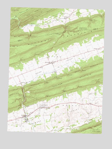
Millheim, PA USGS Topographic Map
Click on map above to begin viewing in our Map Viewer.

This topographic map contains these locations and features:
Feature Name Type Latitude Longitude GNIS ID View Map
AaronsburgPopulated PlaceN40.8998°W77.4533°1168362View Map
Aaronsburg Census Designated PlaceCensusN40.9042°W77.4513°2389113View Map
Aaronsburg Post OfficePost OfficeN40.8990°W77.4522°2779639View Map
Aaronsburg Reformed CemeteryCemeteryN40.9028°W77.4535°1184856View Map
Bear RunStreamN40.9853°W77.4875°1168933View Map
Bletz HollowValleyN40.9791°W77.4252°1169823View Map
Borough of MillheimCivilN40.8936°W77.4765°1215058View Map
Brooks Airport (historical)AirportN40.9501°W77.4164°1194142View Map
Brush MountainSummitN40.9428°W77.3869°1175171View Map
Cherry RunStreamN40.9887°W77.4944°1171667View Map
Colvey GapGapN40.9723°W77.4736°1172253View Map
Colvey NarrowsGapN40.9842°W77.4880°1196957View Map
Detweiler GapGapN40.9334°W77.4214°1173184View Map
Emmanuel ChurchChurchN40.9462°W77.4428°1174237View Map
Fairview CemeteryCemeteryN40.8876°W77.4864°1174495View Map
FiedlerPopulated PlaceN40.9048°W77.3908°1174736View Map
Fox GapGapN40.9278°W77.3825°1175092View Map
Gramley GapGapN40.9381°W77.4030°1175927View Map
Kreamer GapGapN40.9170°W77.4267°1178673View Map
Krouse GapGapN40.9253°W77.4497°1178693View Map
Little Kettle MountainSummitN40.9712°W77.4858°1179577View Map
Lose SchoolSchoolN40.8848°W77.3847°1196956View Map
Miles Township Fire Company 19BuildingN40.9458°W77.4460°2644839View Map
Milheim NarrowsGapN40.9142°W77.4786°1181111View Map
MillheimPopulated PlaceN40.8909°W77.4767°1181264View Map
Millheim Fire Company 18BuildingN40.8916°W77.4765°2645792View Map
Millheim Post OfficePost OfficeN40.8908°W77.4769°2779632View Map
Missionary ChurchChurchN40.9603°W77.3822°1181365View Map
Phillips CreekStreamN40.9073°W77.4775°1183673View Map
RebersburgPopulated PlaceN40.9445°W77.4450°1184745View Map
Rebersburg Census Designated PlaceCensusN40.9427°W77.4440°2389731View Map
Rebersburg Post OfficePost OfficeN40.9450°W77.4448°2772934View Map
RockvillePopulated PlaceN40.9401°W77.4594°1185333View Map
Rockville GapGapN40.9534°W77.4653°1185336View Map
Saint Pauls Union CemeteryCemeteryN40.9054°W77.3847°1186566View Map
Salem ChurchChurchN40.9020°W77.4497°1186850View Map
Schreckengast GapGapN40.9895°W77.3933°1187125View Map
Schroyer GapGapN40.9476°W77.4844°1187127View Map
Seven SpringSpringN40.9827°W77.4665°1202161View Map
SmulltonPopulated PlaceN40.9362°W77.4397°1187920View Map
Smullton GapGapN40.9298°W77.4344°1187921View Map
Spangler GapGapN40.9817°W77.4264°1188147View Map
Spring BankPopulated PlaceN40.9234°W77.4830°1217373View Map
State Game Lands Number 295ParkN40.9917°W77.4830°1208380View Map
Stover GapGapN40.9220°W77.4075°1188825View Map
Sugar ValleyValleyN40.9796°W77.4870°1188978View Map
The WineheadSummitN40.9620°W77.4678°1189452View Map
Township of LoganCivilN40.9975°W77.4179°1216266View Map
TylersvillePopulated PlaceN40.9906°W77.4250°1190051View Map
TylersvilleLocaleN40.9978°W77.4205°1212804View Map
Tylersville SpringSpringN40.9942°W77.4172°1202162View Map
Union CemeteryCemeteryN40.8895°W77.4836°1190112View Map
Union CemeteryCemeteryN40.9897°W77.4356°1190114View Map
Waterhouse GapGapN40.9115°W77.4489°1190676View Map
Willowby FarmLocaleN40.9089°W77.3917°2706887View Map
Wolf GapGapN40.9937°W77.3778°1191656View Map
Wolfs Chapel (historical)ChurchN40.9056°W77.4169°1196955View Map
Wolfs StorePopulated PlaceN40.9601°W77.3847°1191707View Map
Youngs GapGapN40.8809°W77.3875°1191918View Map

Note: Coordinates in the location and feature list above are referenced to NAD83 datum.


Copyright (C) 2008-2024 Ryan Niemi / Sunset Dynamics ... All Rights Reserved