TopoQuest Logo
Do you find TopoQuest useful?
Help keep TopoQuest running and adding new maps/features by donating!
Bitcoin:  19c7KJd3qBynnjoSw5npx9KScwjBe4ifkT
Litecoin:  LXs6TkuXGGXo1vDsWCkWVdjQX94eUKd6ui
Home View Maps Find Maps Find Places Resources & Links


Madisonburg, Pennsylvania Topographic Map

USGS Map Title: Madisonburg, PA
USGS Map MRC: 40077H5
DRG (GeoTIFF) Download: o40077h5.tif


Neighboring USGS Topographic Map Quads:


  Howard, PA  
41077A6
 

  Beech Creek, PA  
41077A5
 

  Mill Hall, PA  
41077A4
 

  Mingoville, PA  
40077H6
 

  Madisonburg, PA  
40077H5
 

  Millheim, PA  
40077H4
 

  Centre Hall, PA  
40077G6
 

  Spring Mills, PA  
40077G5
 

  Coburn, PA  
40077G4


Map MRC Location:

N41°
W78°
N41°
W77°
H8 H7 H6 H5 H4 H3 H2 H1
G8 G7 G6 G5 G4 G3 G2 G1
F8 F7 F6 F5 F4 F3 F2 F1
E8 E7 E6 E5 E4 E3 E2 E1
D8 D7 D6 D5 D4 D3 D2 D1
C8 C7 C6 C5 C4 C3 C2 C1
B8 B7 B6 B5 B4 B3 B2 B1
A8 A7 A6 A5 A4 A3 A2 A1
N40°
W78°
N40°
W77°

Madisonburg, PA USGS 1:24K Topographic Map Preview:
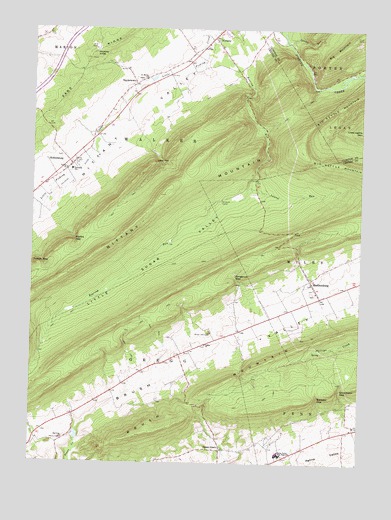
Madisonburg, PA USGS Topographic Map
Click on map above to begin viewing in our Map Viewer.

This topographic map contains these locations and features:
Feature Name Type Latitude Longitude GNIS ID View Map
Bear Hollow RunStreamN40.9725°W77.5392°2100385View Map
Big Kettle MountainSummitN40.9656°W77.5219°1169527View Map
Big MountainSummitN40.9940°W77.5108°1192133View Map
Boy School (historical)SchoolN40.9109°W77.5542°1196779View Map
Bressler GapGapN40.8942°W77.5153°1170205View Map
Brush ValleyValleyN40.8848°W77.6068°1170467View Map
Fulton GapGapN40.9328°W77.6206°1175332View Map
Gingerich GapGapN40.9284°W77.5472°1175632View Map
Green GrovePopulated PlaceN40.8790°W77.5517°1176067View Map
Hickory KnobSummitN40.9928°W77.6017°1176962View Map
HublersburgPopulated PlaceN40.9609°W77.6100°1177540View Map
Hublersburg Census Designated PlaceCensusN40.9623°W77.6072°2584471View Map
Krislund CampLocaleN40.9503°W77.5528°1178689View Map
Laurel RunStreamN40.9545°W77.5425°1178985View Map
Lees GapGapN40.9626°W77.5758°1179128View Map
Little Sugar ValleyValleyN40.9545°W77.5427°1179688View Map
MadisonburgPopulated PlaceN40.9262°W77.5172°1180186View Map
Madisonburg Census Designated PlaceCensusN40.9283°W77.5189°2390108View Map
Madisonburg Post OfficePost OfficeN40.9227°W77.5147°2773195View Map
Markle GapGapN40.9390°W77.6083°1180424View Map
Murray SchoolSchoolN40.8995°W77.5864°1196780View Map
NittanyPopulated PlaceN40.9976°W77.5561°1182480View Map
Nittany Census Designated PlaceCensusN40.9947°W77.5521°2584493View Map
Penns Cave AirportAirportN40.8901°W77.6026°1194132View Map
Penns Cave SpringSpringN40.8834°W77.6083°1202444View Map
Penns Valley Area High SchoolSchoolN40.8781°W77.5303°1183520View Map
Saint Marks ChurchChurchN40.9856°W77.5819°1186336View Map
Smithtown GapGapN40.8965°W77.5067°1187909View Map
SnydertownPopulated PlaceN40.9842°W77.5858°1187972View Map
Snydertown Census Designated PlaceCensusN40.9872°W77.5995°2584510View Map
Spring RunStreamN40.9965°W77.5278°1188272View Map
Township of WalkerCivilN40.9491°W77.6127°1216141View Map
Trinity ChurchChurchN40.9595°W77.6119°1189800View Map
Valley ChurchChurchN40.9090°W77.5581°1190292View Map
Walker Township Volunteer Fire Company 16 Main StationBuildingN40.9613°W77.6076°2645873View Map

Note: Coordinates in the location and feature list above are referenced to NAD83 datum.


Copyright (C) 2008-2024 Ryan Niemi / Sunset Dynamics ... All Rights Reserved