TopoQuest Logo
Do you find TopoQuest useful?
Help keep TopoQuest running and adding new maps/features by donating!
Bitcoin:  19c7KJd3qBynnjoSw5npx9KScwjBe4ifkT
Litecoin:  LXs6TkuXGGXo1vDsWCkWVdjQX94eUKd6ui
Home View Maps Find Maps Find Places Resources & Links


Theodosia, Missouri Topographic Map

USGS Map Title: Theodosia, MO
USGS Map MRC: 36092E6
DRG (GeoTIFF) Download: o36092e6.tif


Neighboring USGS Topographic Map Quads:


  Protem NE, MO  
36092F7
 

  Thornfield, MO  
36092F6
 

  Willhoit, MO  
36092F5
 

  Protem, MO  
36092E7
 

  Theodosia, MO  
36092E6
 

  Isabella, MO  
36092E5
 

  Peel, AR  
36092D7
 

  Cotter NW, AR  
36092D6
 

  Bull Shoals, AR  
36092D5


Map MRC Location:

N37°
W93°
N37°
W92°
H8 H7 H6 H5 H4 H3 H2 H1
G8 G7 G6 G5 G4 G3 G2 G1
F8 F7 F6 F5 F4 F3 F2 F1
E8 E7 E6 E5 E4 E3 E2 E1
D8 D7 D6 D5 D4 D3 D2 D1
C8 C7 C6 C5 C4 C3 C2 C1
B8 B7 B6 B5 B4 B3 B2 B1
A8 A7 A6 A5 A4 A3 A2 A1
N36°
W93°
N36°
W92°

Theodosia, MO USGS 1:24K Topographic Map Preview:
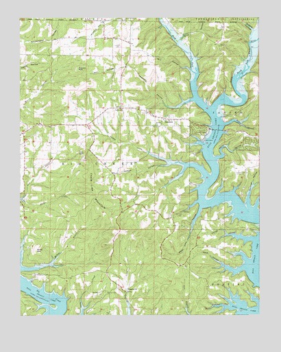
Theodosia, MO USGS Topographic Map
Click on map above to begin viewing in our Map Viewer.

This topographic map contains these locations and features:
Feature Name Type Latitude Longitude GNIS ID View Map
Barefoot School (historical)SchoolN36.6090°W92.7338°733825View Map
Briar HollowValleyN36.6153°W92.6668°749016View Map
Chain Link MountainSummitN36.5478°W92.7107°749324View Map
Coilep HollowValleyN36.5317°W92.6279°749404View Map
Cole HollowValleyN36.6223°W92.6252°749414View Map
Cowpen HollowValleyN36.5031°W92.6396°749504View Map
DugginsvillePopulated PlaceN36.5098°W92.6954°749744View Map
Dugginsville School (historical)SchoolN36.5103°W92.6791°733833View Map
Fairview CemeteryCemeteryN36.5167°W92.7396°749883View Map
Fairview School (historical)SchoolN36.5170°W92.7393°733827View Map
Friend Cemetery (historical)CemeteryN36.5859°W92.6468°734290View Map
Greene HollowValleyN36.6192°W92.6279°750148View Map
Guber HollowValleyN36.5801°W92.6432°750171View Map
Hart CemeteryCemeteryN36.5098°W92.7004°750245View Map
Heck HollowValleyN36.5201°W92.6335°750279View Map
Hicks CemeteryCemeteryN36.6134°W92.6999°750313View Map
Holt BaldSummitN36.5684°W92.7166°750372View Map
Ledbetter HollowValleyN36.5906°W92.6591°750674View Map
Long Run Volunteer Fire DepartmentBuildingN36.5295°W92.6580°2620817View Map
Lost Mine AirportAirportN36.5138°W92.6377°758661View Map
LutiePopulated PlaceN36.5873°W92.6977°734289View Map
Lutie CemeteryCemeteryN36.5828°W92.6710°750893View Map
Lutie School (historical)SchoolN36.5876°W92.6938°733829View Map
McVey BaldSummitN36.5273°W92.7418°751012View Map
McVey BranchStreamN36.5198°W92.7499°751013View Map
Mill HollowValleyN36.6034°W92.6610°751081View Map
Miller CreekStreamN36.5490°W92.7493°751093View Map
Mud Point School (historical)SchoolN36.5273°W92.6429°733832View Map
Neasby Ford (historical)CrossingN36.5198°W92.6271°734291View Map
Ocie Volunteer Fire DepartmentBuildingN36.5766°W92.7478°2620816View Map
Peacock BaldSummitN36.6037°W92.7196°751530View Map
Pelham HollowValleyN36.5637°W92.6716°751537View Map
Peter Cave HollowValleyN36.5456°W92.6560°751564View Map
Pond ForkStreamN36.5859°W92.6510°751695View Map
Rail HollowValleyN36.6048°W92.6943°751797View Map
Salem School (historical)SchoolN36.5498°W92.7477°733826View Map
Shiloh ChurchChurchN36.6131°W92.6457°752121View Map
Shiloh School (historical)SchoolN36.6178°W92.6441°733828View Map
Squirrel HollowValleyN36.5445°W92.6299°752332View Map
Stony Point School (historical)SchoolN36.5451°W92.6943°733831View Map
SundownPopulated PlaceN36.5665°W92.6368°1669607View Map
Sundown Census Designated PlaceCensusN36.5658°W92.6380°2587115View Map
TheodosiaPopulated PlaceN36.5828°W92.6760°752525View Map
Theodosia (historical)Populated PlaceN36.5767°W92.6482°733830View Map
Theodosia Hills Landing strip (historical)AirportN36.5617°W92.6382°754068View Map
Theodosia SchoolSchoolN36.5820°W92.6721°733834View Map
Theodosia Volunteer Fire DepartmentBuildingN36.5830°W92.6618°2621665View Map
Township of Big CreekCivilN36.5563°W92.7064°767125View Map
True Hope ChurchChurchN36.5867°W92.6966°752583View Map
Turkey CreekStreamN36.5640°W92.6694°752596View Map
Village of TheodosiaCivilN36.5807°W92.6638°2399969View Map
Wells HollowValleyN36.5656°W92.6482°752802View Map

Note: Coordinates in the location and feature list above are referenced to NAD83 datum.


Copyright (C) 2008-2024 Ryan Niemi / Sunset Dynamics ... All Rights Reserved