TopoQuest Logo
Do you find TopoQuest useful?
Help keep TopoQuest running and adding new maps/features by donating!
Bitcoin:  19c7KJd3qBynnjoSw5npx9KScwjBe4ifkT
Litecoin:  LXs6TkuXGGXo1vDsWCkWVdjQX94eUKd6ui
Home View Maps Find Maps Find Places Resources & Links


Coventry, Connecticut Topographic Map

USGS Map Title: Coventry, CT
USGS Map MRC: 41072G3
DRG (GeoTIFF) Download: o41072g3.tif


Neighboring USGS Topographic Map Quads:


  Ellington, CT  
41072H4
 

  Stafford Springs, CT  
41072H3
 

  Westford, CT  
41072H2
 

  Rockville, CT  
41072G4
 

  Coventry, CT  
41072G3
 

  Spring Hill, CT  
41072G2
 

  Marlborough, CT  
41072F4
 

  Columbia, CT  
41072F3
 

  Willimantic, CT  
41072F2


Map MRC Location:

N42°
W73°
N42°
W72°
H8 H7 H6 H5 H4 H3 H2 H1
G8 G7 G6 G5 G4 G3 G2 G1
F8 F7 F6 F5 F4 F3 F2 F1
E8 E7 E6 E5 E4 E3 E2 E1
D8 D7 D6 D5 D4 D3 D2 D1
C8 C7 C6 C5 C4 C3 C2 C1
B8 B7 B6 B5 B4 B3 B2 B1
A8 A7 A6 A5 A4 A3 A2 A1
N41°
W73°
N41°
W72°

Coventry, CT USGS 1:24K Topographic Map Preview:
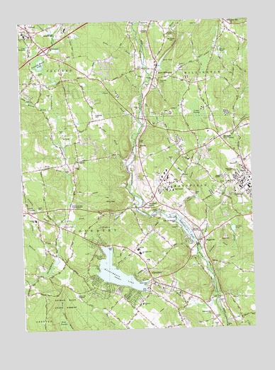
Coventry, CT USGS Topographic Map
Click on map above to begin viewing in our Map Viewer.

This topographic map contains these locations and features:
Feature Name Type Latitude Longitude GNIS ID View Map
Ball HillSummitN41.7873°W72.2642°212604View Map
Bear SwampSwampN41.7537°W72.3545°212605View Map
Bergin Correctional Institution (historical)BuildingN41.8120°W72.2978°2743040View Map
Brackett HillSummitN41.8687°W72.2912°212607View Map
Brick SchoolSchoolN41.8184°W72.3437°212608View Map
Brigham Tavern BrookStreamN41.7998°W72.3120°212609View Map
Cassidy HillSummitN41.8376°W72.3354°212610View Map
Cedar SwampSwampN41.8382°W72.2791°212611View Map
Cedar Swamp BrookStreamN41.7954°W72.2895°212612View Map
Center CemeteryCemeteryN41.7990°W72.3659°212613View Map
Cider MillpondLakeN41.8650°W72.3701°212615View Map
Clark BrookStreamN41.8351°W72.3098°212616View Map
Clough BrookStreamN41.8670°W72.3554°212617View Map
Conant BrookStreamN41.8534°W72.3034°212618View Map
CoventryPopulated PlaceN41.7701°W72.3051°212652View Map
Coventry BrookStreamN41.7943°W72.3548°212619View Map
Coventry LakePopulated PlaceN41.7723°W72.3326°1867095View Map
Coventry Lake Census Designated PlaceCensusN41.7736°W72.3287°2377811View Map
Coventry Police DepartmentBuildingN41.7771°W72.3095°2754686View Map
Coventry Volunteer Fire Association Station 208BuildingN41.7631°W72.3229°2420159View Map
Coventry Volunteer Fire Association Station 8 HeadquartersBuildingN41.7797°W72.3127°2420160View Map
Decew PondReservoirN41.7595°W72.2734°1771205View Map
Dunham PondLakeN41.7900°W72.2606°212621View Map
Dunham Pond BrookStreamN41.7782°W72.2773°212620View Map
EaglevillePopulated PlaceN41.7868°W72.2765°212622View Map
Eagleville BrookStreamN41.7857°W72.2804°212623View Map
Eagleville LakeReservoirN41.7908°W72.2869°1770506View Map
Eagleville Lake DamDamN41.7847°W72.2810°1770505View Map
Eagleville PondLakeN41.7908°W72.2869°212624View Map
George Hersey Robertson SchoolSchoolN41.7598°W72.3101°212648View Map
Green BrookStreamN41.8604°W72.3065°212626View Map
Gurley CemeteryCemeteryN41.8037°W72.2807°212627View Map
Halls PondReservoirN41.8588°W72.2968°212628View Map
Halls Pond DamDamN41.8571°W72.2993°1771437View Map
Hemlock BrookStreamN41.7732°W72.3642°212629View Map
Lee BrookStreamN41.7948°W72.3517°212630View Map
Mansfield DepotPopulated PlaceN41.8015°W72.3065°212632View Map
Mansfield Fire Department Station 107BuildingN41.7857°W72.2765°2420011View Map
Mansfield Fire Department Station 207BuildingN41.8308°W72.2715°2420015View Map
Mansfield Four CornersPopulated PlaceN41.8273°W72.2662°212631View Map
MerrowPopulated PlaceN41.8245°W72.3104°212634View Map
Metcalf BrookStreamN41.8398°W72.3587°212635View Map
Mill BrookStreamN41.7645°W72.2706°212636View Map
Nathan Hale BirthplaceLocaleN41.7643°W72.3456°212637View Map
Nathan Hale CemeteryCemeteryN41.7682°W72.3076°212638View Map
Nathan Hale State ForestForestN41.7668°W72.3476°212639View Map
Nelson BrookStreamN41.8109°W72.2845°212640View Map
Newcomb BrookStreamN41.8476°W72.3098°212641View Map
North CoventryPopulated PlaceN41.7984°W72.3717°212642View Map
North Coventry Fire Department Station 11 HeadquartersBuildingN41.7953°W72.3663°2420161View Map
North Coventry Fire Department Station 211BuildingN41.8179°W72.3434°2420162View Map
Olsons BrookStreamN41.7851°W72.3570°212603View Map
Paulk Hill BrookStreamN41.8626°W72.3679°212643View Map
Pelican PondLakeN41.8632°W72.2655°212644View Map
Pinney HillSummitN41.8518°W72.2967°212645View Map
Reed BrookStreamN41.8154°W72.3512°212646View Map
Riley MountainSummitN41.8012°W72.3290°212647View Map
Sharps MillpondLakeN41.8708°W72.2908°212650View Map
South CoventryPopulated PlaceN41.7701°W72.3051°1867101View Map
South Coventry Census Designated PlaceCensusN41.7650°W72.2974°2377862View Map
South Coventry DamDamN41.7618°W72.2729°1771204View Map
South Coventry StationLocaleN41.7632°W72.2706°212653View Map
South WillingtonPopulated PlaceN41.8554°W72.3015°212654View Map
South Willington BrookStreamN41.8504°W72.3051°212655View Map
Stony Batter PondReservoirN41.7834°W72.3729°1771201View Map
Stony Batter Pond DamDamN41.7834°W72.3729°1771200View Map
Storrs Census Designated PlaceCensusN41.8045°W72.2551°2377867View Map
Swan LakeLakeN41.8110°W72.2526°212657View Map
TollandPopulated PlaceN41.8715°W72.3687°212658View Map
Tolland CemeteryCemeteryN41.8526°W72.3637°212659View Map
Tolland CountyCivilN41.8551°W72.3365°212668View Map
Tolland Fire Department Station 240BuildingN41.8605°W72.3531°2420169View Map
Tolland Fire Marshal's OfficeBuildingN41.8697°W72.3684°2420006View Map
Tolland Marsh PondLakeN41.8593°W72.3630°212660View Map
Tolland Resident State Trooper OfficeBuildingN41.8721°W72.3679°2754738View Map
Town of CoventryCivilN41.7828°W72.3394°213413View Map
University of ConnecticutSchoolN41.8093°W72.2537°212662View Map
University of Connecticut Experiment FarmSchoolN41.7993°W72.3456°212661View Map
University of Connecticut Fire DepartmentBuildingN41.8097°W72.2604°2656254View Map
Wangumbaug LakeLakeN41.7729°W72.3242°212663View Map
WHUS-FM (Storrs)TowerN41.8134°W72.2587°213293View Map
Willington Fire Department 1 Station 213BuildingN41.8555°W72.3008°2420051View Map
Willington Fire Marshal's OfficeBuildingN41.8577°W72.2758°2420045View Map
Willington Hill Fire Department Station 49BuildingN41.8717°W72.2621°2420090View Map
Winding BrookStreamN41.8168°W72.3162°212666View Map

Note: Coordinates in the location and feature list above are referenced to NAD83 datum.


Copyright (C) 2008-2024 Ryan Niemi / Sunset Dynamics ... All Rights Reserved