TopoQuest Logo
Do you find TopoQuest useful?
Help keep TopoQuest running and adding new maps/features by donating!
Bitcoin:  19c7KJd3qBynnjoSw5npx9KScwjBe4ifkT
Litecoin:  LXs6TkuXGGXo1vDsWCkWVdjQX94eUKd6ui
Home View Maps Find Maps Find Places Resources & Links


Crawfordville, Georgia Topographic Map

USGS Map Title: Crawfordville, GA
USGS Map MRC: 33082E8
DRG (GeoTIFF) Download: o33082e8.tif


Neighboring USGS Topographic Map Quads:


  Woodville, GA  
33083F1
 

  Philomath, GA  
33082F8
 

  Washington West, GA  
33082F7
 

  Union Point, GA  
33083E1
 

  Crawfordville, GA  
33082E8
 

  Sharon, GA  
33082E7
 

  White Plains, GA  
33083D1
 

  Sparta NW, GA  
33082D8
 

  Sparta NE, GA  
33082D7


Map MRC Location:

N34°
W83°
N34°
W82°
H8 H7 H6 H5 H4 H3 H2 H1
G8 G7 G6 G5 G4 G3 G2 G1
F8 F7 F6 F5 F4 F3 F2 F1
E8 E7 E6 E5 E4 E3 E2 E1
D8 D7 D6 D5 D4 D3 D2 D1
C8 C7 C6 C5 C4 C3 C2 C1
B8 B7 B6 B5 B4 B3 B2 B1
A8 A7 A6 A5 A4 A3 A2 A1
N33°
W83°
N33°
W82°

Crawfordville, GA USGS 1:24K Topographic Map Preview:
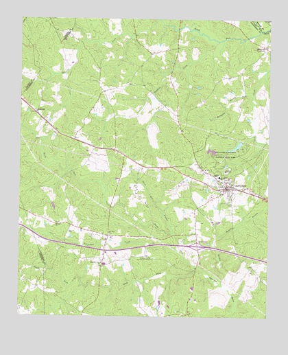
Crawfordville, GA USGS Topographic Map
Click on map above to begin viewing in our Map Viewer.

This topographic map contains these locations and features:
Feature Name Type Latitude Longitude GNIS ID View Map
Alexander H Stephens Memorial State ParkParkN33.5682°W82.8965°354279View Map
Alexander Stephens Park LakeReservoirN33.5717°W82.8911°336439View Map
Alexander Stephens Park Lake DamDamN33.5735°W82.8882°336438View Map
Alezander Stephens State Park DamDamN33.5701°W82.8982°338776View Map
Beaverdam CreekStreamN33.5299°W82.9201°310996View Map
City of CrawfordvilleCivilN33.5545°W82.8965°2404146View Map
Confederate MuseumBuildingN33.5579°W82.8960°347611View Map
CrawfordvillePopulated PlaceN33.5540°W82.8960°313097View Map
Crawfordville Baptist ChurchChurchN33.5582°W82.8949°347612View Map
Crawfordville Baptist SchoolSchoolN33.5579°W82.8949°347613View Map
Crawfordville CemeteryCemeteryN33.5576°W82.8932°347614View Map
Crawfordville City HallBuildingN33.5540°W82.8960°347615View Map
Crawfordville City Police DepartmentBuildingN33.5547°W82.8968°2733885View Map
Crawfordville DivisionCivilN33.5591°W82.9267°1936205View Map
Crawfordville Post OfficePost OfficeN33.5543°W82.8938°347616View Map
Crawfordville Presbyterian ChurchChurchN33.5549°W82.8979°347617View Map
Crawfordville United Methodist ChurchChurchN33.5532°W82.8976°347618View Map
Edgewood CrossroadsPopulated PlaceN33.6132°W82.8774°326260View Map
Ellington BranchStreamN33.5937°W82.8826°313916View Map
Friendship CemeteryCemeteryN33.5621°W82.9060°347622View Map
Friendship Church (historical)ChurchN33.5618°W82.9068°347623View Map
Friendship School (historical)SchoolN33.5618°W82.9071°347624View Map
Gunn HillSummitN33.5499°W82.9393°331889View Map
Gunn Hill BranchStreamN33.5354°W82.9224°314987View Map
Hubert BranchStreamN33.5337°W82.8999°315775View Map
Interchange 55CrossingN33.5299°W82.9104°347626View Map
Liberty HallBuildingN33.5579°W82.8957°347629View Map
Low Lot CemeteryCemeteryN33.5354°W82.9749°317455View Map
Margarets Grove CemeteryCemeteryN33.5229°W82.9585°347631View Map
Mile BranchStreamN33.5115°W82.8943°318149View Map
Mount Olive CemeteryCemeteryN33.5390°W82.9815°347633View Map
Mount Olive ChurchChurchN33.5382°W82.9818°318780View Map
Murden SchoolSchoolN33.5587°W82.8993°319152View Map
New Hope CemeteryCemeteryN33.5346°W82.9549°347635View Map
New Hope ChurchChurchN33.5351°W82.9546°319419View Map
North Fork Little RiverStreamN33.6204°W82.8796°329048View Map
North Fork Ogeechee RiverStreamN33.5204°W82.9088°347179View Map
RobinsonPopulated PlaceN33.5854°W82.9921°326493View Map
Robinson Baptist ChurchChurchN33.5829°W82.9879°347641View Map
Sherrills CreekStreamN33.6246°W82.9299°322841View Map
South Fork Little RiverStreamN33.6204°W82.8793°323245View Map
South Fork Ogeechee RiverStreamN33.5204°W82.9088°323247View Map
Stephens ChapelChurchN33.5596°W82.9026°323572View Map
Stephens CreekStreamN33.6157°W82.8996°323573View Map
Stephens InstituteSchoolN33.5612°W82.8965°323576View Map
Taliaferro CountyCivilN33.5661°W82.8788°347654View Map
Taliaferro County CourthouseBuildingN33.5546°W82.8965°347655View Map
Taliaferro County Jail (historical)BuildingN33.5546°W82.8963°347656View Map
Taliaferro County LibraryBuildingN33.5537°W82.8957°347657View Map
Taliaferro County SchoolSchoolN33.5584°W82.9095°2545548View Map
Taliaferro County Sheriff's OfficeBuildingN33.5546°W82.8966°2733692View Map
Taliaferro County Volunteer Fire Department Station 1BuildingN33.5539°W82.8958°2604650View Map
Taliaferro County Volunteer Fire Department Station 2BuildingN33.5342°W82.9499°2604651View Map

Note: Coordinates in the location and feature list above are referenced to NAD83 datum.


Copyright (C) 2008-2025 Ryan Niemi / Sunset Dynamics ... All Rights Reserved