TopoQuest Logo
Do you find TopoQuest useful?
Help keep TopoQuest running and adding new maps/features by donating!
Bitcoin:  19c7KJd3qBynnjoSw5npx9KScwjBe4ifkT
Litecoin:  LXs6TkuXGGXo1vDsWCkWVdjQX94eUKd6ui
Home View Maps Find Maps Find Places Resources & Links


Philomath, Georgia Topographic Map

USGS Map Title: Philomath, GA
USGS Map MRC: 33082F8
DRG (GeoTIFF) Download: o33082f8.tif


Neighboring USGS Topographic Map Quads:


  Lexington, GA  
33083G1
 

  Rayle, GA  
33082G8
 

  Celeste, GA  
33082G7
 

  Woodville, GA  
33083F1
 

  Philomath, GA  
33082F8
 

  Washington West, GA  
33082F7
 

  Union Point, GA  
33083E1
 

  Crawfordville, GA  
33082E8
 

  Sharon, GA  
33082E7


Map MRC Location:

N34°
W83°
N34°
W82°
H8 H7 H6 H5 H4 H3 H2 H1
G8 G7 G6 G5 G4 G3 G2 G1
F8 F7 F6 F5 F4 F3 F2 F1
E8 E7 E6 E5 E4 E3 E2 E1
D8 D7 D6 D5 D4 D3 D2 D1
C8 C7 C6 C5 C4 C3 C2 C1
B8 B7 B6 B5 B4 B3 B2 B1
A8 A7 A6 A5 A4 A3 A2 A1
N33°
W83°
N33°
W82°

Philomath, GA USGS 1:24K Topographic Map Preview:
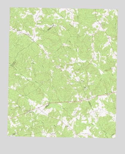
Philomath, GA USGS Topographic Map
Click on map above to begin viewing in our Map Viewer.

This topographic map contains these locations and features:
Feature Name Type Latitude Longitude GNIS ID View Map
Andrew BranchStreamN33.6785°W82.9693°310535View Map
Armours FordCrossingN33.6937°W82.9957°335722View Map
Beasley CemeteryCemeteryN33.6648°W82.9838°1705387View Map
Carlton BranchStreamN33.6890°W82.8885°312338View Map
Carters GrovePopulated PlaceN33.6935°W82.9432°355012View Map
Carters Grove Baptist ChurchChurchN33.6937°W82.9271°347608View Map
Carters Grove CemeteryCemeteryN33.6937°W82.9279°347609View Map
County Line CemeteryCemeteryN33.7357°W82.9676°342829View Map
County Line ChurchChurchN33.7357°W82.9674°355344View Map
Court GroundLocaleN33.7346°W82.8940°355349View Map
DanielPopulated PlaceN33.6640°W82.9026°342750View Map
Daniel SpringsPopulated PlaceN33.6496°W82.9749°355442View Map
Daniel SpringsSpringN33.6487°W82.9751°313287View Map
Hatchet BranchStreamN33.7276°W82.9199°315230View Map
Hobb BranchStreamN33.7057°W82.9185°315472View Map
Johnson PondReservoirN33.6735°W82.9098°316182View Map
Kettle Creek BattlefieldLocaleN33.6862°W82.8860°342768View Map
King BranchStreamN33.6773°W82.9051°316426View Map
Live Oak ChurchChurchN33.6965°W82.9701°317256View Map
Lunceford BranchStreamN33.7096°W82.9224°317489View Map
LynevillePopulated PlaceN33.6360°W82.9296°326382View Map
Lynn CreekStreamN33.6385°W82.9596°350757View Map
Moore BranchStreamN33.7001°W82.9074°318427View Map
New Salem ChurchChurchN33.6690°W82.8790°319538View Map
New Spring Hill ChurchChurchN33.7237°W82.9765°319547View Map
Phillips Mill CemeteryCemeteryN33.6690°W82.8844°342783View Map
Phillips Mill ChurchChurchN33.6685°W82.8832°320467View Map
PhilomathPopulated PlaceN33.7273°W82.9913°332654View Map
Philomath Academy (historical)SchoolN33.7273°W82.9918°335786View Map
Philomath CemeteryCemeteryN33.7285°W82.9921°342830View Map
Philomath Historic DistrictParkN33.7262°W82.9874°335787View Map
Philomath Post OfficePost OfficeN33.7262°W82.9871°352100View Map
Philomath Presbyterian ChurchChurchN33.7276°W82.9924°335788View Map
Philomath Volunteer Fire DepartmentBuildingN33.7290°W82.9971°2604057View Map
Spring Hill ChurchChurchN33.7140°W82.9924°323436View Map
SpringfieldPopulated PlaceN33.6279°W82.9490°326528View Map
Springfield Baptist ChurchChurchN33.6265°W82.9494°2761156View Map
Syls ForkStreamN33.6943°W82.9971°356575View Map
Thaxton CemeteryCemeteryN33.7404°W82.9676°324031View Map
Tuggle BranchStreamN33.6537°W82.9876°324354View Map
Victory ChurchChurchN33.7360°W82.8943°324698View Map
War HillSummitN33.6921°W82.8829°333361View Map
War Hill MonumentParkN33.6907°W82.8860°342808View Map
White CreekStreamN33.6535°W82.9368°325152View Map

Note: Coordinates in the location and feature list above are referenced to NAD83 datum.


Copyright (C) 2008-2025 Ryan Niemi / Sunset Dynamics ... All Rights Reserved