TopoQuest Logo
Do you find TopoQuest useful?
Help keep TopoQuest running and adding new maps/features by donating!
Bitcoin:  19c7KJd3qBynnjoSw5npx9KScwjBe4ifkT
Litecoin:  LXs6TkuXGGXo1vDsWCkWVdjQX94eUKd6ui
Home View Maps Find Maps Find Places Resources & Links


Woodville, Georgia Topographic Map

USGS Map Title: Woodville, GA
USGS Map MRC: 33083F1
DRG (GeoTIFF) Download: o33083f1.tif


Neighboring USGS Topographic Map Quads:


  Maxeys, GA  
33083G2
 

  Lexington, GA  
33083G1
 

  Rayle, GA  
33082G8
 

  Penfield, GA  
33083F2
 

  Woodville, GA  
33083F1
 

  Philomath, GA  
33082F8
 

  Greensboro, GA  
33083E2
 

  Union Point, GA  
33083E1
 

  Crawfordville, GA  
33082E8


Map MRC Location:

N34°
W84°
N34°
W83°
H8 H7 H6 H5 H4 H3 H2 H1
G8 G7 G6 G5 G4 G3 G2 G1
F8 F7 F6 F5 F4 F3 F2 F1
E8 E7 E6 E5 E4 E3 E2 E1
D8 D7 D6 D5 D4 D3 D2 D1
C8 C7 C6 C5 C4 C3 C2 C1
B8 B7 B6 B5 B4 B3 B2 B1
A8 A7 A6 A5 A4 A3 A2 A1
N33°
W84°
N33°
W83°

Woodville, GA USGS 1:24K Topographic Map Preview:
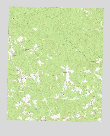
Woodville, GA USGS Topographic Map
Click on map above to begin viewing in our Map Viewer.

This topographic map contains these locations and features:
Feature Name Type Latitude Longitude GNIS ID View Map
Absalom Janes CemeteryCemeteryN33.6757°W83.0051°1705385View Map
Armstrong CemeteryCemeteryN33.6979°W83.0843°1705386View Map
Asbury Church (historical)ChurchN33.6346°W83.0102°348646View Map
Bairds ChurchChurchN33.6993°W83.1149°354433View Map
BairdstownPopulated PlaceN33.6982°W83.1188°354434View Map
Bairdstown CemeteryCemeteryN33.7010°W83.1160°335726View Map
BethesdaPopulated PlaceN33.6343°W83.0096°331147View Map
Bethesda CemeteryCemeteryN33.6518°W83.0093°348648View Map
Bethesda ChurchChurchN33.6523°W83.0099°354653View Map
Bowles-Durham CemeteryCemeteryN33.6771°W83.0479°1705390View Map
Broach CemeteryCemeteryN33.6535°W83.0915°1705392View Map
Buena Vista School (historical)SchoolN33.6340°W83.0099°348652View Map
Calloway CreekStreamN33.7162°W83.0607°354939View Map
City of WoodvilleCivilN33.6714°W83.1063°2405789View Map
Crossroads School (historical)SchoolN33.6354°W83.0304°348660View Map
Durham TownPopulated PlaceN33.6618°W83.0324°331607View Map
Fluker BranchStreamN33.6571°W83.0177°314247View Map
Fluker CemeteryCemeteryN33.6712°W83.0226°1705401View Map
Grantville (historical)Populated PlaceN33.6354°W83.0299°348671View Map
Greene CemeteryCemeteryN33.6757°W83.0599°1705406View Map
Griffin CreekStreamN33.7062°W83.0377°314906View Map
Hurricane CreekStreamN33.7229°W83.0790°315848View Map
JacksonvillePopulated PlaceN33.6326°W83.0379°332081View Map
L H Cook CemeteryCemeteryN33.6687°W83.0863°1705416View Map
Mitchell CemeteryCemeteryN33.6393°W83.0326°1705421View Map
Raiden CreekStreamN33.7226°W83.0790°329356View Map
Randolph ChurchChurchN33.6812°W83.0135°321309View Map
Reservoir 26ReservoirN33.6477°W83.0482°336432View Map
Reservoir 31ReservoirN33.6567°W83.0599°336433View Map
Reynolds CemeteryCemeteryN33.6851°W83.0910°1705430View Map
Saint Pauls ChurchChurchN33.6807°W83.1110°322282View Map
Stewarts LakeReservoirN33.6395°W83.0848°323608View Map
Stewarts Lake DamDamN33.6401°W83.0827°339038View Map
Temperance BellPopulated PlaceN33.6762°W83.0479°326544View Map
Temple Bell School (historical)SchoolN33.6771°W83.0477°348724View Map
Thornton CreekStreamN33.6479°W83.0468°324135View Map
Tuggle CemeteryCemeteryN33.6457°W83.0140°348728View Map
Tuggle CemeteryCemeteryN33.6685°W83.0574°1705437View Map
Tuggle CreekStreamN33.6493°W83.0349°324355View Map
Union Point DivisionCivilN33.6358°W83.0337°1936609View Map
Watts BridgeBridgeN33.7140°W83.0482°335804View Map
WoodvillePopulated PlaceN33.6715°W83.1060°356651View Map
Woodville Baptist ChurchChurchN33.6715°W83.1007°348739View Map
Woodville CemeteryCemeteryN33.6701°W83.0988°1705446View Map
Woodville Volunteer Fire DepartmentBuildingN33.6726°W83.1007°2604223View Map

Note: Coordinates in the location and feature list above are referenced to NAD83 datum.


Copyright (C) 2008-2025 Ryan Niemi / Sunset Dynamics ... All Rights Reserved