TopoQuest Logo
Do you find TopoQuest useful?
Help keep TopoQuest running and adding new maps/features by donating!
Bitcoin:  19c7KJd3qBynnjoSw5npx9KScwjBe4ifkT
Litecoin:  LXs6TkuXGGXo1vDsWCkWVdjQX94eUKd6ui
Home View Maps Find Maps Find Places Resources & Links


Crowville, Louisiana Topographic Map

USGS Map Title: Crowville, LA
USGS Map MRC: 32091B5
DRG (GeoTIFF) Download: o32091b5.tif


Neighboring USGS Topographic Map Quads:


  Baskinton, LA  
32091C6
 

  Lamar, LA  
32091C5
 

  Indian Lake, LA  
32091C4
 

  Winnsboro, LA  
32091B6
 

  Crowville, LA  
32091B5
 

  Tensas Bluff, LA  
32091B4
 

  Gilbert, LA  
32091A6
 

  Como, LA  
32091A5
 

  Newlight, LA  
32091A4


Map MRC Location:

N33°
W92°
N33°
W91°
H8 H7 H6 H5 H4 H3 H2 H1
G8 G7 G6 G5 G4 G3 G2 G1
F8 F7 F6 F5 F4 F3 F2 F1
E8 E7 E6 E5 E4 E3 E2 E1
D8 D7 D6 D5 D4 D3 D2 D1
C8 C7 C6 C5 C4 C3 C2 C1
B8 B7 B6 B5 B4 B3 B2 B1
A8 A7 A6 A5 A4 A3 A2 A1
N32°
W92°
N32°
W91°

Crowville, LA USGS 1:24K Topographic Map Preview:
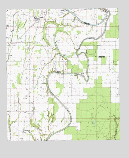
Crowville, LA USGS Topographic Map
Click on map above to begin viewing in our Map Viewer.

This topographic map contains these locations and features:
Feature Name Type Latitude Longitude GNIS ID View Map
Augusta Baptist ChurchChurchN32.1527°W91.6040°553326View Map
Bayou Macon Cutoff Number 2ChannelN32.2496°W91.5182°541663View Map
Boggy BayouGutN32.1477°W91.5796°533276View Map
Boggy Womble BrakeSwampN32.1535°W91.5715°533301View Map
Brannin Ferry (historical)CrossingN32.1285°W91.5793°1631160View Map
BushesPopulated PlaceN32.2174°W91.6162°543048View Map
Chelly LandingPopulated PlaceN32.1643°W91.5679°543078View Map
Collier Flying Service Landing StripAirportN32.2471°W91.5840°544078View Map
Crocketts Point Baptist ChurchChurchN32.2482°W91.5601°554130View Map
CrowvillePopulated PlaceN32.2407°W91.5901°543119View Map
Crowville CemeteryCemeteryN32.2401°W91.5876°544079View Map
Crowville Methodist ChurchChurchN32.2396°W91.5896°544570View Map
Crowville SchoolSchoolN32.2413°W91.5925°544080View Map
Crowville Volunteer Fire DepartmentBuildingN32.2411°W91.5899°2672933View Map
Deep BayouStreamN32.2340°W91.5296°534447View Map
Egypt Ferry (historical)CrossingN32.1677°W91.5726°1631167View Map
Egypt Ferry Gas FieldOilfieldN32.1807°W91.5682°544081View Map
First Baptist Church of CrowvilleChurchN32.2401°W91.5885°544573View Map
Fish Bayou ChurchChurchN32.1868°W91.5496°534961View Map
French TurnBendN32.2418°W91.5126°541674View Map
French Turn ChurchChurchN32.2324°W91.5190°535104View Map
Harris CemeteryCemeteryN32.2026°W91.5621°541672View Map
Harris LakeLakeN32.2056°W91.5618°554668View Map
Hog LakeLakeN32.1414°W91.5287°554726View Map
Hollywood LakeLakeN32.2175°W91.5708°535739View Map
Howell BrakeSwampN32.1824°W91.6118°541671View Map
Hurricane BayouStreamN32.2479°W91.5582°554808View Map
Jesus Name Christian SchoolSchoolN32.2010°W91.5743°544580View Map
Jesus Name ChurchChurchN32.2010°W91.5743°556636View Map
Kollen LandingLocaleN32.1896°W91.5707°1631172View Map
Liberty ChurchChurchN32.2215°W91.5193°536421View Map
Lone Pine Baptist ChurchChurchN32.1952°W91.5704°555131View Map
Magnolia CemeteryCemeteryN32.1657°W91.6051°544094View Map
Magnolia ChurchChurchN32.1654°W91.6051°554350View Map
Masonic CemeteryCemeteryN32.2488°W91.5796°556635View Map
Mill BayouGutN32.2193°W91.5515°541673View Map
New Hope ChurchChurchN32.2176°W91.5110°537581View Map
New Lillie ChurchChurchN32.2088°W91.6226°537608View Map
Providence Memorial Park CemeteryCemeteryN32.1349°W91.6082°541670View Map
Redfield LakeLakeN32.1435°W91.5596°555777View Map
Saint Luke ChurchChurchN32.1854°W91.6037°538946View Map
Sallers BayouGutN32.1704°W91.6015°539106View Map
SwampersPopulated PlaceN32.1910°W91.5710°556179View Map
Turkey Bluff ChurchChurchN32.1863°W91.5435°559741View Map
Ward 3 High School (historical)SchoolN32.1744°W91.6032°1629803View Map
Ward ThreeCivilN32.1454°W91.5785°545028View Map

Note: Coordinates in the location and feature list above are referenced to NAD83 datum.


Copyright (C) 2008-2024 Ryan Niemi / Sunset Dynamics ... All Rights Reserved