TopoQuest Logo
Do you find TopoQuest useful?
Help keep TopoQuest running and adding new maps/features by donating!
Bitcoin:  19c7KJd3qBynnjoSw5npx9KScwjBe4ifkT
Litecoin:  LXs6TkuXGGXo1vDsWCkWVdjQX94eUKd6ui
Home View Maps Find Maps Find Places Resources & Links


Como, Louisiana Topographic Map

USGS Map Title: Como, LA
USGS Map MRC: 32091A5
DRG (GeoTIFF) Download: o32091a5.tif


Neighboring USGS Topographic Map Quads:


  Winnsboro, LA  
32091B6
 

  Crowville, LA  
32091B5
 

  Tensas Bluff, LA  
32091B4
 

  Gilbert, LA  
32091A6
 

  Como, LA  
32091A5
 

  Newlight, LA  
32091A4
 

  Wisner, LA  
31091H6
 

  Oakley, LA  
31091H5
 

  Gretna Green, LA  
31091H4


Map MRC Location:

N33°
W92°
N33°
W91°
H8 H7 H6 H5 H4 H3 H2 H1
G8 G7 G6 G5 G4 G3 G2 G1
F8 F7 F6 F5 F4 F3 F2 F1
E8 E7 E6 E5 E4 E3 E2 E1
D8 D7 D6 D5 D4 D3 D2 D1
C8 C7 C6 C5 C4 C3 C2 C1
B8 B7 B6 B5 B4 B3 B2 B1
A8 A7 A6 A5 A4 A3 A2 A1
N32°
W92°
N32°
W91°

Como, LA USGS 1:24K Topographic Map Preview:
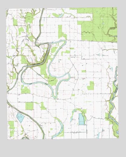
Como, LA USGS Topographic Map
Click on map above to begin viewing in our Map Viewer.

This topographic map contains these locations and features:
Feature Name Type Latitude Longitude GNIS ID View Map
Bayou Macon Baptist ChurchChurchN32.0943°W91.6004°553487View Map
Bayou Macon Cutoff Number OneCanalN32.0863°W91.6085°553320View Map
Beeler LakeLakeN32.1177°W91.5632°553577View Map
Bethel Christian CenterChurchN32.0793°W91.6173°541680View Map
Bethel SchoolSchoolN32.0793°W91.6171°544074View Map
Big Cow LakeLakeN32.0024°W91.5230°553635View Map
Board Tree LakeLakeN32.0181°W91.5423°533247View Map
Calf LakeLakeN32.0078°W91.5184°553859View Map
Church of God (historical)ChurchN32.1038°W91.6023°544076View Map
ComoPopulated PlaceN32.0988°W91.6026°543099View Map
Cordill School (historical)SchoolN32.1238°W91.6076°1631163View Map
Cuba Baptist ChurchChurchN32.1085°W91.6021°554150View Map
Cuba SchoolSchoolN32.1074°W91.6029°534301View Map
Dickey LandingPopulated PlaceN32.0890°W91.5904°543145View Map
Dixie LandingPopulated PlaceN32.0535°W91.5807°543147View Map
East Johnson LakeLakeN32.0794°W91.5174°554324View Map
Eureka Baptist ChurchChurchN32.0124°W91.5885°554370View Map
Eureka CemeteryCemeteryN32.0135°W91.5890°544082View Map
GriffinPopulated PlaceN32.0377°W91.5671°543264View Map
Harris LandingPopulated PlaceN32.1107°W91.5873°543281View Map
Johnson LakeLakeN32.0800°W91.5209°554891View Map
Lake DeanLakeN32.0067°W91.5658°554204View Map
Little Cow LakeLakeN32.0186°W91.5532°555064View Map
Long BayouGutN32.0899°W91.5173°536677View Map
LoreleinPopulated PlaceN32.0940°W91.5529°543416View Map
Middle LakeLakeN32.0270°W91.5498°555308View Map
Moon LakeLakeN32.0666°W91.5067°555360View Map
Muddy BayouStreamN32.0704°W91.6021°537477View Map
Oakley LandingPopulated PlaceN32.0313°W91.6198°543548View Map
Oakwood LandingPopulated PlaceN32.0607°W91.5748°543551View Map
Parish Governing Authority District 3CivilN32.0572°W91.5809°1929952View Map
Sandy BayouStreamN32.0852°W91.5135°556517View Map
Snyder BrakeSwampN32.1160°W91.5990°541678View Map
State Place CemeteryCemeteryN32.1021°W91.6032°541679View Map
Stillhouse CreekStreamN32.0949°W91.5912°539670View Map
Stones LandingPopulated PlaceN32.0849°W91.5671°543703View Map
Talbot LandingPopulated PlaceN32.0890°W91.5607°543712View Map
Ward CemeteryCemeteryN32.0796°W91.5832°541681View Map
Wards BayouStreamN32.0585°W91.5532°540231View Map
Wileys BrakeSwampN32.0221°W91.5393°540411View Map

Note: Coordinates in the location and feature list above are referenced to NAD83 datum.


Copyright (C) 2008-2025 Ryan Niemi / Sunset Dynamics ... All Rights Reserved