TopoQuest Logo
Do you find TopoQuest useful?
Help keep TopoQuest running and adding new maps/features by donating!
Bitcoin:  19c7KJd3qBynnjoSw5npx9KScwjBe4ifkT
Litecoin:  LXs6TkuXGGXo1vDsWCkWVdjQX94eUKd6ui
Home View Maps Find Maps Find Places Resources & Links


Emlenton, Pennsylvania Topographic Map

USGS Map Title: Emlenton, PA
USGS Map MRC: 41079B6
DRG (GeoTIFF) Download: o41079b6.tif


Neighboring USGS Topographic Map Quads:


  Kennerdell, PA  
41079C7
 

  Cranberry, PA  
41079C6
 

  Kossuth, PA  
41079C5
 

  Eau Claire, PA  
41079B7
 

  Emlenton, PA  
41079B6
 

  Knox, PA  
41079B5
 

  Hilliards, PA  
41079A7
 

  Parker, PA  
41079A6
 

  Rimersburg, PA  
41079A5


Map MRC Location:

N42°
W80°
N42°
W79°
H8 H7 H6 H5 H4 H3 H2 H1
G8 G7 G6 G5 G4 G3 G2 G1
F8 F7 F6 F5 F4 F3 F2 F1
E8 E7 E6 E5 E4 E3 E2 E1
D8 D7 D6 D5 D4 D3 D2 D1
C8 C7 C6 C5 C4 C3 C2 C1
B8 B7 B6 B5 B4 B3 B2 B1
A8 A7 A6 A5 A4 A3 A2 A1
N41°
W80°
N41°
W79°

Emlenton, PA USGS 1:24K Topographic Map Preview:
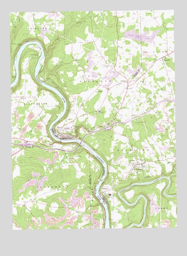
Emlenton, PA USGS Topographic Map
Click on map above to begin viewing in our Map Viewer.

This topographic map contains these locations and features:
Feature Name Type Latitude Longitude GNIS ID View Map
Allegheny Clarion Valley High SchoolSchoolN41.1445°W79.6756°1211506View Map
Allegheny Valley CampLocaleN41.2256°W79.7281°1168175View Map
Alum RockSummitN41.1562°W79.6323°1201394View Map
Barricks RunStreamN41.2401°W79.7448°1200579View Map
Big Bend ChurchChurchN41.2009°W79.7417°1169479View Map
Borough of EmlentonCivilN41.1805°W79.7073°1217323View Map
Borough of FoxburgCivilN41.1459°W79.6802°1215084View Map
Borough of Saint PetersburgCivilN41.1610°W79.6545°1215089View Map
Distlers CornersLocaleN41.2176°W79.6706°1212813View Map
DotterPopulated PlaceN41.2117°W79.7228°1203436View Map
EmlentonPopulated PlaceN41.1773°W79.7078°1174224View Map
Emlenton Area Ambulance ServiceBuildingN41.1779°W79.7081°2719461View Map
Emlenton Borough Police DepartmentBuildingN41.1777°W79.7093°2781071View Map
Emlenton Elementary SchoolSchoolN41.1778°W79.7092°1211508View Map
Emlenton Fire Department Station 55BuildingN41.1774°W79.7077°2644778View Map
Emlenton Municipal Airport (historical)AirportN41.2026°W79.6795°1194191View Map
Emlenton Post OfficePost OfficeN41.1774°W79.7121°2779616View Map
Fowler RunStreamN41.1403°W79.6825°1175086View Map
FoxburgPopulated PlaceN41.1431°W79.6798°1175114View Map
Foxburg Golf CourseLocaleN41.1490°W79.6773°1205605View Map
Foxburg Post OfficePost OfficeN41.1409°W79.6794°2779622View Map
Foxburg Volunteer Fire Department Station 550BuildingN41.1412°W79.6799°2645658View Map
HoodvilleLocaleN41.2017°W79.7406°1212811View Map
Hunts Cove AirportAirportN41.1459°W79.6873°1194181View Map
Kahle LakeReservoirN41.2352°W79.6499°1195381View Map
Kahle Lake DamDamN41.2359°W79.6626°1195382View Map
Kahle TowerTowerN41.1859°W79.6495°1212464View Map
Keefer MillLocaleN41.2467°W79.6898°1205206View Map
LamartinePopulated PlaceN41.2226°W79.6339°1178817View Map
Lamartine Post OfficePost OfficeN41.2220°W79.6354°2779867View Map
Lowrey RunStreamN41.1723°W79.6939°1192857View Map
MariasvillePopulated PlaceN41.2090°W79.6606°1180408View Map
Memorial Episcopal Church of Our Father CemeteryCemeteryN41.1453°W79.6806°2780902View Map
Mill CreekStreamN41.2248°W79.7234°1181144View Map
Old Zion ChurchChurchN41.2184°W79.6750°1182958View Map
Richey RunStreamN41.1762°W79.7000°1185006View Map
Richland ChurchChurchN41.2087°W79.6484°1185012View Map
Saint PetersburgPopulated PlaceN41.1617°W79.6528°1214006View Map
Saint Petersburg Elementary SchoolSchoolN41.1612°W79.6509°1211507View Map
Saint Petersburg Post OfficePost OfficeN41.1619°W79.6527°2780001View Map
Saint Petersburg Volunteer Fire Company Station 650BuildingN41.1616°W79.6527°2645642View Map
Sandy PointLocaleN41.1692°W79.7464°1212539View Map
Squaw ValleyValleyN41.1715°W79.6950°1188367View Map
Township of AlleghenyCivilN41.1372°W79.7388°1216041View Map
Township of HoveyCivilN41.1336°W79.6856°1215846View Map
Township of RichlandCivilN41.2409°W79.6717°1217153View Map
Township of RichlandCivilN41.1663°W79.6457°1216218View Map
Turkey RunStreamN41.1534°W79.6306°1189949View Map
West Home ChurchChurchN41.2220°W79.7012°1191045View Map
Whitehall CampLocaleN41.1926°W79.6825°1191322View Map
Wood HillPopulated PlaceN41.2128°W79.7464°1198313View Map

Note: Coordinates in the location and feature list above are referenced to NAD83 datum.


Copyright (C) 2008-2024 Ryan Niemi / Sunset Dynamics ... All Rights Reserved