TopoQuest Logo
Do you find TopoQuest useful?
Help keep TopoQuest running and adding new maps/features by donating!
Bitcoin:  19c7KJd3qBynnjoSw5npx9KScwjBe4ifkT
Litecoin:  LXs6TkuXGGXo1vDsWCkWVdjQX94eUKd6ui
Home View Maps Find Maps Find Places Resources & Links


Bagnell, Missouri Topographic Map

USGS Map Title: Bagnell, MO
USGS Map MRC: 38092B5
DRG (GeoTIFF) Download: o38092b5.tif


Neighboring USGS Topographic Map Quads:


  Rocky Mount, MO  
38092C6
 

  Eldon, MO  
38092C5
 

  Eugene, MO  
38092C4
 

  Lake Ozark, MO  
38092B6
 

  Bagnell, MO  
38092B5
 

  Tuscumbia, MO  
38092B4
 

  Camdenton, MO  
38092A6
 

  Toronto, MO  
38092A5
 

  Brumley, MO  
38092A4


Map MRC Location:

N39°
W93°
N39°
W92°
H8 H7 H6 H5 H4 H3 H2 H1
G8 G7 G6 G5 G4 G3 G2 G1
F8 F7 F6 F5 F4 F3 F2 F1
E8 E7 E6 E5 E4 E3 E2 E1
D8 D7 D6 D5 D4 D3 D2 D1
C8 C7 C6 C5 C4 C3 C2 C1
B8 B7 B6 B5 B4 B3 B2 B1
A8 A7 A6 A5 A4 A3 A2 A1
N38°
W93°
N38°
W92°

Bagnell, MO USGS 1:24K Topographic Map Preview:
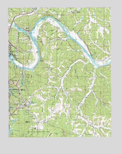
Bagnell, MO USGS Topographic Map
Click on map above to begin viewing in our Map Viewer.

This topographic map contains these locations and features:
Feature Name Type Latitude Longitude GNIS ID View Map
Arnold CemeteryCemeteryN38.1472°W92.6232°742737View Map
Arnold HollowValleyN38.2185°W92.5600°713396View Map
BagnellPopulated PlaceN38.2267°W92.6016°713534View Map
Bagnell Seaplane BaseAirportN38.2000°W92.6169°758773View Map
Barnett Church (historical)ChurchN38.1542°W92.5418°744536View Map
Barnett School (historical)SchoolN38.1445°W92.5377°744537View Map
Bear CreekStreamN38.1925°W92.5160°713797View Map
Bear HollowValleyN38.2361°W92.5752°713819View Map
Bell IslandIslandN38.2397°W92.5849°713915View Map
BlackmerLocaleN38.1575°W92.5382°742733View Map
Bowlin HollowValleyN38.1884°W92.5966°714583View Map
Brandt CemeteryCemeteryN38.2175°W92.5868°742729View Map
Brockman SpringSpringN38.2039°W92.5248°738312View Map
Brockmans IslandIslandN38.2186°W92.5928°714733View Map
Bronot CemeteryCemeteryN38.2172°W92.5882°714739View Map
Camp Red BudLocaleN38.1273°W92.6232°742738View Map
Carls Shopping CenterLocaleN38.1567°W92.6060°736113View Map
Church of GodChurchN38.1589°W92.5996°742736View Map
City of LakesideCivilN38.2041°W92.6224°2395613View Map
Colvin CemeteryCemeteryN38.1509°W92.5696°742734View Map
Colvin CemeteryCemeteryN38.1870°W92.5243°716144View Map
Colvin HollowValleyN38.1817°W92.5221°716145View Map
Cotton IslandIslandN38.2284°W92.5571°716348View Map
Darby HollowValleyN38.2423°W92.5799°716664View Map
Dry BranchStreamN38.2428°W92.6074°717076View Map
East Fork Little Bear CreekStreamN38.1773°W92.5596°717290View Map
East Fork Little Gravois CreekStreamN38.2331°W92.6210°717293View Map
Elm SpringSpringN38.1928°W92.5515°717535View Map
Elm Spring School (historical)SchoolN38.1895°W92.5546°744533View Map
Fitzgerald CemeteryCemeteryN38.2275°W92.5752°717966View Map
Flatwoods ChurchChurchN38.2453°W92.5446°742730View Map
Fletcher School (historical)SchoolN38.1528°W92.5763°744535View Map
Grandglaize Fish HatcheryLocaleN38.1417°W92.6169°755191View Map
Happy HollowValleyN38.2214°W92.5546°719067View Map
Hardy HollowValleyN38.2275°W92.5488°719090View Map
Harmony ChurchChurchN38.2453°W92.5463°729508View Map
Henderson CemeteryCemeteryN38.1736°W92.5685°742735View Map
Hudson HollowValleyN38.1895°W92.6057°719954View Map
John Allen HollowValleyN38.2420°W92.6155°720335View Map
KaiserPopulated PlaceN38.1336°W92.5899°729526View Map
Kaiser Post OfficePost OfficeN38.1394°W92.5871°2782758View Map
Lake Ozark Fire Protection District Fire BoatBuildingN38.2064°W92.6229°2620623View Map
Lake Ozark Fire Protection District Station 4BuildingN38.2445°W92.5970°2621114View Map
Lake Ozark Police DepartmentBuildingN38.1799°W92.6228°2752191View Map
LakesidePopulated PlaceN38.2078°W92.6196°738309View Map
Lakeside Airport (historical)AirportN38.1936°W92.5966°744534View Map
LakeviewPopulated PlaceN38.2145°W92.6230°738310View Map
Lawson School (historical)SchoolN38.2170°W92.5124°744532View Map
Links Landing Heliport (historical)AirportN38.1336°W92.5571°758839View Map
Little Bear CreekStreamN38.1970°W92.5230°721150View Map
Little Gravois CreekStreamN38.2225°W92.5994°721241View Map
New Harmony ChurchChurchN38.2459°W92.5410°742731View Map
Osage BeachPopulated PlaceN38.1503°W92.6180°729792View Map
Osage Beach Fire Protection District Station 1 HeadquartersBuildingN38.1610°W92.6163°2621133View Map
Osage Beach Fire Protection District Station 4BuildingN38.1386°W92.5883°2621614View Map
Osage DamDamN38.2045°W92.6230°763578View Map
Osage PlazaLocaleN38.1673°W92.6119°742012View Map
Pickering HollowValleyN38.1953°W92.5460°724306View Map
Pleasant Green Church (historical)ChurchN38.2028°W92.5944°744627View Map
Pogue HollowValleyN38.1656°W92.6185°724689View Map
Post Oak School (historical)SchoolN38.2239°W92.5707°744531View Map
Riley BluffCliffN38.2386°W92.5669°725307View Map
Riverview ChurchChurchN38.1561°W92.6049°725357View Map
Sander CemeteryCemeteryN38.2214°W92.5999°742728View Map
Sawmill HollowValleyN38.1995°W92.5207°726077View Map
Sawmill HollowValleyN38.2292°W92.5646°726078View Map
Scott CemeteryCemeteryN38.2009°W92.5057°742732View Map
Stillhouse HollowValleyN38.1989°W92.5280°727111View Map
Tent HollowValleyN38.1975°W92.5463°727534View Map
Three Springs HollowValleyN38.2095°W92.5966°727631View Map
Town of BagnellCivilN38.2294°W92.6054°2396583View Map
Township of GlazeCivilN38.1316°W92.5235°767018View Map
Wilcox BendBendN38.2392°W92.5782°728821View Map
Wildcat HollowValleyN38.1689°W92.5238°728842View Map
Wolf CreekStreamN38.1920°W92.5163°729048View Map
Wrights CreekStreamN38.2467°W92.5938°729168View Map

Note: Coordinates in the location and feature list above are referenced to NAD83 datum.


Copyright (C) 2008-2024 Ryan Niemi / Sunset Dynamics ... All Rights Reserved