TopoQuest Logo
Do you find TopoQuest useful?
Help keep TopoQuest running and adding new maps/features by donating!
Bitcoin:  19c7KJd3qBynnjoSw5npx9KScwjBe4ifkT
Litecoin:  LXs6TkuXGGXo1vDsWCkWVdjQX94eUKd6ui
Home View Maps Find Maps Find Places Resources & Links


Everett West, Pennsylvania Topographic Map

USGS Map Title: Everett West, PA
USGS Map MRC: 40078A4
DRG (GeoTIFF) Download: o40078a4.tif


Neighboring USGS Topographic Map Quads:


  Alum Bank, PA  
40078B5
 

  New Enterprise, PA  
40078B4
 

  Hopewell, PA  
40078B3
 

  Bedford, PA  
40078A5
 

  Everett West, PA  
40078A4
 

  Everett East, PA  
40078A3
 

  Rainsburg, PA  
39078H5
 

  Clearville, PA  
39078H4
 

  Mench, PA  
39078H3


Map MRC Location:

N41°
W79°
N41°
W78°
H8 H7 H6 H5 H4 H3 H2 H1
G8 G7 G6 G5 G4 G3 G2 G1
F8 F7 F6 F5 F4 F3 F2 F1
E8 E7 E6 E5 E4 E3 E2 E1
D8 D7 D6 D5 D4 D3 D2 D1
C8 C7 C6 C5 C4 C3 C2 C1
B8 B7 B6 B5 B4 B3 B2 B1
A8 A7 A6 A5 A4 A3 A2 A1
N40°
W79°
N40°
W78°

Everett West, PA USGS 1:24K Topographic Map Preview:
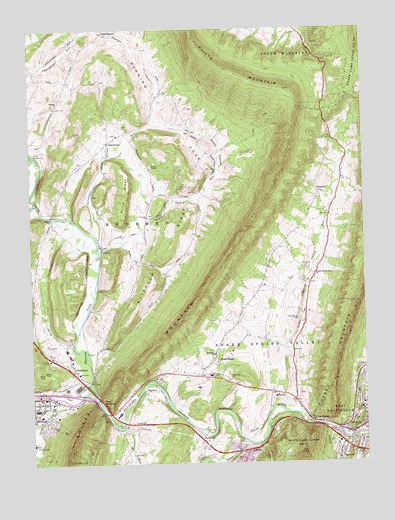
Everett West, PA USGS Topographic Map
Click on map above to begin viewing in our Map Viewer.

This topographic map contains these locations and features:
Feature Name Type Latitude Longitude GNIS ID View Map
Albright CemeteryCemeteryN40.0970°W78.4640°2776034View Map
AshcomPopulated PlaceN40.0037°W78.4192°1202991View Map
Ashcom QuarryMineN40.0081°W78.3856°2724979View Map
Bald Hill CemeteryCemeteryN40.0243°W78.4260°2776038View Map
Bald Hill ChurchChurchN40.0248°W78.4253°1168639View Map
Bedford CountyCivilN40.0066°W78.4903°1209171View Map
Bedford Middle SchoolSchoolN40.0140°W78.4964°1207342View Map
Bedford Senior High SchoolSchoolN40.0162°W78.4984°1205650View Map
Black ValleyValleyN40.0064°W78.3824°1169743View Map
Black Valley CreekStreamN40.0065°W78.3820°1192154View Map
Bubbling SpringSpringN40.0251°W78.4411°1202472View Map
Camp SunshineLocaleN40.0887°W78.4975°1171098View Map
Chaltbeate SpringSpringN40.0267°W78.4822°1201336View Map
ChalybeatePopulated PlaceN40.0281°W78.4847°1171533View Map
Cliffs (historical)Populated PlaceN40.0192°W78.4784°1201888View Map
Cove CreekStreamN40.0056°W78.4170°1172523View Map
Dunning CoveBasinN40.0979°W78.4533°1173624View Map
Dunning CreekStreamN40.0192°W78.4759°1192384View Map
Dunning CreekStreamN40.0195°W78.4759°1209118View Map
Dutch CornerPopulated PlaceN40.0898°W78.4278°1203462View Map
Elks Country ClubLocaleN40.0056°W78.4995°1213196View Map
Everett Volunteer Fire Company 32BuildingN40.0112°W78.3751°2645727View Map
ForemanPopulated PlaceN40.0779°W78.3914°1174963View Map
Friends CoveValleyN40.0056°W78.4181°1192494View Map
HartleyPopulated PlaceN40.0215°W78.4525°1176606View Map
Hershberger CemeteryCemeteryN40.0415°W78.3992°1176894View Map
HughesLocaleN40.0723°W78.4945°1207180View Map
Ice Dale Lake DamDamN40.0667°W78.3947°1194521View Map
ImlertownPopulated PlaceN40.0923°W78.4695°1177692View Map
Imlertown RunStreamN40.0648°W78.4750°1192657View Map
LutzvillePopulated PlaceN40.0081°W78.4356°1180091View Map
Messiah ChurchChurchN40.1034°W78.4895°1180965View Map
Messiah Lutheran Church CemeteryCemeteryN40.1034°W78.4897°2776109View Map
Mount DallasPopulated PlaceN40.0120°W78.3950°1204223View Map
Old Saint Thomas the Apostle CemeteryCemeteryN40.0166°W78.4975°2776129View Map
OppenheimerPopulated PlaceN40.1237°W78.4711°1183011View Map
Penn WoodPopulated PlaceN40.0290°W78.4322°1183502View Map
Pennsylvania State Police Troop T Everett StationBuildingN40.0063°W78.3856°2777275View Map
Pleasant Hill Reformed Church CemeteryCemeteryN40.0948°W78.4670°2776111View Map
Pleasant Valley RunStreamN40.0626°W78.4742°1184077View Map
Price RidgeRidgeN40.0787°W78.4625°1184410View Map
Ritchey CemeteryCemeteryN40.0559°W78.3964°1185113View Map
Saint James Lutheran CemeteryCemeteryN40.0713°W78.4555°2776110View Map
Shobers RunStreamN40.0176°W78.4856°1187571View Map
Smouse Farm Family CemeteryCemeteryN40.0071°W78.4258°2776164View Map
Snake Spring Elementary SchoolSchoolN40.0312°W78.4314°1207343View Map
Snake Spring Valley ChurchChurchN40.0542°W78.3933°1187932View Map
Snake Spring Valley RunStreamN40.0142°W78.3995°1187933View Map
Stiffler RidgeRidgeN40.0612°W78.4472°1188664View Map
The NarrowsLocaleN40.0151°W78.4728°1189429View Map
Township of BedfordCivilN40.0456°W78.4998°1215887View Map
Township of Snake SpringCivilN40.0370°W78.4158°1215905View Map
University of Pittsburgh Medical Center BedfordHospitalN40.0254°W78.4328°1180906View Map
Valley MillLocaleN40.0323°W78.4014°1206840View Map
WAYC-AM (Bedford)TowerN40.0126°W78.4981°1200356View Map
Willow GroveLocaleN40.0259°W78.4364°1207179View Map
YountPopulated PlaceN40.0620°W78.4725°1191928View Map

Note: Coordinates in the location and feature list above are referenced to NAD83 datum.


Copyright (C) 2008-2025 Ryan Niemi / Sunset Dynamics ... All Rights Reserved