TopoQuest Logo
Do you find TopoQuest useful?
Help keep TopoQuest running and adding new maps/features by donating!
Bitcoin:  19c7KJd3qBynnjoSw5npx9KScwjBe4ifkT
Litecoin:  LXs6TkuXGGXo1vDsWCkWVdjQX94eUKd6ui
Home View Maps Find Maps Find Places Resources & Links


Green Forest, Arkansas Topographic Map

USGS Map Title: Green Forest, AR
USGS Map MRC: 36093C4
DRG (GeoTIFF) Download: o36093c4.tif


Neighboring USGS Topographic Map Quads:


  Grandview, AR  
36093D5
 

  Blue Eye, AR  
36093D4
 

  Denver, AR  
36093D3
 

  Berryville, AR  
36093C5
 

  Green Forest, AR  
36093C4
 

  Alpena, AR  
36093C3
 

  Marble, AR  
36093B5
 

  Osage, AR  
36093B4
 

  Osage NE, AR  
36093B3


Map MRC Location:

N37°
W94°
N37°
W93°
H8 H7 H6 H5 H4 H3 H2 H1
G8 G7 G6 G5 G4 G3 G2 G1
F8 F7 F6 F5 F4 F3 F2 F1
E8 E7 E6 E5 E4 E3 E2 E1
D8 D7 D6 D5 D4 D3 D2 D1
C8 C7 C6 C5 C4 C3 C2 C1
B8 B7 B6 B5 B4 B3 B2 B1
A8 A7 A6 A5 A4 A3 A2 A1
N36°
W94°
N36°
W93°

Green Forest, AR USGS 1:24K Topographic Map Preview:
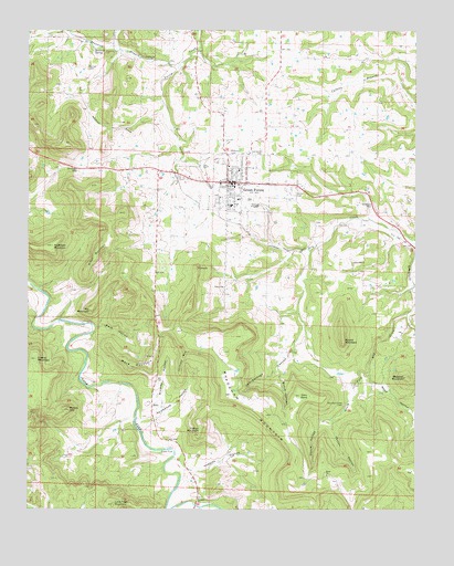
Green Forest, AR USGS Topographic Map
Click on map above to begin viewing in our Map Viewer.

This topographic map contains these locations and features:
Feature Name Type Latitude Longitude GNIS ID View Map
Anderson MountainSummitN36.3187°W93.4924°45869View Map
Blacklick MountainSummitN36.2848°W93.3785°57388View Map
Bradshaw MountainSummitN36.2748°W93.4232°46905View Map
Brasswell Spring (historical)Populated PlaceN36.3715°W93.4730°69194View Map
Braswell BranchStreamN36.3656°W93.4519°46918View Map
Braswell SpringSpringN36.3701°W93.4787°46919View Map
Braswell Springs School (historical)SchoolN36.3717°W93.4732°69195View Map
Brawley HollowValleyN36.2781°W93.4574°46921View Map
Bunch CanyonValleyN36.2837°W93.4182°47181View Map
Burris CemeteryCemeteryN36.3653°W93.4810°47216View Map
City of Green ForestCivilN36.3344°W93.4280°2403736View Map
Collier MountainSummitN36.2698°W93.4446°47929View Map
Crystal MountainSummitN36.2892°W93.4974°48245View Map
Devils PocketValleyN36.2717°W93.4063°48496View Map
First Baptist ChurchChurchN36.3359°W93.4382°1959669View Map
Glenwood CemeteryCemeteryN36.3417°W93.4257°49451View Map
Green ForestPopulated PlaceN36.3353°W93.4360°49632View Map
Green ForestForestN36.3353°W93.4360°67016View Map
Green Forest Elementary SchoolSchoolN36.3310°W93.4319°69218View Map
Green Forest High SchoolSchoolN36.3291°W93.4345°69219View Map
Green Forest Police DepartmentBuildingN36.3344°W93.4342°2118856View Map
Green Forest Volunteer Fire DepartmentBuildingN36.3342°W93.4303°2116502View Map
Green Forrest Intermediate SchoolSchoolN36.3298°W93.4328°2039015View Map
Hoppins HollowValleyN36.2601°W93.4452°50316View Map
Jackson MountainSummitN36.2895°W93.4499°57977View Map
Jennings GapGapN36.3392°W93.4844°50622View Map
Lone Tree MountainSummitN36.2512°W93.4724°51406View Map
Mack HollowValleyN36.2978°W93.4760°51589View Map
Mack MountainSummitN36.2876°W93.4669°51590View Map
Mead HollowValleyN36.2823°W93.3869°51887View Map
Mill MountainSummitN36.3023°W93.4796°58183View Map
Miller MountainSummitN36.3184°W93.4769°58188View Map
Mountain View CemeteryCemeteryN36.2773°W93.3982°52502View Map
New Town (historical)Populated PlaceN36.3231°W93.4363°69232View Map
Norris CemeteryCemeteryN36.3323°W93.4141°52798View Map
Norton (historical)Populated PlaceN36.3381°W93.4535°69233View Map
Paxton HollowValleyN36.2712°W93.4016°53234View Map
Pickens CemeteryCemeteryN36.3426°W93.4357°53343View Map
PinnacleSummitN36.3131°W93.4457°58390View Map
Potato HillSummitN36.2759°W93.4869°53725View Map
Round MountainSummitN36.2940°W93.3985°58543View Map
RulePopulated PlaceN36.2778°W93.4599°58557View Map
Rule CemeteryCemeteryN36.2728°W93.4605°1959675View Map
Rule School (historical)SchoolN36.2734°W93.4599°69241View Map
Saint John's Emergency Medical Service Carroll CountyBuildingN36.3341°W93.4303°2119202View Map
Schriborough CanyonValleyN36.2906°W93.4160°54629View Map
Sims PointSummitN36.2798°W93.4121°54872View Map
Spicewood HollowValleyN36.2740°W93.4599°55067View Map
Township of HickoryCivilN36.3483°W93.4240°66899View Map
Township of LibertyCivilN36.2617°W93.4469°66901View Map
Trinity Free Will Baptist ChurchChurchN36.3315°W93.4382°1959677View Map
Union ChurchChurchN36.3081°W93.4371°55806View Map
Ward CemeteryCemeteryN36.2592°W93.4068°1959678View Map
Ward ChurchChurchN36.2595°W93.4041°56044View Map
Zion Hill CemeteryCemeteryN36.3156°W93.3955°1959679View Map
Zion Hill ChurchChurchN36.3145°W93.3949°56648View Map

Note: Coordinates in the location and feature list above are referenced to NAD83 datum.


Copyright (C) 2008-2024 Ryan Niemi / Sunset Dynamics ... All Rights Reserved