TopoQuest Logo
Do you find TopoQuest useful?
Help keep TopoQuest running and adding new maps/features by donating!
Bitcoin:  19c7KJd3qBynnjoSw5npx9KScwjBe4ifkT
Litecoin:  LXs6TkuXGGXo1vDsWCkWVdjQX94eUKd6ui
Home View Maps Find Maps Find Places Resources & Links


Osage, Arkansas Topographic Map

USGS Map Title: Osage, AR
USGS Map MRC: 36093B4
DRG (GeoTIFF) Download: o36093b4.tif


Neighboring USGS Topographic Map Quads:


  Berryville, AR  
36093C5
 

  Green Forest, AR  
36093C4
 

  Alpena, AR  
36093C3
 

  Marble, AR  
36093B5
 

  Osage, AR  
36093B4
 

  Osage NE, AR  
36093B3
 

  Kingston, AR  
36093A5
 

  Osage SW, AR  
36093A4
 

  Ponca, AR  
36093A3


Map MRC Location:

N37°
W94°
N37°
W93°
H8 H7 H6 H5 H4 H3 H2 H1
G8 G7 G6 G5 G4 G3 G2 G1
F8 F7 F6 F5 F4 F3 F2 F1
E8 E7 E6 E5 E4 E3 E2 E1
D8 D7 D6 D5 D4 D3 D2 D1
C8 C7 C6 C5 C4 C3 C2 C1
B8 B7 B6 B5 B4 B3 B2 B1
A8 A7 A6 A5 A4 A3 A2 A1
N36°
W94°
N36°
W93°

Osage, AR USGS 1:24K Topographic Map Preview:
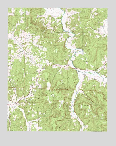
Osage, AR USGS Topographic Map
Click on map above to begin viewing in our Map Viewer.

This topographic map contains these locations and features:
Feature Name Type Latitude Longitude GNIS ID View Map
Assembly of God ChurchChurchN36.1867°W93.3982°69189View Map
Black MountainSummitN36.2309°W93.4638°46673View Map
Bobo CemeteryCemeteryN36.2328°W93.3785°46788View Map
Brown HollowValleyN36.1356°W93.4660°47007View Map
Cedar BluffCliffN36.1990°W93.4244°47565View Map
Chaney CemeteryCemeteryN36.2148°W93.4252°47688View Map
Coffman MountainSummitN36.1515°W93.4010°57564View Map
ConnerPopulated PlaceN36.2412°W93.4449°57579View Map
Dewees MountainSummitN36.1806°W93.4799°57649View Map
Dog BranchStreamN36.1854°W93.3896°48551View Map
DryforkPopulated PlaceN36.1534°W93.4891°76826View Map
Fancher CemeteryCemeteryN36.1773°W93.3891°49003View Map
Fultz MountainSummitN36.2098°W93.4938°57778View Map
GobblerPopulated PlaceN36.1887°W93.4563°57033View Map
Gobbler CemeteryCemeteryN36.1881°W93.4593°1959670View Map
Gobbler ChurchChurchN36.1884°W93.4588°49463View Map
Gobbler PointSummitN36.1854°W93.4663°77032View Map
Hurth HollowValleyN36.1684°W93.4594°50466View Map
Jim Fultz MountainSummitN36.1745°W93.4327°50649View Map
Jody HollowValleyN36.1631°W93.4707°50656View Map
Kenner BranchStreamN36.1720°W93.4141°50809View Map
Kenner CreekStreamN36.1865°W93.4130°50810View Map
Lake of No ReturnReservoirN36.1901°W93.3752°79655View Map
Lake of No Return DamDamN36.1901°W93.3752°79654View Map
McGehee CemeteryCemeteryN36.2378°W93.3880°51840View Map
Miller HollowValleyN36.1901°W93.4321°52066View Map
Miller HollowValleyN36.1406°W93.4196°52068View Map
North Fork Dry ForkStreamN36.1540°W93.4935°72886View Map
OsagePopulated PlaceN36.1826°W93.4046°77924View Map
Pine HollowValleyN36.2262°W93.4305°53445View Map
RuddPopulated PlaceN36.2137°W93.4860°78226View Map
Rudd School (historical)SchoolN36.2165°W93.4794°69240View Map
Saffer MountainSummitN36.1715°W93.4480°58566View Map
Sally HollowValleyN36.1670°W93.4166°54511View Map
Sisco CemeteryCemeteryN36.1795°W93.4046°54876View Map
Sites CemeteryCemeteryN36.1659°W93.4721°54880View Map
Sites CemeteryCemeteryN36.1759°W93.3799°54881View Map
Snead CemeteryCemeteryN36.1901°W93.3835°54979View Map
South Carroll County Volunteer Fire Department Station 1BuildingN36.2042°W93.4792°2117137View Map
South Carroll County Volunteer Fire Department SubstationBuildingN36.1790°W93.4046°2117138View Map
Tan Yard BranchStreamN36.1556°W93.4882°55423View Map
Township of Dry ForkCivilN36.1523°W93.4913°66897View Map
Township of OsageCivilN36.1661°W93.3759°66905View Map
Township of PineyCivilN36.2146°W93.4829°66907View Map
Usrey MountainSummitN36.2090°W93.4382°55864View Map
Waldrop MountainSummitN36.2267°W93.4563°58815View Map
York CemeteryCemeteryN36.2048°W93.4032°56606View Map

Note: Coordinates in the location and feature list above are referenced to NAD83 datum.


Copyright (C) 2008-2025 Ryan Niemi / Sunset Dynamics ... All Rights Reserved