TopoQuest Logo
Do you find TopoQuest useful?
Help keep TopoQuest running and adding new maps/features by donating!
Bitcoin:  19c7KJd3qBynnjoSw5npx9KScwjBe4ifkT
Litecoin:  LXs6TkuXGGXo1vDsWCkWVdjQX94eUKd6ui
Home View Maps Find Maps Find Places Resources & Links


Grove Center, Kentucky Topographic Map

USGS Map Title: Grove Center, KY
USGS Map MRC: 37088F1
DRG (GeoTIFF) Download: o37088f1.tif


Neighboring USGS Topographic Map Quads:


  New Haven SW, IL  
37088G2
 

  Wabash Island, KY  
37088G1
 

  Uniontown, KY  
37087G8
 

  Shawneetown, IL  
37088F2
 

  Grove Center, KY  
37088F1
 

  Morganfield, KY  
37087F8
 

  Saline Mines, IL  
37088E2
 

  Dekoven, KY  
37088E1
 

  Sturgis, KY  
37087E8


Map MRC Location:

N38°
W89°
N38°
W88°
H8 H7 H6 H5 H4 H3 H2 H1
G8 G7 G6 G5 G4 G3 G2 G1
F8 F7 F6 F5 F4 F3 F2 F1
E8 E7 E6 E5 E4 E3 E2 E1
D8 D7 D6 D5 D4 D3 D2 D1
C8 C7 C6 C5 C4 C3 C2 C1
B8 B7 B6 B5 B4 B3 B2 B1
A8 A7 A6 A5 A4 A3 A2 A1
N37°
W89°
N37°
W88°

Grove Center, KY USGS 1:24K Topographic Map Preview:
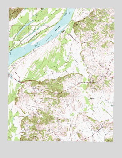
Grove Center, KY USGS Topographic Map
Click on map above to begin viewing in our Map Viewer.

This topographic map contains these locations and features:
Feature Name Type Latitude Longitude GNIS ID View Map
Bald HillSummitN37.6673°W88.0636°486261View Map
Bell IslandIslandN37.7250°W88.0856°486794View Map
Big LakeLakeN37.7320°W88.1059°404416View Map
Black LakeLakeN37.7432°W88.0941°404491View Map
BlackburnPopulated PlaceN37.6956°W88.1203°507519View Map
Fish LakeLakeN37.7286°W88.0938°408385View Map
Geiger LakeLakeN37.6450°W88.1188°492764View Map
Goose Pond (historical)ReservoirN37.6952°W88.0705°2743580View Map
Goose Pond DitchCanalN37.6828°W88.0981°512350View Map
Grove CenterPopulated PlaceN37.6398°W88.0131°493430View Map
Grundy HillSummitN37.7342°W88.0461°493452View Map
Harding PondSwampN37.6589°W88.0017°493725View Map
Millrace SloughStreamN37.7095°W88.1225°413620View Map
Mount Olive (historical)Populated PlaceN37.6290°W88.0901°2743588View Map
Mount Olive ChurchChurchN37.6287°W88.0909°498793View Map
Mullin Pond (historical)LakeN37.6656°W88.0278°499087View Map
RaleighPopulated PlaceN37.7278°W88.0595°508895View Map
Shiloh ChurchChurchN37.6450°W88.0653°503380View Map
Spring GrovePopulated PlaceN37.6809°W88.0275°504140View Map
The RocksPopulated PlaceN37.6748°W88.0936°505142View Map
Township of ShawneeCivilN37.7439°W88.1122°429737View Map
Wash CreekStreamN37.6264°W88.0489°506244View Map
Welsh Lake (historical)LakeN37.7448°W88.0606°1811010View Map
Woodland ChurchChurchN37.6870°W88.0134°507097View Map
Zion ChurchChurchN37.7173°W88.0189°507286View Map

Note: Coordinates in the location and feature list above are referenced to NAD83 datum.


Copyright (C) 2008-2025 Ryan Niemi / Sunset Dynamics ... All Rights Reserved