TopoQuest Logo
Do you find TopoQuest useful?
Help keep TopoQuest running and adding new maps/features by donating!
Bitcoin:  19c7KJd3qBynnjoSw5npx9KScwjBe4ifkT
Litecoin:  LXs6TkuXGGXo1vDsWCkWVdjQX94eUKd6ui
Home View Maps Find Maps Find Places Resources & Links


Queen, New Mexico Topographic Map

USGS Map Title: Queen, NM
USGS Map MRC: 32104B6
DRG (GeoTIFF) Download: o32104b6.tif


Neighboring USGS Topographic Map Quads:


  Ares Peak, NM  
32104C7
 

  Red Bluff Draw, NM  
32104C6
 

  Bandanna Point, NM  
32104C5
 

  Pickett Hill, NM  
32104B7
 

  Queen, NM  
32104B6
 

  Serpentine Bends, NM  
32104B5
 

  El Paso Gap, NM  
32104A7
 

  Gunsight Canyon, NM  
32104A6
 

  Grapevine Draw, NM  
32104A5


Map MRC Location:

N33°
W105°
N33°
W104°
H8 H7 H6 H5 H4 H3 H2 H1
G8 G7 G6 G5 G4 G3 G2 G1
F8 F7 F6 F5 F4 F3 F2 F1
E8 E7 E6 E5 E4 E3 E2 E1
D8 D7 D6 D5 D4 D3 D2 D1
C8 C7 C6 C5 C4 C3 C2 C1
B8 B7 B6 B5 B4 B3 B2 B1
A8 A7 A6 A5 A4 A3 A2 A1
N32°
W105°
N32°
W104°

Queen, NM USGS 1:24K Topographic Map Preview:
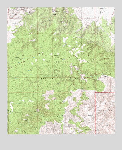
Queen, NM USGS Topographic Map
Click on map above to begin viewing in our Map Viewer.

This topographic map contains these locations and features:
Feature Name Type Latitude Longitude GNIS ID View Map
Bearup WellWellN32.1571°W104.6844°903699View Map
Carson SeepSpringN32.1387°W104.7275°904815View Map
Corriente Cattle CompanyLocaleN32.1571°W104.7458°1983815View Map
Cottonwood CanyonValleyN32.1449°W104.6870°905406View Map
Cottonwood Storage TankReservoirN32.1254°W104.6855°1993978View Map
Cottonwood WellWellN32.1254°W104.6855°905432View Map
Cowboy TankReservoirN32.1679°W104.6905°905456View Map
Dinner HillSummitN32.1434°W104.6544°905770View Map
East WellWellN32.2343°W104.7177°905995View Map
Gilson SpringSpringN32.2358°W104.6861°906554View Map
Guadalupe Administrative SiteLocaleN32.2026°W104.6905°928954View Map
Guadalupe Church CampLocaleN32.2007°W104.7372°906761View Map
Hamilton WellWellN32.2484°W104.6383°906816View Map
Horse CanyonValleyN32.1698°W104.6634°907087View Map
Horse SpringSpringN32.1401°W104.6650°907106View Map
Horse WellWellN32.1701°W104.6638°907114View Map
Huapache CanyonValleyN32.2369°W104.6471°907133View Map
Juniper LakeLakeN32.1963°W104.6577°907488View Map
Juniper WellWellN32.1984°W104.6505°907498View Map
Kellar LakeLakeN32.2138°W104.6834°907515View Map
Kirkland CanyonValleyN32.1718°W104.6253°907565View Map
Kirkland SeepSpringN32.1516°W104.6435°907566View Map
Kite WindmillLocaleN32.1626°W104.7097°907570View Map
Kite Windmill Storage TankReservoirN32.1626°W104.7097°1993985View Map
Pats LakeLakeN32.2107°W104.7106°909505View Map
Payne CanyonValleyN32.1620°W104.6600°909520View Map
Priestly TankReservoirN32.1881°W104.7253°909857View Map
Putman CabinLocaleN32.1293°W104.6463°909906View Map
QueenPopulated PlaceN32.1909°W104.7458°909922View Map
Queen CemeteryCemeteryN32.2001°W104.7338°909926View Map
Queen Post Office (historical)Post OfficeN32.1909°W104.7458°937895View Map
Queen Volunteer Fire DepartmentBuildingN32.1942°W104.7390°2657716View Map
Red LakeLakeN32.1984°W104.6852°910068View Map
Reed TankReservoirN32.1804°W104.7404°910105View Map
Robinson DrawValleyN32.1794°W104.7120°910355View Map
Rock TankReservoirN32.1751°W104.6907°910388View Map
Sitting Bull FallsFallsN32.2433°W104.6974°911096View Map
Sitting Bull Falls Point of InterestParkN32.2446°W104.6963°924236View Map
Sitting Bull Recreation AreaAreaN32.2454°W104.6952°911097View Map
Sitting Bull SpringSpringN32.2367°W104.7023°911098View Map
Taylor TankReservoirN32.1436°W104.6882°911564View Map
Thayer HillSummitN32.1947°W104.6358°911624View Map
The PinnacleSummitN32.1925°W104.6323°924237View Map
Turkey CanyonValleyN32.1858°W104.6657°911863View Map
Turkey WellWellN32.1804°W104.6772°911908View Map
Watkins TankReservoirN32.1475°W104.7160°912189View Map
White Oaks SpringSpringN32.2443°W104.7238°912316View Map

Note: Coordinates in the location and feature list above are referenced to NAD83 datum.


Copyright (C) 2008-2025 Ryan Niemi / Sunset Dynamics ... All Rights Reserved