TopoQuest Logo
Do you find TopoQuest useful?
Help keep TopoQuest running and adding new maps/features by donating!
Bitcoin:  19c7KJd3qBynnjoSw5npx9KScwjBe4ifkT
Litecoin:  LXs6TkuXGGXo1vDsWCkWVdjQX94eUKd6ui
Home View Maps Find Maps Find Places Resources & Links


Mingoville, Pennsylvania Topographic Map

USGS Map Title: Mingoville, PA
USGS Map MRC: 40077H6
DRG (GeoTIFF) Download: o40077h6.tif


Neighboring USGS Topographic Map Quads:


  Snow Shoe SE, PA  
41077A7
 

  Howard, PA  
41077A6
 

  Beech Creek, PA  
41077A5
 

  Bellefonte, PA  
40077H7
 

  Mingoville, PA  
40077H6
 

  Madisonburg, PA  
40077H5
 

  State College, PA  
40077G7
 

  Centre Hall, PA  
40077G6
 

  Spring Mills, PA  
40077G5


Map MRC Location:

N41°
W78°
N41°
W77°
H8 H7 H6 H5 H4 H3 H2 H1
G8 G7 G6 G5 G4 G3 G2 G1
F8 F7 F6 F5 F4 F3 F2 F1
E8 E7 E6 E5 E4 E3 E2 E1
D8 D7 D6 D5 D4 D3 D2 D1
C8 C7 C6 C5 C4 C3 C2 C1
B8 B7 B6 B5 B4 B3 B2 B1
A8 A7 A6 A5 A4 A3 A2 A1
N40°
W78°
N40°
W77°

Mingoville, PA USGS 1:24K Topographic Map Preview:
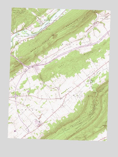
Mingoville, PA USGS Topographic Map
Click on map above to begin viewing in our Map Viewer.

This topographic map contains these locations and features:
Feature Name Type Latitude Longitude GNIS ID View Map
Antis RunStreamN40.9759°W77.7453°1168341View Map
Bald Eagle State ForestForestN40.8878°W77.6561°1168630View Map
Bierly (Personal Use) AirportAirportN40.9318°W77.7424°1194139View Map
Boy School (historical)SchoolN40.9717°W77.6642°1196783View Map
Bullit RunStreamN40.9890°W77.7097°1170660View Map
CurtinPopulated PlaceN40.9723°W77.7439°1203382View Map
Curtin GapGapN40.9484°W77.7372°1172852View Map
Curtin Gap QuarryMineN40.9425°W77.7114°2706946View Map
Diehls HollowValleyN40.9997°W77.6459°1173265View Map
Dopps HollowValleyN40.9988°W77.7308°1173389View Map
Emmanuel ChurchChurchN40.9912°W77.6342°1174239View Map
Fishing Creek SchoolSchoolN40.9156°W77.7283°1196785View Map
ForestPopulated PlaceN40.9248°W77.6892°1196781View Map
Gentzel School (historical)SchoolN40.8917°W77.7033°1196786View Map
Greens ValleyValleyN40.9211°W77.6387°1176167View Map
Hecla GapGapN40.9212°W77.6386°1176754View Map
Hecla ParkParkN40.9309°W77.6453°1176755View Map
Henderson SchoolSchoolN40.9526°W77.7039°1196784View Map
Howard DamDamN40.9984°W77.6464°1195191View Map
Howard GapGapN40.9981°W77.6439°1177519View Map
Howard State NurseryForestN40.9870°W77.7144°1192639View Map
JacksonvillePopulated PlaceN40.9923°W77.6319°1177941View Map
Jacksonville Census Designated PlaceCensusN40.9920°W77.6340°2584473View Map
Kennedy ChurchChurchN40.9856°W77.7089°1178367View Map
Lambs GapGapN40.9745°W77.6947°1178831View Map
Little Nittany ValleyValleyN40.9440°W77.7309°1179625View Map
Logan GapGapN40.8903°W77.6275°1179812View Map
Logan SchoolSchoolN40.8778°W77.6278°1196782View Map
LyonstownPopulated PlaceN40.9376°W77.7425°1180143View Map
MingovillePopulated PlaceN40.9323°W77.6481°1181335View Map
Mingoville Census Designated PlaceCensusN40.9370°W77.6597°2584487View Map
Mingoville Post OfficePost OfficeN40.9359°W77.6487°2773210View Map
Mingoville Post Office (historical)Post OfficeN40.9234°W77.6464°1214232View Map
Mount EaglePopulated PlaceN40.9820°W77.7056°1181684View Map
Mount Eagle Census Designated PlaceCensusN40.9800°W77.7058°2584490View Map
Nittany Country ClubLocaleN40.9298°W77.6511°1213297View Map
Nittany CreekStreamN40.9739°W77.7428°1182481View Map
Nittany Wildland FirefightersBuildingN40.9126°W77.6794°2645867View Map
Oak Grove SchoolSchoolN40.9340°W77.7433°1196787View Map
Rag ValleyValleyN40.9215°W77.6385°1184595View Map
Sand RidgeRidgeN40.9523°W77.6636°1175527View Map
Sand Rock TrailTrailN40.9523°W77.6636°1193284View Map
Township of MarionCivilN40.9858°W77.6426°1216131View Map
Township of SpringCivilN40.8949°W77.7330°1216138View Map
Walker Township Volunteer Fire Company 16 Zion StationBuildingN40.9127°W77.6794°2645869View Map
ZionPopulated PlaceN40.9142°W77.6847°1191960View Map
Zion Census Designated PlaceCensusN40.9168°W77.6908°2390556View Map

Note: Coordinates in the location and feature list above are referenced to NAD83 datum.


Copyright (C) 2008-2025 Ryan Niemi / Sunset Dynamics ... All Rights Reserved