TopoQuest Logo
Do you find TopoQuest useful?
Help keep TopoQuest running and adding new maps/features by donating!
Bitcoin:  19c7KJd3qBynnjoSw5npx9KScwjBe4ifkT
Litecoin:  LXs6TkuXGGXo1vDsWCkWVdjQX94eUKd6ui
Home View Maps Find Maps Find Places Resources & Links


Bellefonte, Pennsylvania Topographic Map

USGS Map Title: Bellefonte, PA
USGS Map MRC: 40077H7
DRG (GeoTIFF) Download: o40077h7.tif


Neighboring USGS Topographic Map Quads:


  Snow Shoe, PA  
41077A8
 

  Snow Shoe SE, PA  
41077A7
 

  Howard, PA  
41077A6
 

  Bear Knob, PA  
40077H8
 

  Bellefonte, PA  
40077H7
 

  Mingoville, PA  
40077H6
 

  Julian, PA  
40077G8
 

  State College, PA  
40077G7
 

  Centre Hall, PA  
40077G6


Map MRC Location:

N41°
W78°
N41°
W77°
H8 H7 H6 H5 H4 H3 H2 H1
G8 G7 G6 G5 G4 G3 G2 G1
F8 F7 F6 F5 F4 F3 F2 F1
E8 E7 E6 E5 E4 E3 E2 E1
D8 D7 D6 D5 D4 D3 D2 D1
C8 C7 C6 C5 C4 C3 C2 C1
B8 B7 B6 B5 B4 B3 B2 B1
A8 A7 A6 A5 A4 A3 A2 A1
N40°
W78°
N40°
W77°

Bellefonte, PA USGS 1:24K Topographic Map Preview:
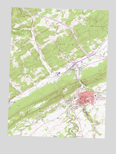
Bellefonte, PA USGS Topographic Map
Click on map above to begin viewing in our Map Viewer.

This topographic map contains these locations and features:
Feature Name Type Latitude Longitude GNIS ID View Map
Advent ChurchChurchN40.9762°W77.8128°1168088View Map
AxemannPopulated PlaceN40.8901°W77.7603°1168535View Map
Axemann SpringSpringN40.8901°W77.7600°1202447View Map
Bald Eagle Area Middle - Senior High SchoolSchoolN40.9372°W77.8111°1168627View Map
Bald Eagle Mine StationLocaleN40.9259°W77.8319°1212636View Map
BellefontePopulated PlaceN40.9134°W77.7783°1169165View Map
Bellefonte AirportAirportN40.8889°W77.8118°1194130View Map
Bellefonte Emergency Medical Services Company 26BuildingN40.9085°W77.7822°2719552View Map
Bellefonte Police DepartmentBuildingN40.9143°W77.7820°2776900View Map
Bellefonte Post OfficePost OfficeN40.9132°W77.7780°2772591View Map
Bellefonte StationLocaleN40.9195°W77.7881°1212635View Map
Big SpringPopulated PlaceN40.9092°W77.7811°1203091View Map
Bishop Street SchoolSchoolN40.9115°W77.7728°1169673View Map
Borough of BellefonteCivilN40.9141°W77.7683°1215054View Map
Borough of MilesburgCivilN40.9425°W77.7919°1215057View Map
Brower HollowValleyN40.9252°W77.8411°1170358View Map
Brower Hollow RunStreamN40.9217°W77.8381°1202610View Map
Buffalo RunStreamN40.9167°W77.7858°1170618View Map
Buffalo Run ChurchChurchN40.8751°W77.8478°1170620View Map
Bush AdditionPopulated PlaceN40.9048°W77.7889°1170761View Map
Bush HollowValleyN40.9174°W77.8594°1170764View Map
Bush Hollow RunStreamN40.9139°W77.8533°1202611View Map
Central CityPopulated PlaceN40.9501°W77.7967°1171482View Map
Centre CountyCivilN40.9193°W77.8200°1214720View Map
Centre County Sheriff's OfficeBuildingN40.9126°W77.7753°2776977View Map
Chemical StationLocaleN40.8989°W77.8514°1212637View Map
Citizen's Fire Company 9BuildingN40.9430°W77.7821°2645897View Map
ColevillePopulated PlaceN40.9095°W77.7969°1172202View Map
Commonwealth of PennsylvaniaCivilN40.8967°W77.8389°1779798View Map
Dewitt RunStreamN40.9039°W77.8736°1173219View Map
Dry TopPopulated PlaceN40.9567°W77.7964°1203452View Map
East EndPopulated PlaceN40.9137°W77.7533°1173800View Map
Fairview ChurchChurchN40.9967°W77.7814°1174523View Map
FetzertownPopulated PlaceN40.9889°W77.8275°1174726View Map
Fishermans ParadisePopulated PlaceN40.8806°W77.7928°1203572View Map
Forge Union ChurchChurchN40.9031°W77.7769°1174988View Map
Forked SpringSpringN40.8801°W77.7942°1202446View Map
Gum StumpPopulated PlaceN40.9803°W77.8494°1176314View Map
Holt HollowValleyN40.9565°W77.7748°1177238View Map
Holt RunStreamN40.9539°W77.7672°1201553View Map
Kelley SpringSpringN40.9048°W77.7778°1201482View Map
Knox SchoolSchoolN40.8859°W77.8289°1196977View Map
Logan BranchStreamN40.9098°W77.7842°1192831View Map
Logan Fire Company 1BuildingN40.9134°W77.7771°2645494View Map
MilesburgPopulated PlaceN40.9417°W77.7850°1181104View Map
Milesburg Post OfficePost OfficeN40.9422°W77.7857°2772834View Map
Moose RunStreamN40.9420°W77.7914°1181525View Map
Morris (historical)LocaleN40.8992°W77.8172°1197038View Map
New Bush Hollow ChurchChurchN40.9234°W77.8672°1182296View Map
Park View HeightsPopulated PlaceN40.9178°W77.7581°1183309View Map
Pennsylvania State Police Troop G Rockview StationBuildingN40.9357°W77.8103°2776937View Map
Pleasant ViewPopulated PlaceN40.9262°W77.7783°1184083View Map
RunvillePopulated PlaceN40.9645°W77.8400°1185623View Map
Runville Post Office (historical)Post OfficeN40.9645°W77.8400°1214308View Map
Saint Johns CemeteryCemeteryN40.9112°W77.7696°1186074View Map
Saint Johns SchoolSchoolN40.9106°W77.7764°1186182View Map
Spring CreekStreamN40.9431°W77.7872°1188220View Map
Spring Creek GapGapN40.9297°W77.7833°2512544View Map
State Game Lands Number 92ParkN40.9851°W77.7625°1188541View Map
StevensPopulated PlaceN40.8926°W77.8322°1196976View Map
Township of BoggsCivilN40.9907°W77.7998°1216119View Map
Trcziyulny CemeteryCemeteryN40.9493°W77.7948°1189732View Map
Trcziyulny MountainSummitN40.9328°W77.7608°1189733View Map
Undine Fire Company 2BuildingN40.9113°W77.7762°2645495View Map
Union CemeteryCemeteryN40.9139°W77.7728°1190113View Map
Valley ViewPopulated PlaceN40.8987°W77.8308°1190319View Map
Wallace RunStreamN40.9309°W77.8158°1190522View Map
WBLF-AM (Bellefonte)TowerN40.9034°W77.7681°1200465View Map
WingatePopulated PlaceN40.9348°W77.8139°1191597View Map
YarnellPopulated PlaceN40.9978°W77.8108°1191861View Map

Note: Coordinates in the location and feature list above are referenced to NAD83 datum.


Copyright (C) 2008-2025 Ryan Niemi / Sunset Dynamics ... All Rights Reserved