TopoQuest Logo
Do you find TopoQuest useful?
Help keep TopoQuest running and adding new maps/features by donating!
Bitcoin:  19c7KJd3qBynnjoSw5npx9KScwjBe4ifkT
Litecoin:  LXs6TkuXGGXo1vDsWCkWVdjQX94eUKd6ui
Home View Maps Find Maps Find Places Resources & Links


Bald Knob, Illinois Topographic Map

USGS Map Title: Bald Knob, IL
USGS Map MRC: 39089B3
DRG (GeoTIFF) Download: o39089b3.tif


Neighboring USGS Topographic Map Quads:


  Nokomis SW, IL  
39089C4
 

  Nokomis, IL  
39089C3
 

  Ohlman, IL  
39089C2
 

  Hillsboro, IL  
39089B4
 

  Bald Knob, IL  
39089B3
 

  Ramsey Lake, IL  
39089B2
 

  Coffeen, IL  
39089A4
 

  Fillmore, IL  
39089A3
 

  Bingham, IL  
39089A2


Map MRC Location:

N40°
W90°
N40°
W89°
H8 H7 H6 H5 H4 H3 H2 H1
G8 G7 G6 G5 G4 G3 G2 G1
F8 F7 F6 F5 F4 F3 F2 F1
E8 E7 E6 E5 E4 E3 E2 E1
D8 D7 D6 D5 D4 D3 D2 D1
C8 C7 C6 C5 C4 C3 C2 C1
B8 B7 B6 B5 B4 B3 B2 B1
A8 A7 A6 A5 A4 A3 A2 A1
N39°
W90°
N39°
W89°

Bald Knob, IL USGS 1:24K Topographic Map Preview:
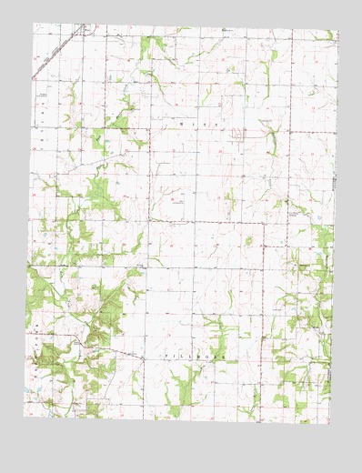
Bald Knob, IL USGS Topographic Map
Click on map above to begin viewing in our Map Viewer.

This topographic map contains these locations and features:
Feature Name Type Latitude Longitude GNIS ID View Map
Armentrout CemeteryCemeteryN39.2231°W89.3354°403616View Map
Bald KnobSummitN39.1753°W89.2651°403850View Map
Bost Hill CemeteryCemeteryN39.1454°W89.3334°1953387View Map
Bost Hill ChurchChurchN39.1453°W89.3329°404709View Map
Bost Hill School (historical)SchoolN39.1512°W89.3409°1772066View Map
Casey CemeteryCemeteryN39.1611°W89.2706°405673View Map
College Hill School (historical)SchoolN39.1517°W89.3070°1772074View Map
Eddington Dairy FarmLocaleN39.2031°W89.3611°2680756View Map
Gooseneck CemeteryCemeteryN39.2343°W89.3270°1953456View Map
Hoehn RLA AirportAirportN39.2192°W89.3318°2679108View Map
Knowles School (historical)SchoolN39.1514°W89.2687°1772098View Map
McNeely Landing Strip (historical)AirportN39.2278°W89.3684°1772109View Map
O K Flying Club Inc AirportAirportN39.1909°W89.3117°427278View Map
Olive Branch School (historical)SchoolN39.1884°W89.3162°1772127View Map
Pleasant Hill School (historical)SchoolN39.2139°W89.3540°1772132View Map
Pleasant View School (historical)SchoolN39.2395°W89.3251°1772134View Map
Prairie College School (historical)SchoolN39.2470°W89.2787°1772137View Map
Prairie View School (historical)SchoolN39.2170°W89.2690°1772139View Map
Sandy Bend School (historical)SchoolN39.1917°W89.2692°1772146View Map
Starr School (historical)SchoolN39.2031°W89.3076°1772153View Map
Township of FillmoreCivilN39.1299°W89.3069°429002View Map
Township of WittCivilN39.2174°W89.3072°429948View Map
Witt CemeteryCemeteryN39.2442°W89.3394°1953477View Map
Woodside CemeteryCemeteryN39.1730°W89.3285°1953397View Map
Woodside ChurchChurchN39.1731°W89.3281°421487View Map

Note: Coordinates in the location and feature list above are referenced to NAD83 datum.


Copyright (C) 2008-2025 Ryan Niemi / Sunset Dynamics ... All Rights Reserved