TopoQuest Logo
Do you find TopoQuest useful?
Help keep TopoQuest running and adding new maps/features by donating!
Bitcoin:  19c7KJd3qBynnjoSw5npx9KScwjBe4ifkT
Litecoin:  LXs6TkuXGGXo1vDsWCkWVdjQX94eUKd6ui
Home View Maps Find Maps Find Places Resources & Links


Julian, Pennsylvania Topographic Map

USGS Map Title: Julian, PA
USGS Map MRC: 40077G8
DRG (GeoTIFF) Download: o40077g8.tif


Neighboring USGS Topographic Map Quads:


  Black Moshannon, PA  
40078H1
 

  Bear Knob, PA  
40077H8
 

  Bellefonte, PA  
40077H7
 

  Port Matilda, PA  
40078G1
 

  Julian, PA  
40077G8
 

  State College, PA  
40077G7
 

  Franklinville, PA  
40078F1
 

  Pine Grove Mills, PA  
40077F8
 

  McAlevys Fort, PA  
40077F7


Map MRC Location:

N41°
W78°
N41°
W77°
H8 H7 H6 H5 H4 H3 H2 H1
G8 G7 G6 G5 G4 G3 G2 G1
F8 F7 F6 F5 F4 F3 F2 F1
E8 E7 E6 E5 E4 E3 E2 E1
D8 D7 D6 D5 D4 D3 D2 D1
C8 C7 C6 C5 C4 C3 C2 C1
B8 B7 B6 B5 B4 B3 B2 B1
A8 A7 A6 A5 A4 A3 A2 A1
N40°
W78°
N40°
W77°

Julian, PA USGS 1:24K Topographic Map Preview:
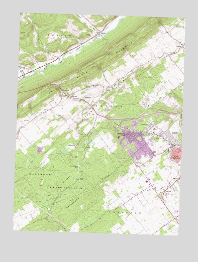
Julian, PA USGS Topographic Map
Click on map above to begin viewing in our Map Viewer.

This topographic map contains these locations and features:
Feature Name Type Latitude Longitude GNIS ID View Map
Alpha Fire Company 5 Patton StationBuildingN40.8125°W77.9209°2645669View Map
Altro (historical)LocaleN40.8228°W77.9028°1196982View Map
Bald Eagle LookoutLocaleN40.8351°W77.9744°1205142View Map
Bernel FarmLocaleN40.8494°W77.8850°2727815View Map
BloomsdorfPopulated PlaceN40.7567°W77.8831°1196981View Map
BriarlyPopulated PlaceN40.8509°W77.8964°1196984View Map
Buffalo RunPopulated PlaceN40.8284°W77.9622°1170615View Map
Campbell CemeteryCemeteryN40.8631°W77.9456°1171122View Map
Circle VillePopulated PlaceN40.7892°W77.9061°1171880View Map
Dillen Airport (historical)AirportN40.8434°W77.9831°1194116View Map
Eagle FieldAirportN40.8266°W77.9884°1194113View Map
FillmorePopulated PlaceN40.8589°W77.8764°1174751View Map
Gatesburg RidgeRidgeN40.7712°W77.9442°1175486View Map
Grays CemeteryCemeteryN40.8128°W77.9903°1176029View Map
Grays ChurchChurchN40.8198°W77.9761°1176030View Map
Guiser FarmsLocaleN40.7747°W77.9058°2727820View Map
Harner FarmsLocaleN40.7614°W77.8817°2727823View Map
Henderson CemeteryCemeteryN40.8642°W77.9992°1176824View Map
Ionosphere Research StationLocaleN40.7884°W77.9517°1177826View Map
JulianPopulated PlaceN40.8642°W77.9394°1178189View Map
Julian Census Designated PlaceCensusN40.8615°W77.9429°2389991View Map
Julian Post OfficePost OfficeN40.8648°W77.9411°2779668View Map
Kradel Acres FarmLocaleN40.8386°W77.8772°2727829View Map
KrumrinePopulated PlaceN40.8017°W77.8808°1196983View Map
Laurel RunStreamN40.8634°W77.9356°1192748View Map
MarysvillePopulated PlaceN40.7995°W77.9550°1180520View Map
Mattern Junction (historical)LocaleN40.8264°W77.9428°1196980View Map
MatternvillePopulated PlaceN40.8306°W77.9658°1180556View Map
Matternville SchoolSchoolN40.8262°W77.9519°1180557View Map
Mudlick RunStreamN40.8501°W77.9664°1182064View Map
Nittany ValleyValleyN40.8512°W77.8939°1182483View Map
Nittany ValleyValleyN40.7880°W77.9299°1182484View Map
Old Pine Hall CemeteryCemeteryN40.7743°W77.8885°2777546View Map
Overlook HeightsPopulated PlaceN40.8073°W77.8842°1183139View Map
Park Forest Elementary SchoolSchoolN40.8078°W77.9208°1207262View Map
Park Forest VillagePopulated PlaceN40.8067°W77.9169°1183297View Map
Park Forest Village Census Designated PlaceCensusN40.7999°W77.9081°2389641View Map
Park HillsPopulated PlaceN40.7976°W77.8992°1183300View Map
Patton Township Police DepartmentBuildingN40.8124°W77.9200°2781044View Map
Pine HallPopulated PlaceN40.7762°W77.8850°1183820View Map
Pine Hall CemeteryCemeteryN40.7782°W77.8845°2777542View Map
Radio Park Elementary SchoolSchoolN40.7992°W77.8839°1213896View Map
RidgemontPopulated PlaceN40.8281°W77.9486°1204505View Map
ScotiaPopulated PlaceN40.7998°W77.9461°1204595View Map
Silverdale School (historical)SchoolN40.8601°W77.9728°1196979View Map
State College Air DepotAirportN40.7709°W77.8789°1194097View Map
State College Area Junior High SchoolSchoolN40.8051°W77.9222°1207261View Map
State Game Lands Number 176ParkN40.7742°W77.9642°1188471View Map
Steel HollowValleyN40.8388°W77.9954°1193466View Map
StrublePopulated PlaceN40.7828°W77.8761°1188893View Map
The BarrensAreaN40.7670°W77.9792°1193524View Map
ToftreesPopulated PlaceN40.8260°W77.8811°2633699View Map
Toftrees Census Designated PlaceCensusN40.8248°W77.8848°2633698View Map
Toftrees Golf CourseLocaleN40.8284°W77.9039°1206565View Map
Township of HustonCivilN40.8684°W77.9767°1216129View Map
Township of PattonCivilN40.8258°W77.9237°1216133View Map
WaddlePopulated PlaceN40.8339°W77.9347°1198307View Map
Williams CemeteryCemeteryN40.8428°W77.9943°1191457View Map
Woodlawn Middle SchoolSchoolN40.8134°W77.8981°1213097View Map
WoodycrestPopulated PlaceN40.8131°W77.9025°1992800View Map
WQWK-FM (State College)TowerN40.8139°W77.8922°1200261View Map
WQWK-FM (University Park)TowerN40.8139°W77.8922°1200260View Map
WRSC-AM (State College)TowerN40.8139°W77.8922°1200455View Map
Ziggy's FieldAirportN40.8498°W77.9057°2442777View Map

Note: Coordinates in the location and feature list above are referenced to NAD83 datum.


Copyright (C) 2008-2024 Ryan Niemi / Sunset Dynamics ... All Rights Reserved