TopoQuest Logo
Do you find TopoQuest useful?
Help keep TopoQuest running and adding new maps/features by donating!
Bitcoin:  19c7KJd3qBynnjoSw5npx9KScwjBe4ifkT
Litecoin:  LXs6TkuXGGXo1vDsWCkWVdjQX94eUKd6ui
Home View Maps Find Maps Find Places Resources & Links


Colley, Pennsylvania Topographic Map

USGS Map Title: Colley, PA
USGS Map MRC: 41076E3
DRG (GeoTIFF) Download: o41076e3.tif


Neighboring USGS Topographic Map Quads:


  Monroeton, PA  
41076F4
 

  Wyalusing, PA  
41076F3
 

  Laceyville, PA  
41076F2
 

  Dushore, PA  
41076E4
 

  Colley, PA  
41076E3
 

  Jenningsville, PA  
41076E2
 

  Laporte, PA  
41076D4
 

  Lopez, PA  
41076D3
 

  Dutch Mountain, PA  
41076D2


Map MRC Location:

N42°
W77°
N42°
W76°
H8 H7 H6 H5 H4 H3 H2 H1
G8 G7 G6 G5 G4 G3 G2 G1
F8 F7 F6 F5 F4 F3 F2 F1
E8 E7 E6 E5 E4 E3 E2 E1
D8 D7 D6 D5 D4 D3 D2 D1
C8 C7 C6 C5 C4 C3 C2 C1
B8 B7 B6 B5 B4 B3 B2 B1
A8 A7 A6 A5 A4 A3 A2 A1
N41°
W77°
N41°
W76°

Colley, PA USGS 1:24K Topographic Map Preview:
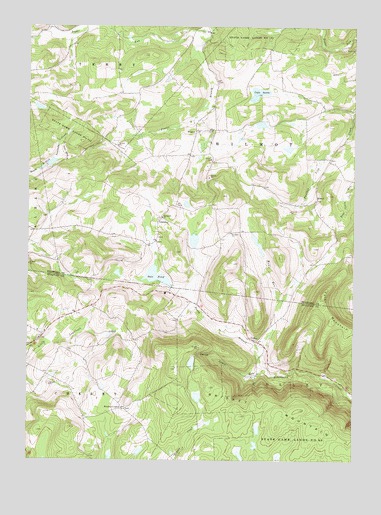
Colley, PA USGS Topographic Map
Click on map above to begin viewing in our Map Viewer.

This topographic map contains these locations and features:
Feature Name Type Latitude Longitude GNIS ID View Map
ColleyPopulated PlaceN41.5345°W76.2863°1172211View Map
Crane SwampLakeN41.6059°W76.2867°1172642View Map
CumiskeyPopulated PlaceN41.5690°W76.3238°1203377View Map
Cummiskey CemeteryCemeteryN41.5697°W76.3234°2776416View Map
EllwellPopulated PlaceN41.5751°W76.2635°1203512View Map
Elwell CemeteryCemeteryN41.5871°W76.2588°2776423View Map
Farr School (historical)SchoolN41.5945°W76.3105°1197358View Map
Foster BranchStreamN41.6231°W76.3052°1175034View Map
Kinsley CornersLocaleN41.5151°W76.3377°1178526View Map
New EraLocaleN41.6242°W76.3680°1212958View Map
Norconk CemeteryCemeteryN41.5644°W76.3248°2776471View Map
Pleasant Valley Fruit FarmLocaleN41.5765°W76.2899°1197357View Map
Saint Francis ChurchChurchN41.5701°W76.3224°1185942View Map
Saint Johns ChurchChurchN41.5656°W76.2960°1186165View Map
Saint Johns Lutheran CemeteryCemeteryN41.5661°W76.2972°2776426View Map
Saxe PondReservoirN41.5531°W76.3255°1187044View Map
Saxe Pond DamDamN41.5501°W76.3180°1195653View Map
Smith Cabin RunStreamN41.5270°W76.2833°1187856View Map
State Game Lands Number 142ParkN41.5948°W76.3583°1188449View Map
State Game Lands Number 172ParkN41.6237°W76.2872°1188469View Map
Township of WilmotCivilN41.5952°W76.2659°1216005View Map
Tyler MountainSummitN41.5479°W76.2610°1190045View Map
WilmotPopulated PlaceN41.5948°W76.3094°1204961View Map
Windfall School (historical)SchoolN41.6062°W76.3397°1197359View Map
Wolf RunStreamN41.5309°W76.2833°1191677View Map

Note: Coordinates in the location and feature list above are referenced to NAD83 datum.


Copyright (C) 2008-2025 Ryan Niemi / Sunset Dynamics ... All Rights Reserved