TopoQuest Logo
Do you find TopoQuest useful?
Help keep TopoQuest running and adding new maps/features by donating!
Bitcoin:  19c7KJd3qBynnjoSw5npx9KScwjBe4ifkT
Litecoin:  LXs6TkuXGGXo1vDsWCkWVdjQX94eUKd6ui
Home View Maps Find Maps Find Places Resources & Links


Log Spring, California Topographic Map

USGS Map Title: Log Spring, CA
USGS Map MRC: 39122G7
DRG (GeoTIFF) Download: o39122g7.tif


Neighboring USGS Topographic Map Quads:


  Buck Rock, CA  
39122H8
 

  Ball Mountain, CA  
39122H7
 

  Riley Ridge, CA  
39122H6
 

  Mendocino Pass, CA  
39122G8
 

  Log Spring, CA  
39122G7
 

  Hall Ridge, CA  
39122G6
 

  Plaskett Ridge, CA  
39122F8
 

  Plaskett Meadows, CA  
39122F7
 

  Alder Springs, CA  
39122F6


Map MRC Location:

N40°
W123°
N40°
W122°
H8 H7 H6 H5 H4 H3 H2 H1
G8 G7 G6 G5 G4 G3 G2 G1
F8 F7 F6 F5 F4 F3 F2 F1
E8 E7 E6 E5 E4 E3 E2 E1
D8 D7 D6 D5 D4 D3 D2 D1
C8 C7 C6 C5 C4 C3 C2 C1
B8 B7 B6 B5 B4 B3 B2 B1
A8 A7 A6 A5 A4 A3 A2 A1
N39°
W123°
N39°
W122°

Log Spring, CA USGS 1:24K Topographic Map Preview:
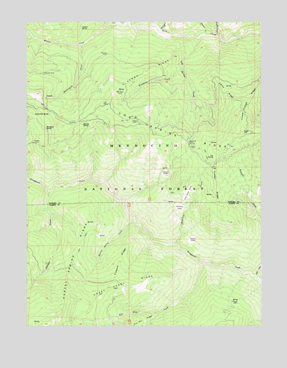
Log Spring, CA USGS Topographic Map
Click on map above to begin viewing in our Map Viewer.

This topographic map contains these locations and features:
Feature Name Type Latitude Longitude GNIS ID View Map
Beverly SpringSpringN39.8327°W122.8462°219103View Map
Blackjack Recreation SiteLocaleN39.8318°W122.8678°1655316View Map
Blackjack SpringSpringN39.8314°W122.8658°219422View Map
Board CreekStreamN39.8099°W122.8747°257301View Map
Bodkin CabinLocaleN39.8338°W122.8167°219579View Map
Buttermilk CreekStreamN39.8654°W122.8464°220304View Map
Buttermilk SpringSpringN39.8371°W122.8638°220306View Map
Cary Pasture CreekStreamN39.8715°W122.8044°258024View Map
Dead Mule CampLocaleN39.8465°W122.8267°1655124View Map
Dead Mule SpringSpringN39.8468°W122.8272°1666612View Map
Euchre GladeFlatN39.7846°W122.7892°223270View Map
Flowers RidgeRidgeN39.7763°W122.8267°223629View Map
Goat HillSummitN39.8296°W122.7603°224242View Map
Hamilton CreekStreamN39.7835°W122.7972°224836View Map
Hamilton GladeFlatN39.7982°W122.7961°224837View Map
Harvey Spring CreekStreamN39.7915°W122.8178°224994View Map
Harvey Spring RidgeRidgeN39.7840°W122.8464°224995View Map
Haypatch CreekStreamN39.8557°W122.7931°225066View Map
Hokey Pokey RidgeRidgeN39.7654°W122.8314°261413View Map
Horse Trough RidgeRidgeN39.8429°W122.7578°261514View Map
Kenny RidgeRidgeN39.8532°W122.8117°262139View Map
Kill Dry CreekStreamN39.7757°W122.7825°262173View Map
Lantz Cabin (historical)BuildingN39.8485°W122.7706°1666620View Map
Lantz RidgeRidgeN39.8463°W122.7697°262317View Map
Log SpringSpringN39.8194°W122.7762°262777View Map
Log Spring CreekStreamN39.8679°W122.7844°262778View Map
Log Spring RidgeRidgeN39.8277°W122.7942°262780View Map
Log Spring StationLocaleN39.8254°W122.7894°262781View Map
Mose Genot GladeFlatN39.8046°W122.7911°263855View Map
Murphy CanyonValleyN39.8688°W122.7744°263972View Map
One Bee CampLocaleN39.8260°W122.8692°264355View Map
Panther CreekStreamN39.8054°W122.8636°264479View Map
Poison GladeFlatN39.8138°W122.8017°264888View Map
Poison Glade Recreation SiteLocaleN39.8124°W122.8039°1655317View Map
Powell CabinLocaleN39.7599°W122.7664°265016View Map
Saturday CampLocaleN39.8618°W122.8328°265850View Map
Scott CreekStreamN39.7693°W122.7536°265939View Map
Side Rod CampLocaleN39.8538°W122.8667°266155View Map
Sugarfoot CreekStreamN39.8699°W122.7808°267858View Map
Sulphur SpringSpringN39.8724°W122.8467°267902View Map
SunnysidePopulated PlaceN39.8440°W122.8653°1659921View Map
Timber RidgeRidgeN39.8068°W122.7750°268288View Map
Willow CreekStreamN39.8740°W122.8308°269150View Map

Note: Coordinates in the location and feature list above are referenced to NAD83 datum.


Copyright (C) 2008-2024 Ryan Niemi / Sunset Dynamics ... All Rights Reserved