TopoQuest Logo
Do you find TopoQuest useful?
Help keep TopoQuest running and adding new maps/features by donating!
Bitcoin:  19c7KJd3qBynnjoSw5npx9KScwjBe4ifkT
Litecoin:  LXs6TkuXGGXo1vDsWCkWVdjQX94eUKd6ui
Home View Maps Find Maps Find Places Resources & Links


Pineville, Mississippi Topographic Map

USGS Map Title: Pineville, MS
USGS Map MRC: 32089B4
DRG (GeoTIFF) Download: o32089b4.tif


Neighboring USGS Topographic Map Quads:


  Pulaski, MS  
32089C5
 

  Forest, MS  
32089C4
 

  Lake, MS  
32089C3
 

  Homewood, MS  
32089B5
 

  Pineville, MS  
32089B4
 

  Clear Springs, MS  
32089B3
 

  Raleigh, MS  
32089A5
 

  Louin SW, MS  
32089A4
 

  Louin, MS  
32089A3


Map MRC Location:

N33°
W90°
N33°
W89°
H8 H7 H6 H5 H4 H3 H2 H1
G8 G7 G6 G5 G4 G3 G2 G1
F8 F7 F6 F5 F4 F3 F2 F1
E8 E7 E6 E5 E4 E3 E2 E1
D8 D7 D6 D5 D4 D3 D2 D1
C8 C7 C6 C5 C4 C3 C2 C1
B8 B7 B6 B5 B4 B3 B2 B1
A8 A7 A6 A5 A4 A3 A2 A1
N32°
W90°
N32°
W89°

Pineville, MS USGS 1:24K Topographic Map Preview:
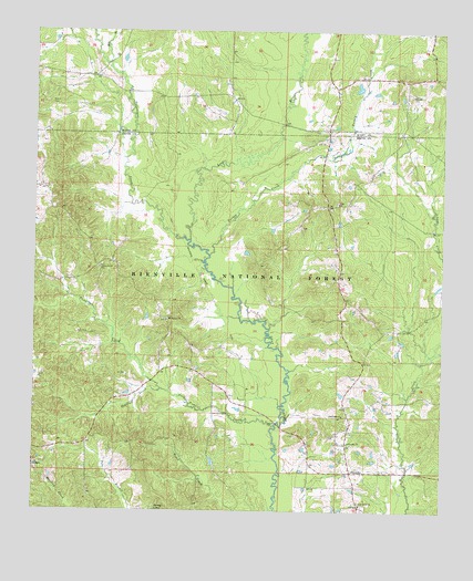
Pineville, MS USGS Topographic Map
Click on map above to begin viewing in our Map Viewer.

This topographic map contains these locations and features:
Feature Name Type Latitude Longitude GNIS ID View Map
Camp Grounds School (historical)SchoolN32.1796°W89.4026°704920View Map
Carr ChurchChurchN32.2054°W89.4070°692844View Map
Carr Methodist Church CemeteryCemeteryN32.2057°W89.4075°2766930View Map
Galilee ChurchChurchN32.2335°W89.3845°693281View Map
KleinPopulated PlaceN32.1765°W89.4612°704928View Map
Klein School (historical)SchoolN32.1715°W89.4573°704929View Map
Leaf River Baptist Church CemeteryCemeteryN32.1266°W89.3987°2766924View Map
Leaf River ChurchChurchN32.1268°W89.3998°693698View Map
Mill BranchStreamN32.2421°W89.4776°693972View Map
Mount Carmel CemeteryCemeteryN32.1751°W89.4591°2766926View Map
Mount Carmel ChurchChurchN32.1749°W89.4595°694054View Map
Noblin CemeteryCemeteryN32.2310°W89.4952°694202View Map
O T Gilbert Pond DamDamN32.2301°W89.4017°695428View Map
Oak Ridge ChurchChurchN32.1499°W89.4053°694240View Map
OthoPopulated PlaceN32.2354°W89.4084°704997View Map
PinevillePopulated PlaceN32.1352°W89.4028°694395View Map
Pineville Attendance CenterSchoolN32.1396°W89.4042°707256View Map
Pineville ChurchChurchN32.1432°W89.4037°694396View Map
Pineville Volunteer Fire DepartmentBuildingN32.1357°W89.4032°2667896View Map
Redhead CreekStreamN32.1565°W89.4615°694538View Map
Supervisor District 5CivilN32.1342°W89.4590°712074View Map
TallabogueStreamN32.1954°W89.4526°705671View Map
Tishkill CreekStreamN32.1477°W89.4262°694985View Map
Turkey CreekStreamN32.1918°W89.4465°695021View Map
Union Grove CemeteryCemeteryN32.1888°W89.4800°2766927View Map
Union Grove ChurchChurchN32.1879°W89.4801°695052View Map
Zula (historical)LocaleN32.1835°W89.3756°704938View Map

Note: Coordinates in the location and feature list above are referenced to NAD83 datum.


Copyright (C) 2008-2024 Ryan Niemi / Sunset Dynamics ... All Rights Reserved