TopoQuest Logo
Do you find TopoQuest useful?
Help keep TopoQuest running and adding new maps/features by donating!
Bitcoin:  19c7KJd3qBynnjoSw5npx9KScwjBe4ifkT
Litecoin:  LXs6TkuXGGXo1vDsWCkWVdjQX94eUKd6ui
Home View Maps Find Maps Find Places Resources & Links


Spotville, Arkansas Topographic Map

USGS Map Title: Spotville, AR
USGS Map MRC: 33093B1
DRG (GeoTIFF) Download: o33093b1.tif


Neighboring USGS Topographic Map Quads:


  Magnolia, AR  
33093C2
 

  Village, AR  
33093C1
 

  Mount Holly, AR  
33092C8
 

  Calhoun, AR  
33093B2
 

  Spotville, AR  
33093B1
 

  Marysville, AR  
33092B8
 

  Emerson, AR  
33093A2
 

  Emerson SE, AR  
33093A1
 

  Wesson SW, AR  
33092A8


Map MRC Location:

N34°
W94°
N34°
W93°
H8 H7 H6 H5 H4 H3 H2 H1
G8 G7 G6 G5 G4 G3 G2 G1
F8 F7 F6 F5 F4 F3 F2 F1
E8 E7 E6 E5 E4 E3 E2 E1
D8 D7 D6 D5 D4 D3 D2 D1
C8 C7 C6 C5 C4 C3 C2 C1
B8 B7 B6 B5 B4 B3 B2 B1
A8 A7 A6 A5 A4 A3 A2 A1
N33°
W94°
N33°
W93°

Spotville, AR USGS 1:24K Topographic Map Preview:
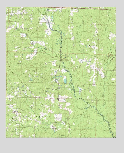
Spotville, AR USGS Topographic Map
Click on map above to begin viewing in our Map Viewer.

This topographic map contains these locations and features:
Feature Name Type Latitude Longitude GNIS ID View Map
Atlanta Oil and Gas FieldOilfieldN33.1726°W93.1102°45970View Map
Baker BranchStreamN33.2007°W93.0624°76222View Map
Baker CemeteryCemeteryN33.1918°W93.0796°46029View Map
Beech CreekStreamN33.1496°W93.0204°46317View Map
Bethel CemeteryCemeteryN33.1274°W93.0582°46425View Map
Bethel Church (historical)ChurchN33.1271°W93.0579°60228View Map
Bethlehem ChurchChurchN33.1896°W93.0185°60232View Map
Brushy BranchStreamN33.1374°W93.0763°76442View Map
Church of ChristChurchN33.1496°W93.1154°47774View Map
Harper CreekStreamN33.2415°W93.0785°49881View Map
Heard ChapelChurchN33.1326°W93.1129°49978View Map
Hurricane CreekStreamN33.1401°W93.0088°50443View Map
Jameson BridgeBridgeN33.1990°W93.0632°60230View Map
Little Cornie BayouStreamN33.2029°W93.0677°51226View Map
McClendon CemeteryCemeteryN33.1362°W93.1129°51794View Map
Nebo School (historical)SchoolN33.2465°W93.1138°60227View Map
NoxobePopulated PlaceN33.1454°W93.1043°58278View Map
Pine Tree Oil and Gas FieldOilfieldN33.1551°W93.0954°60224View Map
Riley BranchStreamN33.1346°W93.0082°54041View Map
Saint Marks CemeteryCemeteryN33.1962°W93.1127°54396View Map
Saint Marks Church (historical)ChurchN33.1960°W93.1121°60226View Map
Scott BranchStreamN33.1382°W93.0157°54636View Map
Slow Motion CreekStreamN33.1951°W93.0093°54917View Map
Smyrna ChurchChurchN33.1568°W93.1199°54966View Map
SpotvillePopulated PlaceN33.1907°W93.0207°58674View Map
Spotville School (historical)SchoolN33.2001°W93.0382°60231View Map
TalleyPopulated PlaceN33.1624°W93.0738°78521View Map
Talley School (historical)SchoolN33.1626°W93.0729°60229View Map
Tanyard BranchStreamN33.2362°W93.1210°83918View Map
Township of Calhoun (historical)CivilN33.2168°W93.1224°59963View Map
Township of Cornie (historical)CivilN33.2126°W93.0252°59965View Map
Village CreekStreamN33.1840°W93.0510°55910View Map
Village JunctionPopulated PlaceN33.2493°W93.0510°57223View Map
Zion Church (historical)ChurchN33.1760°W93.1035°60225View Map

Note: Coordinates in the location and feature list above are referenced to NAD83 datum.


Copyright (C) 2008-2025 Ryan Niemi / Sunset Dynamics ... All Rights Reserved