TopoQuest Logo
Do you find TopoQuest useful?
Help keep TopoQuest running and adding new maps/features by donating!
Bitcoin:  19c7KJd3qBynnjoSw5npx9KScwjBe4ifkT
Litecoin:  LXs6TkuXGGXo1vDsWCkWVdjQX94eUKd6ui
Home View Maps Find Maps Find Places Resources & Links


Cuthbert, Georgia Topographic Map

USGS Map Title: Cuthbert, GA
USGS Map MRC: 31084G7
DRG (GeoTIFF) Download: o31084g7.tif


Neighboring USGS Topographic Map Quads:


  Sanford, GA  
31084H8
 

  County Line, GA  
31084H7
 

  Benevolence, GA  
31084H6
 

  Morris, GA  
31084G8
 

  Cuthbert, GA  
31084G7
 

  Brooksville, GA  
31084G6
 

  Coleman, GA  
31084F8
 

  Carnegie, GA  
31084F7
 

  Martins Crossroads, GA  
31084F6


Map MRC Location:

N32°
W85°
N32°
W84°
H8 H7 H6 H5 H4 H3 H2 H1
G8 G7 G6 G5 G4 G3 G2 G1
F8 F7 F6 F5 F4 F3 F2 F1
E8 E7 E6 E5 E4 E3 E2 E1
D8 D7 D6 D5 D4 D3 D2 D1
C8 C7 C6 C5 C4 C3 C2 C1
B8 B7 B6 B5 B4 B3 B2 B1
A8 A7 A6 A5 A4 A3 A2 A1
N31°
W85°
N31°
W84°

Cuthbert, GA USGS 1:24K Topographic Map Preview:
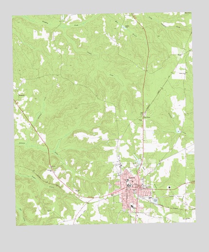
Cuthbert, GA USGS Topographic Map
Click on map above to begin viewing in our Map Viewer.

This topographic map contains these locations and features:
Feature Name Type Latitude Longitude GNIS ID View Map
Andrew CollegeSchoolN31.7724°W84.7946°354311View Map
Antioch Baptist ChurchChurchN31.7729°W84.7871°347480View Map
Bells Mill (historical)LocaleN31.7535°W84.7716°344718View Map
Bullock LakeReservoirN31.7992°W84.7934°337466View Map
Bullock Lake DamDamN31.7985°W84.7933°337465View Map
Butlers Mill (historical)LocaleN31.8679°W84.7988°352239View Map
Butlers PondReservoirN31.8668°W84.7973°312107View Map
Central JunctionLocaleN31.7629°W84.8249°344726View Map
City of CuthbertCivilN31.7713°W84.7940°2404171View Map
Cloud LakeReservoirN31.8045°W84.7611°337468View Map
Cloud Lake DamDamN31.8052°W84.7599°337467View Map
ColesPopulated PlaceN31.7535°W84.8341°344727View Map
Crooked CreekStreamN31.8665°W84.8383°313130View Map
CuthbertPopulated PlaceN31.7713°W84.7894°313227View Map
Cuthbert Fire DepartmentBuildingN31.7665°W84.7896°2603766View Map
Cuthbert Historic DistrictParkN31.7716°W84.7894°344729View Map
Cuthbert Police DepartmentBuildingN31.7720°W84.7890°2733627View Map
Cuthbert Post OfficePost OfficeN31.7724°W84.7894°352240View Map
Cuthbert Presbyterian ChurchChurchN31.7738°W84.7919°344730View Map
Cuthbert United Methodist ChurchChurchN31.7735°W84.7910°344732View Map
Eastview CemeteryCemeteryN31.7718°W84.7846°313800View Map
Ebenezer CemeteryCemeteryN31.7588°W84.8533°313810View Map
English LakeReservoirN31.8736°W84.8393°342072View Map
English Lake DamDamN31.8718°W84.8383°342071View Map
Faircloth LakeReservoirN31.7934°W84.7925°340883View Map
Faircloth Lake DamDamN31.7918°W84.7916°340882View Map
Faith Baptist ChurchChurchN31.7691°W84.7855°344735View Map
First Baptist Church of CuthbertChurchN31.7724°W84.7935°344737View Map
Friendship Baptist ChurchChurchN31.7738°W84.7952°347481View Map
Friendship Baptist Church CemeteryCemeteryN31.7739°W84.7949°2585285View Map
Georgia State Patrol Troop G Post 39 CuthbertBuildingN31.7817°W84.7884°2734005View Map
Greenwood CemeteryCemeteryN31.7693°W84.7919°314878View Map
Grinols LakeReservoirN31.7835°W84.7816°340885View Map
Grinols Lake DamDamN31.7835°W84.7816°340884View Map
Henderson Powell CemeteryCemeteryN31.7582°W84.7999°2585222View Map
Maddox LakeReservoirN31.7875°W84.7894°342068View Map
Maddox Lake DamDamN31.7852°W84.7883°342067View Map
McCallop CreekStreamN31.8004°W84.8649°317851View Map
Mount Gilead CemeteryCemeteryN31.7519°W84.7576°2585310View Map
Mount Gilead ChurchChurchN31.7524°W84.7571°318640View Map
Mount Vernon Baptist Church CemeteryCemeteryN31.7845°W84.8509°2585312View Map
Mount Vernon ChurchChurchN31.7849°W84.8502°318902View Map
New Beginning Holiness ChurchChurchN31.7649°W84.7999°347482View Map
Peterson HillPopulated PlaceN31.7818°W84.8483°326465View Map
Pitts LibraryBuildingN31.7721°W84.7949°344756View Map
Pleasant Grove ChurchChurchN31.8382°W84.7552°320808View Map
Pleasant Grove Church CemeteryCemeteryN31.8387°W84.7550°2585242View Map
Pumpkin CreekStreamN31.8746°W84.8674°321227View Map
Randolph Country ClubLocaleN31.7832°W84.7944°347483View Map
Randolph CountyCivilN31.7626°W84.7542°352242View Map
Randolph County CourthouseBuildingN31.7729°W84.7894°344761View Map
Randolph County Emergency Management Fire and RescueBuildingN31.7750°W84.7882°2603841View Map
Randolph County JailBuildingN31.7726°W84.7883°2733963View Map
Randolph County LibraryBuildingN31.7718°W84.7905°344762View Map
Randolph County Sheriff's OfficeBuildingN31.7726°W84.7884°2733622View Map
Randolph Elementary SchoolSchoolN31.7752°W84.7971°344763View Map
Randolph Middle SchoolSchoolN31.7760°W84.7966°344764View Map
Randolph-Clay High SchoolSchoolN31.7604°W84.7941°344760View Map
Seelys MillLocaleN31.8043°W84.7585°344769View Map
Southwest Georgia Regional Medical CenterHospitalN31.7754°W84.7935°344754View Map
Virgil ChapelChurchN31.8160°W84.7846°324728View Map
WadesPopulated PlaceN31.8502°W84.7571°326576View Map
WCUG-AM (Cuthbert)TowerN31.7741°W84.8377°352410View Map
WDRL-FM (Cuthbert)TowerN31.7666°W84.8110°352671View Map
White HouseLocaleN31.8138°W84.7846°325159View Map

Note: Coordinates in the location and feature list above are referenced to NAD83 datum.


Copyright (C) 2008-2024 Ryan Niemi / Sunset Dynamics ... All Rights Reserved