TopoQuest Logo
Do you find TopoQuest useful?
Help keep TopoQuest running and adding new maps/features by donating!
Bitcoin:  19c7KJd3qBynnjoSw5npx9KScwjBe4ifkT
Litecoin:  LXs6TkuXGGXo1vDsWCkWVdjQX94eUKd6ui
Home View Maps Find Maps Find Places Resources & Links


McGees Mills, Pennsylvania Topographic Map

USGS Map Title: McGees Mills, PA
USGS Map MRC: 40078H7
DRG (GeoTIFF) Download: o40078h7.tif


Neighboring USGS Topographic Map Quads:


  Reynoldsville, PA  
41078A8
 

  Du Bois, PA  
41078A7
 

  Luthersburg, PA  
41078A6
 

  Punxsutawney, PA  
40078H8
 

  McGees Mills, PA  
40078H7
 

  Mahaffey, PA  
40078H6
 

  Rochester Mills, PA  
40078G8
 

  Burnside, PA  
40078G7
 

  Westover, PA  
40078G6


Map MRC Location:

N41°
W79°
N41°
W78°
H8 H7 H6 H5 H4 H3 H2 H1
G8 G7 G6 G5 G4 G3 G2 G1
F8 F7 F6 F5 F4 F3 F2 F1
E8 E7 E6 E5 E4 E3 E2 E1
D8 D7 D6 D5 D4 D3 D2 D1
C8 C7 C6 C5 C4 C3 C2 C1
B8 B7 B6 B5 B4 B3 B2 B1
A8 A7 A6 A5 A4 A3 A2 A1
N40°
W79°
N40°
W78°

McGees Mills, PA USGS 1:24K Topographic Map Preview:
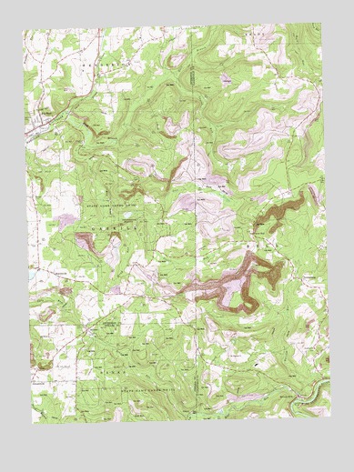
McGees Mills, PA USGS Topographic Map
Click on map above to begin viewing in our Map Viewer.

This topographic map contains these locations and features:
Feature Name Type Latitude Longitude GNIS ID View Map
Bear RunStreamN40.8806°W78.7631°1168919View Map
Big Run Post OfficePost OfficeN40.9689°W78.8704°2773076View Map
Bowers CemeteryCemeteryN40.9471°W78.8712°1170049View Map
BowersvillePopulated PlaceN40.9228°W78.8642°1170056View Map
Bucheit School (historical)SchoolN40.9920°W78.8506°1201152View Map
Clover DamDamN40.9401°W78.8331°1195169View Map
Clover RunStreamN40.9637°W78.8495°1172031View Map
Clover RunPopulated PlaceN40.9340°W78.7800°1203289View Map
Davis SchoolSchoolN40.9145°W78.8261°1201149View Map
East Branch Mahoning CreekStreamN40.9740°W78.8561°1173753View Map
FloraPopulated PlaceN40.8923°W78.8717°1203598View Map
Henderson SchoolSchoolN40.9851°W78.8675°1201151View Map
HillmanPopulated PlaceN40.9048°W78.8500°1203811View Map
Junction Bear Run Branch StationLocaleN40.8792°W78.7948°1213034View Map
Keal RunPopulated PlaceN40.8770°W78.8323°1205058View Map
Laurel RunStreamN40.9856°W78.8098°1178988View Map
Lost RunStreamN40.9392°W78.8211°1179976View Map
Lower Bucheit SchoolSchoolN40.9995°W78.8425°1201147View Map
McClure CemeteryCemeteryN40.9712°W78.8746°1180639View Map
McGees MillsPopulated PlaceN40.8817°W78.7625°1180714View Map
McGees StationLocaleN40.8826°W78.7639°1212998View Map
Mount Pleasant ChurchChurchN40.8953°W78.7914°1181819View Map
NewtonburgPopulated PlaceN40.9187°W78.7606°1182419View Map
Otterbein ChurchChurchN40.8967°W78.7559°1183089View Map
Pleasantville SchoolSchoolN40.8951°W78.8648°1201148View Map
Punxsutawney ReservoirReservoirN40.9405°W78.8323°1184495View Map
Schlimmer SchoolSchoolN40.9917°W78.8264°1201153View Map
SidneyPopulated PlaceN40.8773°W78.8092°1204650View Map
South Branch Bear RunStreamN40.8765°W78.8086°1193396View Map
State Game Lands Number 174ParkN40.8834°W78.8264°1193439View Map
State Game Lands Number 195ParkN40.9470°W78.8439°1188480View Map
Stony RunStreamN40.9412°W78.8295°1188793View Map
Stump CreekStreamN40.9740°W78.8561°1188903View Map
Township of BellCivilN40.9147°W78.7511°1216223View Map
Township of GaskillCivilN40.9387°W78.8493°1216560View Map
Wainwright SchoolSchoolN40.9476°W78.8739°1201150View Map
Whisky RunStreamN40.8848°W78.7550°1191238View Map

Note: Coordinates in the location and feature list above are referenced to NAD83 datum.


Copyright (C) 2008-2024 Ryan Niemi / Sunset Dynamics ... All Rights Reserved