TopoQuest Logo
Do you find TopoQuest useful?
Help keep TopoQuest running and adding new maps/features by donating!
Bitcoin:  19c7KJd3qBynnjoSw5npx9KScwjBe4ifkT
Litecoin:  LXs6TkuXGGXo1vDsWCkWVdjQX94eUKd6ui
Home View Maps Find Maps Find Places Resources & Links


Burnside, Pennsylvania Topographic Map

USGS Map Title: Burnside, PA
USGS Map MRC: 40078G7
DRG (GeoTIFF) Download: o40078g7.tif


Neighboring USGS Topographic Map Quads:


  Punxsutawney, PA  
40078H8
 

  McGees Mills, PA  
40078H7
 

  Mahaffey, PA  
40078H6
 

  Rochester Mills, PA  
40078G8
 

  Burnside, PA  
40078G7
 

  Westover, PA  
40078G6
 

  Commodore, PA  
40078F8
 

  Barnesboro, PA  
40078F7
 

  Hastings, PA  
40078F6


Map MRC Location:

N41°
W79°
N41°
W78°
H8 H7 H6 H5 H4 H3 H2 H1
G8 G7 G6 G5 G4 G3 G2 G1
F8 F7 F6 F5 F4 F3 F2 F1
E8 E7 E6 E5 E4 E3 E2 E1
D8 D7 D6 D5 D4 D3 D2 D1
C8 C7 C6 C5 C4 C3 C2 C1
B8 B7 B6 B5 B4 B3 B2 B1
A8 A7 A6 A5 A4 A3 A2 A1
N40°
W79°
N40°
W78°

Burnside, PA USGS 1:24K Topographic Map Preview:
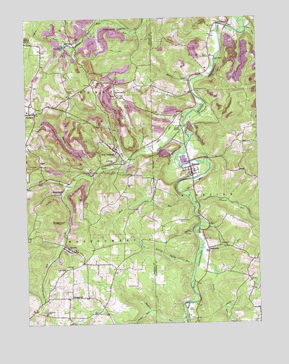
Burnside, PA USGS Topographic Map
Click on map above to begin viewing in our Map Viewer.

This topographic map contains these locations and features:
Feature Name Type Latitude Longitude GNIS ID View Map
ArcadiaPopulated PlaceN40.7812°W78.8525°1192078View Map
Arcadia Post OfficePost OfficeN40.7818°W78.8546°2779894View Map
Beaver RunStreamN40.7806°W78.7800°1192108View Map
Bennett CemeteryCemeteryN40.8064°W78.8206°1192122View Map
Boiling Spring RunStreamN40.7745°W78.7845°1192175View Map
Borough of BurnsideCivilN40.8133°W78.7919°1215094View Map
Borough of Glen CampbellCivilN40.8197°W78.8296°1215288View Map
BowdertownPopulated PlaceN40.7609°W78.8478°1192180View Map
Brady RunStreamN40.8170°W78.8181°1192182View Map
BurnsidePopulated PlaceN40.8128°W78.7856°1192221View Map
Chetremon Golf CourseLocaleN40.7559°W78.7870°1205785View Map
Crossroads School (historical)SchoolN40.8437°W78.8506°1201164View Map
CushLocaleN40.8517°W78.7831°1206871View Map
Cush CreekPopulated PlaceN40.7717°W78.8553°1192324View Map
Cush CreekStreamN40.8306°W78.7892°1192325View Map
Cush Creek JunctionLocaleN40.8348°W78.7936°1213032View Map
Cush Creek SchoolSchoolN40.8317°W78.7920°1201168View Map
Deer RunStreamN40.8703°W78.7550°1192342View Map
Dowler JunctionPopulated PlaceN40.8284°W78.7911°1205038View Map
Elk Lick RunStreamN40.8387°W78.7775°1201953View Map
Elklick School (historical)SchoolN40.8209°W78.7581°1201166View Map
Glen CampbellPopulated PlaceN40.8209°W78.8270°1192521View Map
Glen Campbell Fire TowerTowerN40.8448°W78.8489°1212081View Map
Glen Campbell Post OfficePost OfficeN40.8208°W78.8272°2779940View Map
Glen Campbell Volunteer Fire Department - Station 170BuildingN40.8207°W78.8269°2645634View Map
HooverhurstPopulated PlaceN40.8048°W78.8550°1192631View Map
Horton RunStreamN40.8134°W78.8356°1192635View Map
LochvalePopulated PlaceN40.8651°W78.8489°1205061View Map
LoganPopulated PlaceN40.8167°W78.8675°1205062View Map
Martin RunStreamN40.8492°W78.7856°1192898View Map
Mount AirieLocaleN40.8592°W78.7689°1201169View Map
North RunStreamN40.8687°W78.7581°1193048View Map
Patchin RunStreamN40.7820°W78.7798°1193090View Map
PatchinvillePopulated PlaceN40.7806°W78.7767°1193091View Map
Pine Grove ChurchChurchN40.7731°W78.8500°1193127View Map
Pine Grove SchoolSchoolN40.8492°W78.8181°1201165View Map
Powell RunStreamN40.7556°W78.8084°1193160View Map
RaytownLocaleN40.8226°W78.8092°1201167View Map
RidgeLocaleN40.8692°W78.7736°1213033View Map
Rock RunStreamN40.8028°W78.7864°1193204View Map
Rock Run School (historical)SchoolN40.7992°W78.8206°1201162View Map
Rowley School (historical)SchoolN40.8223°W78.8675°1201163View Map
Saint Michaels CemeteryCemeteryN40.8116°W78.8396°1193263View Map
Saint Michaels ChurchChurchN40.8162°W78.8275°1193264View Map
Saints Peter and Paul ChurchChurchN40.8448°W78.8259°1193272View Map
Sawmill RunStreamN40.7984°W78.7828°1193295View Map
Sentry Volunteer Fire Company Station 64BuildingN40.8114°W78.7857°2645300View Map
Shryock RunStreamN40.7534°W78.7892°1193359View Map
SmithvilleLocaleN40.8384°W78.8650°1212100View Map
Sunderland CemeteryCemeteryN40.8462°W78.7824°1193499View Map
Susquehanna ChurchChurchN40.8578°W78.7725°1193502View Map
Thompson CemeteryCemeteryN40.7550°W78.8649°1193532View Map
Township of BanksCivilN40.8611°W78.8551°1216532View Map
Township of BurnsideCivilN40.7819°W78.7515°2086591View Map
Township of MontgomeryCivilN40.7722°W78.8545°1216545View Map
UreyPopulated PlaceN40.8437°W78.8259°1193588View Map
Urey CemeteryCemeteryN40.8477°W78.8344°1193589View Map
West Branch Cush CreekStreamN40.8073°W78.8490°1202631View Map

Note: Coordinates in the location and feature list above are referenced to NAD83 datum.


Copyright (C) 2008-2025 Ryan Niemi / Sunset Dynamics ... All Rights Reserved