TopoQuest Logo
Do you find TopoQuest useful?
Help keep TopoQuest running and adding new maps/features by donating!
Bitcoin:  19c7KJd3qBynnjoSw5npx9KScwjBe4ifkT
Litecoin:  LXs6TkuXGGXo1vDsWCkWVdjQX94eUKd6ui
Home View Maps Find Maps Find Places Resources & Links


Medill, Missouri Topographic Map

USGS Map Title: Medill, MO
USGS Map MRC: 40091D7
DRG (GeoTIFF) Download: o40091d7.tif


Neighboring USGS Topographic Map Quads:


  Mount Sterling, IA  
40091E8
 

  Anson, MO  
40091E7
 

  Croton, IA  
40091E6
 

  Wyaconda, MO  
40091D8
 

  Medill, MO  
40091D7
 

  Kahoka, MO  
40091D6
 

  Colony, MO  
40091C8
 

  Neeper, MO  
40091C7
 

  Saint Patrick, MO  
40091C6


Map MRC Location:

N41°
W92°
N41°
W91°
H8 H7 H6 H5 H4 H3 H2 H1
G8 G7 G6 G5 G4 G3 G2 G1
F8 F7 F6 F5 F4 F3 F2 F1
E8 E7 E6 E5 E4 E3 E2 E1
D8 D7 D6 D5 D4 D3 D2 D1
C8 C7 C6 C5 C4 C3 C2 C1
B8 B7 B6 B5 B4 B3 B2 B1
A8 A7 A6 A5 A4 A3 A2 A1
N40°
W92°
N40°
W91°

Medill, MO USGS 1:24K Topographic Map Preview:
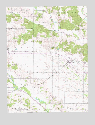
Medill, MO USGS Topographic Map
Click on map above to begin viewing in our Map Viewer.

This topographic map contains these locations and features:
Feature Name Type Latitude Longitude GNIS ID View Map
AshtonPopulated PlaceN40.4461°W91.8077°713445View Map
Ashton ChurchChurchN40.4511°W91.8063°713446View Map
Ashton LakeReservoirN40.4498°W91.7955°763918View Map
Beard SchoolSchoolN40.3778°W91.7877°713829View Map
Boston SchoolSchoolN40.3828°W91.8538°714548View Map
Brotherton Lake DamDamN40.3767°W91.7918°762226View Map
CamaLocaleN40.4048°W91.8332°740108View Map
Carmel ChurchChurchN40.4145°W91.8299°715404View Map
Cemetery ChapelChurchN40.4442°W91.8082°731716View Map
Center ChapelChurchN40.4961°W91.8524°715633View Map
Drew BridgeBridgeN40.4612°W91.7635°731717View Map
Eureka SchoolSchoolN40.4159°W91.8629°735605View Map
Eureka School (historical)SchoolN40.4009°W91.8143°731712View Map
Happy Hill SchoolSchoolN40.4736°W91.8624°719063View Map
Hays School (historical)SchoolN40.4212°W91.8099°731714View Map
Lebanon School (historical)SchoolN40.4075°W91.7582°731715View Map
Linn CreekStreamN40.4723°W91.7918°735695View Map
MedillPopulated PlaceN40.4345°W91.7760°741057View Map
Medill CemeteryCemeteryN40.4436°W91.7760°722194View Map
Medill Census Designated PlaceCensusN40.4319°W91.7786°2587089View Map
Medill Presbyterian ChurchChurchN40.4334°W91.7788°731718View Map
North Linn CreekStreamN40.4781°W91.8291°723479View Map
North Wyaconda RiverStreamN40.4048°W91.8616°459649View Map
Seyb Lake DamDamN40.4517°W91.7952°763917View Map
South Linn CreekStreamN40.4781°W91.8291°726769View Map
South Wyaconda RiverStreamN40.4048°W91.8616°461825View Map
Thompson SchoolSchoolN40.4961°W91.8574°727611View Map
Todd BranchStreamN40.4709°W91.8035°731719View Map
Toops School (historical)SchoolN40.4811°W91.8121°731713View Map
Township of LincolnCivilN40.4287°W91.7681°766497View Map
Woodville Baptist ChurchChurchN40.3781°W91.8552°731720View Map
Woodville ChurchChurchN40.3781°W91.8552°729135View Map
Zimmerman CemeteryCemeteryN40.4517°W91.8735°729230View Map

Note: Coordinates in the location and feature list above are referenced to NAD83 datum.


Copyright (C) 2008-2025 Ryan Niemi / Sunset Dynamics ... All Rights Reserved