TopoQuest Logo
Do you find TopoQuest useful?
Help keep TopoQuest running and adding new maps/features by donating!
Bitcoin:  19c7KJd3qBynnjoSw5npx9KScwjBe4ifkT
Litecoin:  LXs6TkuXGGXo1vDsWCkWVdjQX94eUKd6ui
Home View Maps Find Maps Find Places Resources & Links


Middletown, Missouri Topographic Map

USGS Map Title: Middletown, MO
USGS Map MRC: 39091B4
DRG (GeoTIFF) Download: o39091b4.tif


Neighboring USGS Topographic Map Quads:


  Farber, MO  
39091C5
 

  Vandalia, MO  
39091C4
 

  Curryville, MO  
39091C3
 

  Vandalia Lake, MO  
39091B5
 

  Middletown, MO  
39091B4
 

  New Hartford, MO  
39091B3
 

  Wellsville, MO  
39091A5
 

  Buell, MO  
39091A4
 

  Bellflower North, MO  
39091A3


Map MRC Location:

N40°
W92°
N40°
W91°
H8 H7 H6 H5 H4 H3 H2 H1
G8 G7 G6 G5 G4 G3 G2 G1
F8 F7 F6 F5 F4 F3 F2 F1
E8 E7 E6 E5 E4 E3 E2 E1
D8 D7 D6 D5 D4 D3 D2 D1
C8 C7 C6 C5 C4 C3 C2 C1
B8 B7 B6 B5 B4 B3 B2 B1
A8 A7 A6 A5 A4 A3 A2 A1
N39°
W92°
N39°
W91°

Middletown, MO USGS 1:24K Topographic Map Preview:
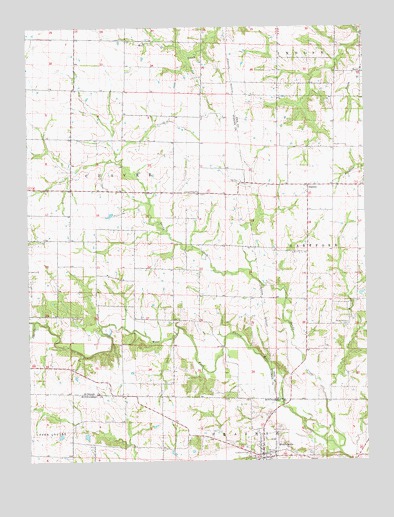
Middletown, MO USGS Topographic Map
Click on map above to begin viewing in our Map Viewer.

This topographic map contains these locations and features:
Feature Name Type Latitude Longitude GNIS ID View Map
Allison Lake DamDamN39.1334°W91.4785°762142View Map
Barber Lake DamDamN39.1784°W91.4818°762149View Map
Bruce Crysdale DamDamN39.1750°W91.3768°761230View Map
Camerer DamDamN39.2050°W91.4168°760583View Map
Camerer LakeReservoirN39.2080°W91.4167°760584View Map
Central Union ChurchChurchN39.2025°W91.4368°715694View Map
Clithero LakeReservoirN39.2267°W91.4085°762152View Map
Clithero LakeReservoirN39.1824°W91.3850°761641View Map
Clithero Lake DamDamN39.2267°W91.4085°762151View Map
Clithero Lake DamDamN39.1800°W91.3852°761640View Map
Crow School (historical)SchoolN39.1892°W91.4896°742545View Map
Culwell School (historical)SchoolN39.2092°W91.4368°742542View Map
Drysdale LakeReservoirN39.1750°W91.3768°761231View Map
Ehrlick Dam SouthDamN39.1284°W91.4352°762143View Map
Ehrlick LakeReservoirN39.1351°W91.4303°761643View Map
Ehrlick Lake DamDamN39.1334°W91.4285°761642View Map
EstesPopulated PlaceN39.2367°W91.3763°740837View Map
Estes School (historical)SchoolN39.2369°W91.3766°744253View Map
Fairmount CemeteryCemeteryN39.1267°W91.4196°717742View Map
GazettePopulated PlaceN39.2045°W91.3960°718375View Map
Hall School (historical)SchoolN39.1725°W91.4377°742544View Map
Heim Lake DamDamN39.1550°W91.4118°762144View Map
Heim Lake DamDamN39.1800°W91.4218°762147View Map
Johns BranchStreamN39.1456°W91.3918°720346View Map
Lost CreekStreamN39.1653°W91.4982°721585View Map
MiddletownPopulated PlaceN39.1270°W91.4140°755560View Map
Middletown Fire Protection DistrictBuildingN39.1261°W91.4144°2621419View Map
Middletown Post OfficePost OfficeN39.1268°W91.4142°2783215View Map
Mount Carmel (historical)LocaleN39.1675°W91.4888°744145View Map
Mount Carmel Post Office (historical)Post OfficeN39.1675°W91.4888°759508View Map
Payne CemeteryCemeteryN39.1664°W91.4843°724118View Map
Ray Lake DamDamN39.2034°W91.4852°762150View Map
Rudd School (historical)SchoolN39.1639°W91.3815°742546View Map
Rudd School CemeteryCemeteryN39.1645°W91.3824°725653View Map
Sandy CreekStreamN39.1284°W91.3863°726035View Map
Town of MiddletownCivilN39.1287°W91.4138°2396760View Map
Trower School (historical)SchoolN39.2042°W91.3765°742543View Map
Wendell L Heim LakeReservoirN39.1800°W91.4218°762148View Map
Wendells LakeReservoirN39.1817°W91.4035°762146View Map
Wendells Lake DamDamN39.1817°W91.4035°762145View Map
Whiteside School (historical)SchoolN39.1389°W91.4515°742547View Map

Note: Coordinates in the location and feature list above are referenced to NAD83 datum.


Copyright (C) 2008-2025 Ryan Niemi / Sunset Dynamics ... All Rights Reserved