TopoQuest Logo
Do you find TopoQuest useful?
Help keep TopoQuest running and adding new maps/features by donating!
Bitcoin:  19c7KJd3qBynnjoSw5npx9KScwjBe4ifkT
Litecoin:  LXs6TkuXGGXo1vDsWCkWVdjQX94eUKd6ui
Home View Maps Find Maps Find Places Resources & Links


Montrose East, Pennsylvania Topographic Map

USGS Map Title: Montrose East, PA
USGS Map MRC: 41075G7
DRG (GeoTIFF) Download: o41075g7.tif


Neighboring USGS Topographic Map Quads:


  Laurel Lake, PA  
41075H8
 

  Franklin Forks, PA  
41075H7
 

  Great Bend, PA  
41075H6
 

  Montrose West, PA  
41075G8
 

  Montrose East, PA  
41075G7
 

  Harford, PA  
41075G6
 

  Springville, PA  
41075F8
 

  Hop Bottom, PA  
41075F7
 

  Lenoxville, PA  
41075F6


Map MRC Location:

N42°
W76°
N42°
W75°
H8 H7 H6 H5 H4 H3 H2 H1
G8 G7 G6 G5 G4 G3 G2 G1
F8 F7 F6 F5 F4 F3 F2 F1
E8 E7 E6 E5 E4 E3 E2 E1
D8 D7 D6 D5 D4 D3 D2 D1
C8 C7 C6 C5 C4 C3 C2 C1
B8 B7 B6 B5 B4 B3 B2 B1
A8 A7 A6 A5 A4 A3 A2 A1
N41°
W76°
N41°
W75°

Montrose East, PA USGS 1:24K Topographic Map Preview:
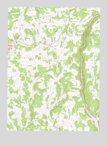
Montrose East, PA USGS Topographic Map
Click on map above to begin viewing in our Map Viewer.

This topographic map contains these locations and features:
Feature Name Type Latitude Longitude GNIS ID View Map
AlfordPopulated PlaceN41.8067°W75.7746°1202962View Map
Beaver Meadow PondLakeN41.7919°W75.7550°1169019View Map
Birchard HillSummitN41.8473°W75.8449°1169652View Map
Brewster PondReservoirN41.8035°W75.8674°1170217View Map
Brewster Pond DamDamN41.8017°W75.8663°1195791View Map
BrooklynPopulated PlaceN41.7512°W75.8069°1170330View Map
Brooklyn Post OfficePost OfficeN41.7531°W75.8073°2780024View Map
East Branch Martins CreekStreamN41.7623°W75.7557°1173754View Map
East Bridgewater ChurchChurchN41.8198°W75.8077°1173783View Map
East Bridgewater SchoolSchoolN41.8190°W75.8071°1197628View Map
Elbow PondLakeN41.8731°W75.7913°1174073View Map
Ely LakeLakeN41.7605°W75.8354°1174198View Map
Gardner SchoolSchoolN41.8431°W75.8030°1197627View Map
Heart LakeLakeN41.8487°W75.7913°1176728View Map
Heart LakePopulated PlaceN41.8523°W75.7941°1176729View Map
Johnson PondLakeN41.7873°W75.8712°1178118View Map
Jones LakeLakeN41.7672°W75.7878°1178148View Map
KingsleyPopulated PlaceN41.7598°W75.7521°1178505View Map
Kingsley Post OfficePost OfficeN41.7594°W75.7520°2768347View Map
Lake ChrisannLakeN41.8390°W75.7994°1171802View Map
Lake MontroseReservoirN41.8418°W75.8567°1181486View Map
Lake Montrose DamDamN41.8451°W75.8596°1195814View Map
Lake Montrose PlazaAreaN41.8379°W75.8521°1214551View Map
Lake RayleanReservoirN41.8507°W75.8056°1184723View Map
Lathrop Street Elementary SchoolSchoolN41.8384°W75.8663°1207231View Map
Loomis LakeReservoirN41.8390°W75.7994°1195812View Map
Loomis Lake DamDamN41.8434°W75.7980°1195813View Map
Lower Alford DamDamN41.8067°W75.7730°1195798View Map
Lower Alford PondReservoirN41.8181°W75.7738°1180006View Map
Lower LakeReservoirN41.8048°W75.7581°1180020View Map
Lower Lake DamDamN41.8034°W75.7630°1195795View Map
McKinney PondLakeN41.7678°W75.7962°1180760View Map
Middle LakeReservoirN41.8145°W75.7587°1181036View Map
Middle Lake DamDamN41.8134°W75.7580°1195805View Map
Montrose Area High SchoolSchoolN41.8437°W75.8457°1181483View Map
Montrose Area High School Memorial StadiumParkN41.8415°W75.8355°1214516View Map
Montrose General HospitalHospitalN41.8326°W75.8728°2718010View Map
Montrose Minute Men AmbulanceBuildingN41.8358°W75.8683°2722113View Map
Mott SchoolSchoolN41.8495°W75.8585°1214155View Map
Newton Hill CemeteryCemeteryN41.7984°W75.8260°1182416View Map
North PondLakeN41.7762°W75.8341°1182622View Map
Pa-468 DamDamN41.7551°W75.8063°1195782View Map
Pa-468 ReservoirReservoirN41.7563°W75.8065°1195781View Map
Poplar HillSummitN41.8429°W75.7607°1184254View Map
Post PondReservoirN41.8279°W75.8614°1184316View Map
Post Pond DamDamN41.8284°W75.8630°1195809View Map
Reynolds PondLakeN41.8269°W75.8145°1184970View Map
Rosengrants CemeteryCemeteryN41.7734°W75.8480°1193215View Map
Stone PondLakeN41.7722°W75.8740°1188730View Map
Susquehanna CountyCivilN41.8213°W75.8007°1213688View Map
TiffanyPopulated PlaceN41.8370°W75.8207°1189565View Map
Tiffany PondLakeN41.7622°W75.7737°1189567View Map
Township of BridgewaterCivilN41.8335°W75.8253°1217078View Map
Township of BrooklynCivilN41.7598°W75.8009°1217079View Map
Upper Alford PondLakeN41.8381°W75.7699°1190222View Map
Upper LakeLakeN41.8257°W75.7545°1190236View Map
Warner DamDamN41.8534°W75.8463°1195819View Map
Warner PondReservoirN41.8534°W75.8463°1195820View Map
Warriner PondLakeN41.8517°W75.8426°1190602View Map
Watrous CornersLocaleN41.8051°W75.8407°1190688View Map
Williams CornerPopulated PlaceN41.8590°W75.8313°1204954View Map
Williams PondReservoirN41.8573°W75.8318°1191466View Map
Williams Pond CemeteryCemeteryN41.8598°W75.8185°1191468View Map
Williams Pond DamDamN41.8601°W75.8346°1195824View Map
WPEL-AM (Montrose)TowerN41.8545°W75.8635°1200516View Map
WPEL-FM (Montrose)TowerN41.8545°W75.8635°1200323View Map
Zlotucha PondLakeN41.8401°W75.8296°1192027View Map

Note: Coordinates in the location and feature list above are referenced to NAD83 datum.


Copyright (C) 2008-2024 Ryan Niemi / Sunset Dynamics ... All Rights Reserved