TopoQuest Logo
Do you find TopoQuest useful?
Help keep TopoQuest running and adding new maps/features by donating!
Bitcoin:  19c7KJd3qBynnjoSw5npx9KScwjBe4ifkT
Litecoin:  LXs6TkuXGGXo1vDsWCkWVdjQX94eUKd6ui
Home View Maps Find Maps Find Places Resources & Links


Newton, Utah Topographic Map

USGS Map Title: Newton, UT
USGS Map MRC: 41111G8
DRG (GeoTIFF) Download: o41111g8.tif


Neighboring USGS Topographic Map Quads:


  Clarkston, UT  
41112H1
 

  Trenton, UT  
41111H8
 

  Richmond, UT  
41111H7
 

  Cutler Dam, UT  
41112G1
 

  Newton, UT  
41111G8
 

  Smithfield, UT  
41111G7
 

  Honeyville, UT  
41112F1
 

  Wellsville, UT  
41111F8
 

  Logan, UT  
41111F7


Map MRC Location:

N42°
W112°
N42°
W111°
H8 H7 H6 H5 H4 H3 H2 H1
G8 G7 G6 G5 G4 G3 G2 G1
F8 F7 F6 F5 F4 F3 F2 F1
E8 E7 E6 E5 E4 E3 E2 E1
D8 D7 D6 D5 D4 D3 D2 D1
C8 C7 C6 C5 C4 C3 C2 C1
B8 B7 B6 B5 B4 B3 B2 B1
A8 A7 A6 A5 A4 A3 A2 A1
N41°
W112°
N41°
W111°

Newton, UT USGS 1:24K Topographic Map Preview:
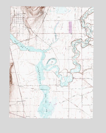
Newton, UT USGS Topographic Map
Click on map above to begin viewing in our Map Viewer.

This topographic map contains these locations and features:
Feature Name Type Latitude Longitude GNIS ID View Map
AmalgaPopulated PlaceN41.8610°W111.8958°1437485View Map
Ballard JunctionPopulated PlaceN41.7852°W111.9869°1437495View Map
BensonPopulated PlaceN41.7874°W111.9302°1425433View Map
Benson MarinaLocaleN41.7866°W111.9552°1455182View Map
Benson SchoolSchoolN41.7958°W111.9049°1425436View Map
Blue Spring CreekStreamN41.7647°W111.9372°1438958View Map
Cache ValleyValleyN41.8166°W111.9341°1451135View Map
Clay SloughStreamN41.8249°W111.9508°1426693View Map
Cutler ReservoirReservoirN41.8321°W111.9879°1440215View Map
Fourmile CreekStreamN41.7697°W111.9513°1441193View Map
Hopkins SloughStreamN41.8024°W111.8980°1441850View Map
Horseshoe BendBendN41.8160°W111.9386°1428883View Map
NewtonPopulated PlaceN41.8627°W111.9908°1430705View Map
Newton CreekStreamN41.8308°W111.9736°1430707View Map
Newton Fire DepartmentBuildingN41.8613°W111.9892°2627182View Map
Newton Post OfficePost OfficeN41.8626°W111.9882°2769032View Map
North Logan Benson CanalCanalN41.7949°W111.8811°1443957View Map
Peter Census Designated PlaceCensusN41.7716°W111.9859°2409057View Map
PetersboroPopulated PlaceN41.7691°W111.9816°1437657View Map
Quigley CrossingPopulated PlaceN41.8669°W111.9811°1437661View Map
RiversidePopulated PlaceN41.7977°W111.9308°1436234View Map
Smithfield DivisionCivilN41.8432°W111.9227°1939416View Map
Smithfield Fire and Emergency Medical Services Station 43BuildingN41.8524°W111.8934°2627372View Map
South Logan Benson CanalCanalN41.7855°W111.8780°1445901View Map
Summit CreekStreamN41.8335°W111.8874°1446239View Map
Swift SloughGutN41.7713°W111.9108°1433143View Map
The BarrensAreaN41.8624°W111.9194°1433257View Map
The Church of Jesus Christ of Latter Day SaintsChurchN41.8621°W111.9911°1437024View Map
The Church of Jesus Christ of Latter Day SaintsChurchN41.8516°W111.8944°1436801View Map
The Church of Jesus Christ of Latter Day SaintsChurchN41.7949°W111.9055°1436817View Map
The IslandIslandN41.8122°W111.9372°1433347View Map
The PointSummitN41.8077°W111.9994°1433402View Map
Threemile CreekStreamN41.7522°W111.9533°1446581View Map
Town of AmalgaCivilN41.8565°W111.8974°2412359View Map
Town of NewtonCivilN41.8612°W111.9907°2413048View Map

Note: Coordinates in the location and feature list above are referenced to NAD83 datum.


Copyright (C) 2008-2025 Ryan Niemi / Sunset Dynamics ... All Rights Reserved