TopoQuest Logo
Do you find TopoQuest useful?
Help keep TopoQuest running and adding new maps/features by donating!
Bitcoin:  19c7KJd3qBynnjoSw5npx9KScwjBe4ifkT
Litecoin:  LXs6TkuXGGXo1vDsWCkWVdjQX94eUKd6ui
Home View Maps Find Maps Find Places Resources & Links


Sudbury, Vermont Topographic Map

USGS Map Title: Sudbury, VT
USGS Map MRC: 43073G2
DRG (GeoTIFF) Download: o43073g2.tif


Neighboring USGS Topographic Map Quads:


  Bridport, VT  
43073H3
 

  Cornwall, VT  
43073H2
 

  East Middlebury, VT  
43073H1
 

  Orwell, VT  
43073G3
 

  Sudbury, VT  
43073G2
 

  Brandon, VT  
43073G1
 

  Benson, VT  
43073F3
 

  Bomoseen, VT  
43073F2
 

  Proctor, VT  
43073F1


Map MRC Location:

N44°
W74°
N44°
W73°
H8 H7 H6 H5 H4 H3 H2 H1
G8 G7 G6 G5 G4 G3 G2 G1
F8 F7 F6 F5 F4 F3 F2 F1
E8 E7 E6 E5 E4 E3 E2 E1
D8 D7 D6 D5 D4 D3 D2 D1
C8 C7 C6 C5 C4 C3 C2 C1
B8 B7 B6 B5 B4 B3 B2 B1
A8 A7 A6 A5 A4 A3 A2 A1
N43°
W74°
N43°
W73°

Sudbury, VT USGS 1:24K Topographic Map Preview:
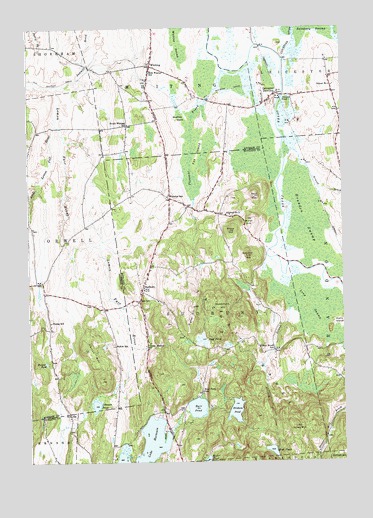
Sudbury, VT USGS Topographic Map
Click on map above to begin viewing in our Map Viewer.

This topographic map contains these locations and features:
Feature Name Type Latitude Longitude GNIS ID View Map
Andys CampLocaleN43.7598°W73.1954°1921730View Map
Arnold BrookStreamN43.8340°W73.1384°1460532View Map
Bald HillSummitN43.8265°W73.1596°1456218View Map
Beartrap IslandIslandN43.8495°W73.1862°1456331View Map
Brandon SwampSwampN43.8192°W73.1398°1456555View Map
Brandon Swamp Wildlife Management AreaParkN43.8328°W73.1509°1921766View Map
Burr PondReservoirN43.7655°W73.1834°1456679View Map
Burr Pond DamDamN43.7653°W73.1832°1766471View Map
Burr Pond SchoolSchoolN43.7701°W73.1809°1456680View Map
Camp Sky BirdLocaleN43.7612°W73.1865°1921781View Map
Choates CemeteryCemeteryN43.7688°W73.2385°1918069View Map
Crown Point Road MonumentParkN43.7956°W73.1579°1921831View Map
Crown Point Road Monument CemeteryCemeteryN43.8270°W73.2087°1921832View Map
Felton HillSummitN43.7823°W73.2282°1457420View Map
Felton SchoolSchoolN43.7834°W73.2157°1457421View Map
Fortier PondLakeN43.7785°W73.2432°1457474View Map
Fox IslandIslandN43.8384°W73.1818°1457486View Map
G F Emmons CemeteryCemeteryN43.8628°W73.2017°1918106View Map
High PondLakeN43.7532°W73.1539°1457818View Map
Hill CemeteryCemeteryN43.8028°W73.2032°1921919View Map
Hill SchoolSchoolN43.7967°W73.2057°1457830View Map
Hinkum PondLakeN43.7647°W73.1680°1457842View Map
Huff PondLakeN43.7851°W73.1813°1457932View Map
Hyde ManorPopulated PlaceN43.7834°W73.2026°1457954View Map
Johnson PondLakeN43.7664°W73.2236°1458024View Map
Lake HortoniaReservoirN43.7512°W73.2069°1457900View Map
Leicester JunctionPopulated PlaceN43.8559°W73.1504°1458191View Map
Leicester RiverStreamN43.8659°W73.1476°1461065View Map
Little Lemon Fair RiverStreamN43.8470°W73.2382°1458244View Map
Long SwampSwampN43.7951°W73.1384°1458280View Map
Miller HillSummitN43.8201°W73.1623°1458477View Map
Old South CemeteryCemeteryN43.8436°W73.1967°1918191View Map
Pleasant BrookStreamN43.8628°W73.1712°1458998View Map
Richville Wildlife Management AreaParkN43.8503°W73.2390°1918210View Map
Sawmill BrookStreamN43.8581°W73.2396°1459384View Map
School Number 1SchoolN43.8215°W73.1709°1459402View Map
School Number 4SchoolN43.8581°W73.1284°1459413View Map
Shoreham Covered Railroad BridgeBridgeN43.8637°W73.2246°1918241View Map
Signal HillSummitN43.7945°W73.1843°1459505View Map
South Whiting SchoolSchoolN43.8467°W73.2101°1459622View Map
Spooner HillSummitN43.8092°W73.1626°1459642View Map
Stiles MountainSummitN43.7601°W73.1446°1459715View Map
Stony HillSummitN43.8165°W73.1696°1459739View Map
SudburyPopulated PlaceN43.7992°W73.2046°1459766View Map
Sudbury Congregational ChurchChurchN43.7995°W73.2037°1922139View Map
Sudbury Country SchoolSchoolN43.8222°W73.1859°2427560View Map
Sudbury Town HallBuildingN43.7990°W73.2032°1922141View Map
Swamp PondLakeN43.8542°W73.1480°1459799View Map
Town of SudburyCivilN43.7911°W73.1800°1462222View Map
Town of WhitingCivilN43.8720°W73.1997°1462260View Map
Village CemeteryCemeteryN43.8646°W73.2016°1918972View Map
Wallace CemeteryCemeteryN43.8249°W73.1882°1922179View Map
Warrior LakesLakeN43.7626°W73.1996°1460354View Map
Webster SchoolSchoolN43.8267°W73.1937°1460092View Map
WhitingPopulated PlaceN43.8640°W73.2004°1460232View Map
Whiting Community ChurchChurchN43.8648°W73.2009°1918275View Map
Whiting Post OfficePost OfficeN43.8639°W73.2003°1918277View Map
Whiting Village SchoolSchoolN43.8582°W73.2015°1459446View Map
Whiting Volunteer Fire DepartmentBuildingN43.8589°W73.2016°2121360View Map
Willow BrookStreamN43.8087°W73.1532°1460284View Map
Willow Brook CemeteryCemeteryN43.7811°W73.1524°1922210View Map
Willow Brook SchoolSchoolN43.7823°W73.1526°1460286View Map
Woodchuck HillSummitN43.7959°W73.1734°1460312View Map
Young SchoolSchoolN43.7903°W73.2412°1460341View Map

Note: Coordinates in the location and feature list above are referenced to NAD83 datum.


Copyright (C) 2008-2024 Ryan Niemi / Sunset Dynamics ... All Rights Reserved