TopoQuest Logo
Do you find TopoQuest useful?
Help keep TopoQuest running and adding new maps/features by donating!
Bitcoin:  19c7KJd3qBynnjoSw5npx9KScwjBe4ifkT
Litecoin:  LXs6TkuXGGXo1vDsWCkWVdjQX94eUKd6ui
Home View Maps Find Maps Find Places Resources & Links


Portland Mills, Pennsylvania Topographic Map

USGS Map Title: Portland Mills, PA
USGS Map MRC: 41078D7
DRG (GeoTIFF) Download: o41078d7.tif


Neighboring USGS Topographic Map Quads:


  Russell City, PA  
41078E8
 

  James City, PA  
41078E7
 

  Wilcox, PA  
41078E6
 

  Hallton, PA  
41078D8
 

  Portland Mills, PA  
41078D7
 

  Ridgway, PA  
41078D6
 

  Munderf, PA  
41078C8
 

  Carman, PA  
41078C7
 

  Brandy Camp, PA  
41078C6


Map MRC Location:

N42°
W79°
N42°
W78°
H8 H7 H6 H5 H4 H3 H2 H1
G8 G7 G6 G5 G4 G3 G2 G1
F8 F7 F6 F5 F4 F3 F2 F1
E8 E7 E6 E5 E4 E3 E2 E1
D8 D7 D6 D5 D4 D3 D2 D1
C8 C7 C6 C5 C4 C3 C2 C1
B8 B7 B6 B5 B4 B3 B2 B1
A8 A7 A6 A5 A4 A3 A2 A1
N41°
W79°
N41°
W78°

Portland Mills, PA USGS 1:24K Topographic Map Preview:
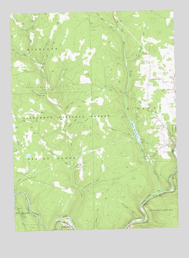
Portland Mills, PA USGS Topographic Map
Click on map above to begin viewing in our Map Viewer.

This topographic map contains these locations and features:
Feature Name Type Latitude Longitude GNIS ID View Map
Bear CreekLocaleN41.3992°W78.8220°1207126View Map
Bear CreekStreamN41.3815°W78.8314°1209401View Map
Bear Creek Gas FieldOilfieldN41.4598°W78.8436°1198368View Map
Bear Creek Picnic AreaAreaN41.4712°W78.8528°1198369View Map
Big Mill CreekStreamN41.3956°W78.7628°1209421View Map
Bloody RunStreamN41.4715°W78.8523°1198453View Map
Central TrailTrailN41.4953°W78.7581°1200835View Map
Connerville RunStreamN41.3803°W78.7831°1198596View Map
Crooked RunStreamN41.4101°W78.8289°1198621View Map
Davidson RunStreamN41.4117°W78.8292°1198640View Map
Island RunStreamN41.3973°W78.7525°1198930View Map
Italian Shanty RunStreamN41.4542°W78.8478°1198932View Map
Kings Airfield (historical)AirportN41.4709°W78.7706°1200836View Map
Little Bear CreekStreamN41.3978°W78.8214°1199046View Map
Little Otter CreekStreamN41.4431°W78.8364°1199056View Map
Mill CreekLocaleN41.3959°W78.7639°1200765View Map
North Branch Island RunStreamN41.3978°W78.7511°1199920View Map
Norton DamDamN41.4240°W78.7791°1199237View Map
Ott CemeteryCemeteryN41.4611°W78.7641°1199259View Map
Ott SchoolSchoolN41.4609°W78.7600°1200837View Map
Otter RunStreamN41.4470°W78.8398°1210469View Map
Pole Road RunStreamN41.4367°W78.8334°1199325View Map
Portland MillsPopulated PlaceN41.3781°W78.8342°1199333View Map
Red Lick RunStreamN41.4751°W78.8581°1209920View Map
Red Mill RunStreamN41.4909°W78.7911°1209921View Map
Ridgeway Forest Service StationLocaleN41.4478°W78.7506°1210470View Map
Ridgway ReservoirReservoirN41.4354°W78.7838°1199378View Map
Rocky RunStreamN41.4701°W78.7861°1199409View Map
Round Top Fire TowerTowerN41.4642°W78.8167°1200766View Map
Shanty RunStreamN41.4323°W78.8342°1199514View Map
South Branch Island RunStreamN41.3973°W78.7511°1199563View Map
Standing Stone RunStreamN41.4478°W78.8400°1212789View Map
Twin Lick RunStreamN41.4901°W78.8611°1210067View Map
Windfall RunStreamN41.4278°W78.7803°1199799View Map

Note: Coordinates in the location and feature list above are referenced to NAD83 datum.


Copyright (C) 2008-2025 Ryan Niemi / Sunset Dynamics ... All Rights Reserved