TopoQuest Logo
Do you find TopoQuest useful?
Help keep TopoQuest running and adding new maps/features by donating!
Bitcoin:  19c7KJd3qBynnjoSw5npx9KScwjBe4ifkT
Litecoin:  LXs6TkuXGGXo1vDsWCkWVdjQX94eUKd6ui
Home View Maps Find Maps Find Places Resources & Links


Munderf, Pennsylvania Topographic Map

USGS Map Title: Munderf, PA
USGS Map MRC: 41078C8
DRG (GeoTIFF) Download: o41078c8.tif


Neighboring USGS Topographic Map Quads:


  Marienville East, PA  
41079D1
 

  Hallton, PA  
41078D8
 

  Portland Mills, PA  
41078D7
 

  Sigel, PA  
41079C1
 

  Munderf, PA  
41078C8
 

  Carman, PA  
41078C7
 

  Brookville, PA  
41079B1
 

  Hazen, PA  
41078B8
 

  Falls Creek, PA  
41078B7


Map MRC Location:

N42°
W79°
N42°
W78°
H8 H7 H6 H5 H4 H3 H2 H1
G8 G7 G6 G5 G4 G3 G2 G1
F8 F7 F6 F5 F4 F3 F2 F1
E8 E7 E6 E5 E4 E3 E2 E1
D8 D7 D6 D5 D4 D3 D2 D1
C8 C7 C6 C5 C4 C3 C2 C1
B8 B7 B6 B5 B4 B3 B2 B1
A8 A7 A6 A5 A4 A3 A2 A1
N41°
W79°
N41°
W78°

Munderf, PA USGS 1:24K Topographic Map Preview:
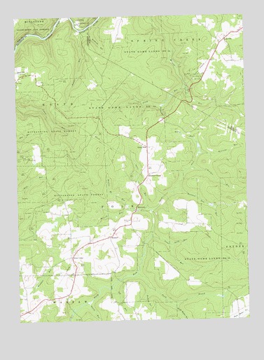
Munderf, PA USGS Topographic Map
Click on map above to begin viewing in our Map Viewer.

This topographic map contains these locations and features:
Feature Name Type Latitude Longitude GNIS ID View Map
Acy RunStreamN41.2640°W78.9486°1209381View Map
Bearpen RunStreamN41.3126°W78.9045°1209405View Map
Beaver Meadow RunStreamN41.2559°W78.9148°1209407View Map
BlowtownPopulated PlaceN41.2959°W78.9348°1209431View Map
Bushley RunStreamN41.2640°W78.9284°1209465View Map
Callen Run TrailTrailN41.3317°W78.9795°1210360View Map
Chicken RunStreamN41.3381°W78.9192°1209499View Map
Clyde RunStreamN41.3731°W78.9761°1209511View Map
Daugherty RunStreamN41.3698°W78.9606°1209547View Map
Davis RunStreamN41.2959°W78.9281°1209548View Map
Dixon CornerPopulated PlaceN41.2762°W78.9703°1209562View Map
Dutch HillSummitN41.3526°W78.9989°1209577View Map
Dutch Hill SchoolSchoolN41.3523°W78.9981°1210298View Map
Green BriarPopulated PlaceN41.3215°W78.9278°1209641View Map
Hays Lookout TowerTowerN41.3173°W78.9942°1210299View Map
Hetrick RunStreamN41.2953°W78.9267°1209671View Map
Lake CityPopulated PlaceN41.3648°W78.8856°1209741View Map
Lake City SchoolSchoolN41.3651°W78.8853°1210297View Map
Lucas RunStreamN41.2845°W78.9264°1209785View Map
Mammy Hi RunStreamN41.2962°W78.9392°1209792View Map
Manners Dam RunStreamN41.3045°W78.9123°1209793View Map
McFadden TrailTrailN41.2951°W78.9570°1210301View Map
Muddy RunStreamN41.3190°W78.8998°1209842View Map
MunderfPopulated PlaceN41.2845°W78.9495°1209844View Map
Munderf CemeteryCemeteryN41.2911°W78.9416°1209845View Map
Munderf TrailTrailN41.3084°W78.9534°1210361View Map
Painter RunStreamN41.3717°W78.9670°1210199View Map
Raught RunStreamN41.3695°W78.9639°1209916View Map
Schoffner CornerPopulated PlaceN41.3098°W78.9278°1209958View Map
Seneca RunStreamN41.2573°W78.9620°1209966View Map
South Branch North Fork Redbank CreekStreamN41.2692°W78.9356°1214101View Map
State Game Lands Number 54ParkN41.2762°W78.8981°1210009View Map
Stony RunStreamN41.3459°W78.9075°1210019View Map
Swede RunStreamN41.2809°W78.9161°1210026View Map
Township of PolkCivilN41.2952°W78.9397°1216568View Map
Truman TrailTrailN41.3006°W78.9581°1210300View Map
Williams RunStreamN41.3187°W78.8998°1210230View Map

Note: Coordinates in the location and feature list above are referenced to NAD83 datum.


Copyright (C) 2008-2024 Ryan Niemi / Sunset Dynamics ... All Rights Reserved