TopoQuest Logo
Do you find TopoQuest useful?
Help keep TopoQuest running and adding new maps/features by donating!
Bitcoin:  19c7KJd3qBynnjoSw5npx9KScwjBe4ifkT
Litecoin:  LXs6TkuXGGXo1vDsWCkWVdjQX94eUKd6ui
Home View Maps Find Maps Find Places Resources & Links


Carman, Pennsylvania Topographic Map

USGS Map Title: Carman, PA
USGS Map MRC: 41078C7
DRG (GeoTIFF) Download: o41078c7.tif


Neighboring USGS Topographic Map Quads:


  Hallton, PA  
41078D8
 

  Portland Mills, PA  
41078D7
 

  Ridgway, PA  
41078D6
 

  Munderf, PA  
41078C8
 

  Carman, PA  
41078C7
 

  Brandy Camp, PA  
41078C6
 

  Hazen, PA  
41078B8
 

  Falls Creek, PA  
41078B7
 

  Sabula, PA  
41078B6


Map MRC Location:

N42°
W79°
N42°
W78°
H8 H7 H6 H5 H4 H3 H2 H1
G8 G7 G6 G5 G4 G3 G2 G1
F8 F7 F6 F5 F4 F3 F2 F1
E8 E7 E6 E5 E4 E3 E2 E1
D8 D7 D6 D5 D4 D3 D2 D1
C8 C7 C6 C5 C4 C3 C2 C1
B8 B7 B6 B5 B4 B3 B2 B1
A8 A7 A6 A5 A4 A3 A2 A1
N41°
W79°
N41°
W78°

Carman, PA USGS 1:24K Topographic Map Preview:
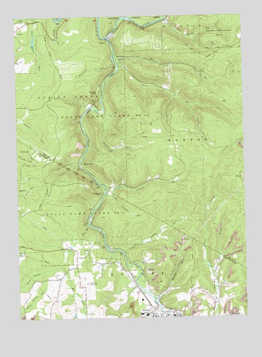
Carman, PA USGS Topographic Map
Click on map above to begin viewing in our Map Viewer.

This topographic map contains these locations and features:
Feature Name Type Latitude Longitude GNIS ID View Map
Baghdad RunStreamN41.2573°W78.7998°1209390View Map
Bearmouth RunStreamN41.3565°W78.8189°1209404View Map
Belmouth RunStreamN41.3556°W78.8184°1209413View Map
Bliss RunStreamN41.2884°W78.8350°1209429View Map
Blue RockCliffN41.3145°W78.8353°1209436View Map
CarmanPopulated PlaceN41.3659°W78.8245°1209481View Map
CCC Camp (historical)LocaleN41.3581°W78.8175°1210296View Map
Coward RunStreamN41.3356°W78.8273°1209534View Map
CroylandPopulated PlaceN41.3576°W78.8170°1209538View Map
Dog Hollow RunStreamN41.3740°W78.7923°1209565View Map
East Branch Walburn RunStreamN41.2681°W78.7675°1209581View Map
Elk Lick BluffCliffN41.3438°W78.8298°1209593View Map
Empire TunnelTunnelN41.3398°W78.8306°1210425View Map
Gillis RunStreamN41.3748°W78.8120°1209630View Map
Indian Rock TrailTrailN41.3456°W78.8164°1210295View Map
Jenkins RunStreamN41.2773°W78.8173°1209708View Map
Laurel RunStreamN41.3562°W78.8173°1209748View Map
Little Toby CreekStreamN41.3665°W78.8236°1209775View Map
Little Vineyard RunStreamN41.3017°W78.8261°1209776View Map
Mahood RunStreamN41.3734°W78.8509°1209791View Map
Saint Tobias CemeteryCemeteryN41.2550°W78.7818°1210424View Map
South Branch Laurel RunStreamN41.3376°W78.7789°1212862View Map
State Game Lands Number 44ParkN41.3367°W78.8167°1210008View Map
TapawingoPopulated PlaceN41.3731°W78.7914°1210423View Map
Township of SnyderCivilN41.2572°W78.8114°1216572View Map
Vineyard PointCliffN41.3017°W78.8300°1210075View Map
Vineyard RunStreamN41.3042°W78.8264°1210076View Map
West Branch Walburn RunStreamN41.2681°W78.7675°1210094View Map

Note: Coordinates in the location and feature list above are referenced to NAD83 datum.


Copyright (C) 2008-2025 Ryan Niemi / Sunset Dynamics ... All Rights Reserved