TopoQuest Logo
Do you find TopoQuest useful?
Help keep TopoQuest running and adding new maps/features by donating!
Bitcoin:  19c7KJd3qBynnjoSw5npx9KScwjBe4ifkT
Litecoin:  LXs6TkuXGGXo1vDsWCkWVdjQX94eUKd6ui
Home View Maps Find Maps Find Places Resources & Links


Progress, Mississippi Topographic Map

USGS Map Title: Progress, MS
USGS Map MRC: 31090A3
DRG (GeoTIFF) Download: o31090a3.tif


Neighboring USGS Topographic Map Quads:


  McComb South, MS  
31090B4
 

  Holmesville, MS  
31090B3
 

  Mesa, MS  
31090B2
 

  Osyka, MS  
31090A4
 

  Progress, MS  
31090A3
 

  Tylertown, MS  
31090A2
 

  Spring Creek, LA  
30090H4
 

  Mount Hermon, LA  
30090H3
 

  Clifton, LA  
30090H2


Map MRC Location:

N32°
W91°
N32°
W90°
H8 H7 H6 H5 H4 H3 H2 H1
G8 G7 G6 G5 G4 G3 G2 G1
F8 F7 F6 F5 F4 F3 F2 F1
E8 E7 E6 E5 E4 E3 E2 E1
D8 D7 D6 D5 D4 D3 D2 D1
C8 C7 C6 C5 C4 C3 C2 C1
B8 B7 B6 B5 B4 B3 B2 B1
A8 A7 A6 A5 A4 A3 A2 A1
N31°
W91°
N31°
W90°

Progress, MS USGS 1:24K Topographic Map Preview:
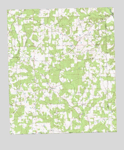
Progress, MS USGS Topographic Map
Click on map above to begin viewing in our Map Viewer.

This topographic map contains these locations and features:
Feature Name Type Latitude Longitude GNIS ID View Map
Alford CemeteryCemeteryN31.0118°W90.3187°709901View Map
Allen CemeteryCemeteryN31.1193°W90.3693°709920View Map
Allen CemeteryCemeteryN31.0852°W90.3665°666202View Map
Allen CemeteryCemeteryN31.0999°W90.3540°666203View Map
Allen CemeteryCemeteryN31.1099°W90.3626°666204View Map
Bala Chitto CemeteryCemeteryN31.1043°W90.3701°709874View Map
Bala Chitto ChurchChurchN31.1035°W90.3704°666478View Map
Bluff Springs ChurchChurchN31.0793°W90.3623°687615View Map
Brewer-Webb CemeteryCemeteryN31.0693°W90.3468°709882View Map
Brumfield CemeteryCemeteryN31.1127°W90.2634°667657View Map
Brumfield CemeteryCemeteryN31.0302°W90.2723°709980View Map
Burch CemeteryCemeteryN31.0143°W90.2693°709883View Map
Burch CemeteryCemeteryN31.0124°W90.2523°667794View Map
Burkhalter CemeteryCemeteryN31.1091°W90.2751°667811View Map
Dykes CrossingPopulated PlaceN31.0980°W90.2854°691830View Map
EmeraldPopulated PlaceN31.0771°W90.3637°691841View Map
Emerald School (historical)SchoolN31.0785°W90.3629°687628View Map
Fortenberry CemeteryCemeteryN31.0024°W90.2798°709906View Map
Fortenberry CemeteryCemeteryN31.0388°W90.2968°709963View Map
GladhurstPopulated PlaceN31.0296°W90.3743°691888View Map
Good Hope School (historical)SchoolN31.0435°W90.3243°687638View Map
Hall CemeteryCemeteryN31.0996°W90.2806°710015View Map
Hall Lake DamDamN31.0868°W90.2984°680566View Map
Hinson CemeteryCemeteryN31.0735°W90.3451°671238View Map
Hucabee CemeteryCemeteryN31.1074°W90.3515°709942View Map
Kendrick-Pounds CemeteryCemeteryN31.0868°W90.3468°709950View Map
Love CreekStreamN31.1185°W90.2526°672899View Map
Magee CemeteryCemeteryN31.0296°W90.3451°673056View Map
Magee CemeteryCemeteryN31.1154°W90.3481°709999View Map
McDaniel CemeteryCemeteryN31.0346°W90.3418°709965View Map
Mogul School (historical)SchoolN31.0313°W90.3265°687659View Map
Mullens CemeteryCemeteryN31.0735°W90.3526°709968View Map
Pleasant Valley ChurchChurchN31.0741°W90.2759°676131View Map
Pound CemeteryCemeteryN31.0885°W90.3451°676282View Map
ProgressPopulated PlaceN31.0463°W90.3268°676344View Map
Progress Baptist ChurchChurchN31.0457°W90.3265°709982View Map
Progress CemeteryCemeteryN31.0449°W90.3279°709983View Map
Progress School (historical)SchoolN31.0446°W90.3259°709984View Map
Progress Volunteer Fire Department Station 1BuildingN31.0468°W90.3268°2332869View Map
Progress Volunteer Fire Department Station 2BuildingN31.1085°W90.2899°2667935View Map
Rimes CemeteryCemeteryN31.0680°W90.3337°676668View Map
Roberts CemeteryCemeteryN31.0291°W90.3245°709907View Map
Rose Hill ChurchChurchN31.1152°W90.3484°676851View Map
Saint Chapel Baptist ChurchChurchN31.0814°W90.2563°2596580View Map
Saint Joseph ChurchChurchN31.0555°W90.3318°677097View Map
Sandifer CemeteryCemeteryN31.0805°W90.3748°677368View Map
Sandifer CemeteryCemeteryN31.0738°W90.3654°710018View Map
Shady Grove ChurchChurchN31.0202°W90.3195°677553View Map
Silver Creek CemeteryCemeteryN31.0863°W90.2695°709995View Map
Silver Creek ChurchChurchN31.0866°W90.2712°677798View Map
Silver Springs CemeteryCemeteryN31.0191°W90.2915°709996View Map
Silver Springs ChurchChurchN31.0191°W90.2906°677806View Map
Simmons CemeteryCemeteryN31.0449°W90.3629°677816View Map
Simmons CemeteryCemeteryN31.0635°W90.3162°677817View Map
Simmons CemeteryCemeteryN31.0821°W90.2834°677818View Map
Simmons CemeteryCemeteryN31.0593°W90.3056°710025View Map
SimmonsvillePopulated PlaceN31.0632°W90.3145°711164View Map
Smith CemeteryCemeteryN31.0188°W90.2795°710030View Map
SmithburgPopulated PlaceN31.0285°W90.2904°692236View Map
State Line ChurchChurchN31.0032°W90.3270°678232View Map
Sweetwater CreekStreamN31.1182°W90.2518°678499View Map
Tangipahoa ChurchChurchN31.0007°W90.3743°678554View Map
Tate CemeteryCemeteryN31.0432°W90.2890°709938View Map
Thomas Grove ChurchChurchN31.0657°W90.2604°678681View Map
Thornhill CemeteryCemeteryN31.1132°W90.2906°678723View Map
Walker BridgeBridgeN31.1171°W90.2515°679260View Map
Walker CemeteryCemeteryN31.1018°W90.2509°679261View Map
Yale College (historical)SchoolN31.1030°W90.3176°687695View Map
Yale Community CenterLocaleN31.1096°W90.3179°679909View Map

Note: Coordinates in the location and feature list above are referenced to NAD83 datum.


Copyright (C) 2008-2024 Ryan Niemi / Sunset Dynamics ... All Rights Reserved