TopoQuest Logo
Do you find TopoQuest useful?
Help keep TopoQuest running and adding new maps/features by donating!
Bitcoin:  19c7KJd3qBynnjoSw5npx9KScwjBe4ifkT
Litecoin:  LXs6TkuXGGXo1vDsWCkWVdjQX94eUKd6ui
Home View Maps Find Maps Find Places Resources & Links


Romney, West Virginia Topographic Map

USGS Map Title: Romney, WV
USGS Map MRC: 39078C7
DRG (GeoTIFF) Download: o39078c7.tif


Neighboring USGS Topographic Map Quads:


  Keyser, WV  
39078D8
 

  Headsville, WV  
39078D7
 

  Springfield, WV  
39078D6
 

  Burlington, WV  
39078C8
 

  Romney, WV  
39078C7
 

  Augusta, WV  
39078C6
 

  Old Fields, WV  
39078B8
 

  Sector, WV  
39078B7
 

  Rio, WV  
39078B6


Map MRC Location:

N40°
W79°
N40°
W78°
H8 H7 H6 H5 H4 H3 H2 H1
G8 G7 G6 G5 G4 G3 G2 G1
F8 F7 F6 F5 F4 F3 F2 F1
E8 E7 E6 E5 E4 E3 E2 E1
D8 D7 D6 D5 D4 D3 D2 D1
C8 C7 C6 C5 C4 C3 C2 C1
B8 B7 B6 B5 B4 B3 B2 B1
A8 A7 A6 A5 A4 A3 A2 A1
N39°
W79°
N39°
W78°

Romney, WV USGS 1:24K Topographic Map Preview:
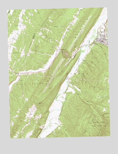
Romney, WV USGS Topographic Map
Click on map above to begin viewing in our Map Viewer.

This topographic map contains these locations and features:
Feature Name Type Latitude Longitude GNIS ID View Map
Beaver Run ChurchChurchN39.3468°W78.8678°1535457View Map
Beaver Run School (historical)SchoolN39.3470°W78.8670°1557038View Map
Bethesda Church (historical)ChurchN39.2626°W78.8134°1556742View Map
Bever Run CemeteryCemeteryN39.3465°W78.8731°1936840View Map
Big RunStreamN39.3640°W78.7559°1535949View Map
Buffalo RunStreamN39.2637°W78.8239°1536654View Map
Church of ChristChurchN39.3448°W78.7553°1718617View Map
City of RomneyCivilN39.3455°W78.7564°2390646View Map
Clifford Parker SpringSpringN39.3170°W78.8247°1677925View Map
Core RunStreamN39.3273°W78.7967°1537685View Map
Dry RunStreamN39.3059°W78.8036°1538377View Map
Dumpling RunStreamN39.3354°W78.8097°1538423View Map
Fairview MountainSummitN39.2837°W78.8384°1557995View Map
Fort Mill Ridge Wildlife Management AreaParkN39.3251°W78.7909°2043523View Map
Fort Pearsall (historical)MilitaryN39.3431°W78.7667°1718638View Map
Hampshire Club (historical)LocaleN39.2876°W78.8111°1556770View Map
Hampshire Convention and Visitors BureauBuildingN39.3388°W78.7516°2727317View Map
Hampshire County CourthouseBuildingN39.3428°W78.7556°1718646View Map
Hampshire County Sheriff's OfficeBuildingN39.3424°W78.7558°2727932View Map
Horselick RunStreamN39.3023°W78.8739°1540501View Map
Indian Mound CemeteryCemeteryN39.3426°W78.7658°1718701View Map
JohnsonPopulated PlaceN39.2757°W78.8256°1554818View Map
JunctionPopulated PlaceN39.3132°W78.8628°1558371View Map
Lamberts Ambulance Service 1BuildingN39.3407°W78.7564°2581038View Map
Literary HallBuildingN39.3423°W78.7567°1718668View Map
Long Meadow RunStreamN39.3412°W78.8095°1542389View Map
Maranatha Christian AcademySchoolN39.3571°W78.7526°2088256View Map
Mayhew RunStreamN39.3545°W78.8006°1542897View Map
McDowell RunStreamN39.3173°W78.7934°1542993View Map
MechanicsburgPopulated PlaceN39.3354°W78.8103°1549817View Map
Mechanicsburg School (historical)SchoolN39.3490°W78.8031°1556782View Map
Mill CreekStreamN39.3357°W78.7845°1543325View Map
Mill Creek MountainRidgeN39.2932°W78.8328°1543330View Map
Mill RunStreamN39.3023°W78.8014°1543353View Map
Mill Run CemeteryCemeteryN39.2945°W78.7913°2726654View Map
Miller McCarty CemeteryCemeteryN39.3726°W78.8745°1937378View Map
Mount Pisgah Benevolence CemeteryCemeteryN39.3420°W78.7672°2726657View Map
PancakePopulated PlaceN39.2582°W78.8339°1555298View Map
Pancake School (historical)SchoolN39.3020°W78.7997°1556787View Map
Patterson Creek Structure 27 DamDamN39.3718°W78.8731°1559098View Map
Paul Williams SpringSpringN39.3376°W78.7895°1677927View Map
Potomac CenterSchoolN39.3524°W78.7572°2631505View Map
RomneyPopulated PlaceN39.3420°W78.7567°1560582View Map
Romney BridgeBridgeN39.3390°W78.7760°2646954View Map
Romney Christian ChurchChurchN39.3443°W78.7595°1718702View Map
Romney Church of the NazareneChurchN39.3468°W78.7586°1718703View Map
Romney Classical Institute (historical)SchoolN39.3393°W78.7506°1718704View Map
Romney DistrictCivilN39.2924°W78.7882°1928347View Map
Romney Elementary SchoolSchoolN39.3434°W78.7646°1718705View Map
Romney Junction (historical)LocaleN39.3570°W78.7584°1718706View Map
Romney Police DepartmentBuildingN39.3399°W78.7527°2727931View Map
Romney Post OfficePost OfficeN39.3430°W78.7576°1718708View Map
Romney SpringSpringN39.3287°W78.8031°1677926View Map
Romney Volunteer Fire DepartmentBuildingN39.3404°W78.7578°2577650View Map
Romney Volunteer Rescue Squad Company 11BuildingN39.3502°W78.7574°2581148View Map
Rosedale School (historical)SchoolN39.2545°W78.8236°1556796View Map
South Branch School (historical)SchoolN39.3259°W78.7972°1556802View Map
Stony RunStreamN39.2520°W78.8386°1547507View Map
Stump RunStreamN39.3268°W78.7864°1547600View Map
Sugar RunStreamN39.3337°W78.8111°1547648View Map
Sulphur Spring RunStreamN39.3473°W78.7634°1547721View Map
Titus RunStreamN39.3273°W78.8189°1548107View Map
Trinity ChurchChurchN39.3062°W78.8597°1548271View Map
Union School (historical)SchoolN39.3154°W78.8686°1718728View Map
Valley (historical)Populated PlaceN39.3550°W78.7652°2747081View Map
Wergman RunStreamN39.3379°W78.7761°1548909View Map
West Romney Station (historical)LocaleN39.3373°W78.7845°1556816View Map
West Virginia Division of Forestry Romney Field OfficeBuildingN39.3486°W78.7550°2577810View Map
West Virginia School for the BlindSchoolN39.3415°W78.7512°1718732View Map
West Virginia State Police Troop 2 - Romney DetachmentBuildingN39.3497°W78.7587°2727933View Map
Whip CemeteryCemeteryN39.3537°W78.8684°1937414View Map
WJGF-FM (Romney)TowerN39.3404°W78.7509°1559836View Map

Note: Coordinates in the location and feature list above are referenced to NAD83 datum.


Copyright (C) 2008-2025 Ryan Niemi / Sunset Dynamics ... All Rights Reserved