TopoQuest Logo
Do you find TopoQuest useful?
Help keep TopoQuest running and adding new maps/features by donating!
Bitcoin:  19c7KJd3qBynnjoSw5npx9KScwjBe4ifkT
Litecoin:  LXs6TkuXGGXo1vDsWCkWVdjQX94eUKd6ui
Home View Maps Find Maps Find Places Resources & Links


Sultan, Washington Topographic Map

USGS Map Title: Sultan, WA
USGS Map MRC: 47121G7
DRG (GeoTIFF) Download: o47121g7.tif


Neighboring USGS Topographic Map Quads:


  Lake Roesiger, WA  
47121H8
 

  Lake Chaplain, WA  
47121H7
 

  Wallace Lake, WA  
47121H6
 

  Monroe, WA  
47121G8
 

  Sultan, WA  
47121G7
 

  Gold Bar, WA  
47121G6
 

  Carnation, WA  
47121F8
 

  Lake Joy, WA  
47121F7
 

  Devils Slide, WA  
47121F6


Map MRC Location:

N48°
W122°
N48°
W121°
H8 H7 H6 H5 H4 H3 H2 H1
G8 G7 G6 G5 G4 G3 G2 G1
F8 F7 F6 F5 F4 F3 F2 F1
E8 E7 E6 E5 E4 E3 E2 E1
D8 D7 D6 D5 D4 D3 D2 D1
C8 C7 C6 C5 C4 C3 C2 C1
B8 B7 B6 B5 B4 B3 B2 B1
A8 A7 A6 A5 A4 A3 A2 A1
N47°
W122°
N47°
W121°

Sultan, WA USGS 1:24K Topographic Map Preview:
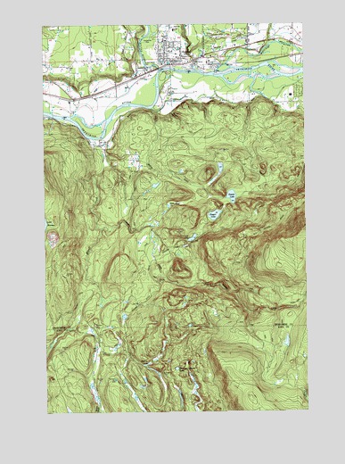
Sultan, WA USGS Topographic Map
Click on map above to begin viewing in our Map Viewer.

This topographic map contains these locations and features:
Feature Name Type Latitude Longitude GNIS ID View Map
Cedar Ponds LakeLakeN47.8059°W121.8054°1517575View Map
Centennial ParkParkN47.8698°W121.8254°1533356View Map
Cherry Hill Estates Mobile Home ParkPopulated PlaceN47.8604°W121.8290°2607547View Map
Cherry LakeLakeN47.7654°W121.8275°1517662View Map
City of SultanCivilN47.8704°W121.8035°2411999View Map
Crandall CreekStreamN47.8068°W121.8243°1518276View Map
Dagger LakeReservoirN47.8133°W121.7949°1518448View Map
Dagger Lake DamDamN47.8148°W121.7912°1532184View Map
Double M RanchLocaleN47.8431°W121.8408°2706257View Map
Drunken Charlie LakeLakeN47.7639°W121.8137°1518931View Map
Elwell CreekStreamN47.8379°W121.8529°1519319View Map
Groeneveld FarmsLocaleN47.8542°W121.8361°2706083View Map
Haystack LookoutLocaleN47.8090°W121.7507°1520630View Map
Hofstra DairyLocaleN47.8506°W121.8508°2705924View Map
Lake DorothySwampN47.7858°W121.8481°1530298View Map
Lake ElsieLakeN47.8163°W121.8168°1519317View Map
McCoy CreekStreamN47.8476°W121.8243°1522874View Map
McCoy Creek DamDamN47.8432°W121.8229°1532678View Map
Roesler Timber Company HeliportAirportN47.8682°W121.7529°1533986View Map
Rudolf Reese ParkParkN47.8629°W121.8293°1533355View Map
Sky Harbor AirportAirportN47.8707°W121.7923°1533988View Map
Sky Valley Options High SchoolSchoolN47.8663°W121.8157°2518495View Map
Snohomish County Fire District 5 Station 51BuildingN47.8628°W121.8176°2619379View Map
SultanPopulated PlaceN47.8626°W121.8165°1526700View Map
Sultan Elementary SchoolSchoolN47.8663°W121.8151°1530692View Map
Sultan Elementary SchoolSchoolN47.8659°W121.8146°1533401View Map
Sultan Fire DepartmentBuildingN47.8657°W121.7893°2767950View Map
Sultan High SchoolSchoolN47.8734°W121.8140°1533400View Map
Sultan High SchoolSchoolN47.8731°W121.8133°2518475View Map
Sultan Middle SchoolSchoolN47.8694°W121.8175°1530691View Map
Sultan Middle SchoolSchoolN47.8698°W121.8168°1533399View Map
Sultan Mill PondReservoirN47.8649°W121.8001°1532819View Map
Sultan Mill Pond DamDamN47.8632°W121.7996°1532818View Map
Sultan Police DepartmentBuildingN47.8626°W121.8138°2722089View Map
Sultan Post OfficePost OfficeN47.8621°W121.8162°2781624View Map
Sultan RiverStreamN47.8607°W121.8204°1526702View Map
Sultan River BridgeBridgeN47.8607°W121.8206°2608033View Map
Sultan Wastewater Treatment Plant and Sewage Treatment PlantLocaleN47.8608°W121.8235°2610729View Map
Timberline Mobile Home VillagePopulated PlaceN47.8641°W121.8104°2607548View Map
Tomtit LakeLakeN47.8193°W121.7864°1527297View Map
Wagleys CreekStreamN47.8598°W121.8032°1527744View Map
Wallace RiverStreamN47.8593°W121.7976°1527776View Map
West Mobile ParkPopulated PlaceN47.8607°W121.8248°2607550View Map
Youngs CreekStreamN47.8093°W121.8487°1528370View Map

Note: Coordinates in the location and feature list above are referenced to NAD83 datum.


Copyright (C) 2008-2025 Ryan Niemi / Sunset Dynamics ... All Rights Reserved